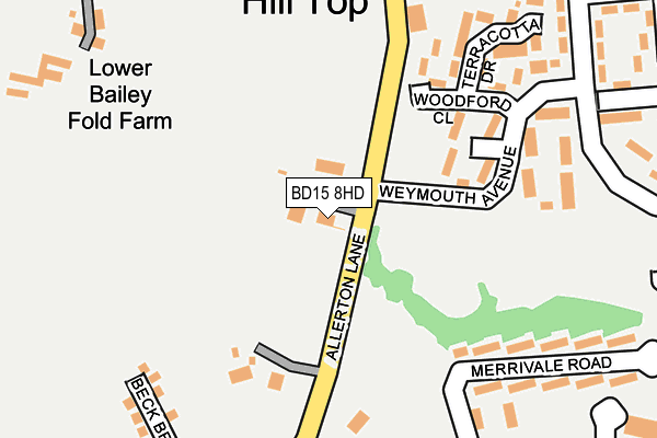
BD15 8HD is located in the Thornton and Allerton electoral ward, within the metropolitan district of Bradford and the English Parliamentary constituency of Bradford West. The Sub Integrated Care Board (ICB) Location is NHS West Yorkshire ICB - 36J and the police force is West Yorkshire. This postcode has been in use since July 2017.


GetTheData
Source: OS OpenMap – Local (Ordnance Survey)
Source: OS VectorMap District (Ordnance Survey)
Licence: Open Government Licence (requires attribution)
| Easting | 411149 |
| Northing | 433746 |
| Latitude | 53.799914 |
| Longitude | -1.832215 |
GetTheData
Source: Open Postcode Geo
Licence: Open Government Licence
| Country | England |
| Postcode District | BD15 |
➜ See where BD15 is on a map ➜ Where is Bradford? | |
GetTheData
Source: Land Registry Price Paid Data
Licence: Open Government Licence
| Ward | Thornton And Allerton |
| Constituency | Bradford West |
GetTheData
Source: ONS Postcode Database
Licence: Open Government Licence
35, BECK BRIDGE LANE, ALLERTON, BRADFORD, BD15 8HD 2019 23 SEP £187,995 |
29, BECK BRIDGE LANE, ALLERTON, BRADFORD, BD15 8HD 2019 6 SEP £192,995 |
1, BECK BRIDGE LANE, ALLERTON, BRADFORD, BD15 8HD 2018 22 OCT £184,950 |
21, BECK BRIDGE LANE, ALLERTON, BRADFORD, BD15 8HD 2018 3 OCT £214,995 |
27, BECK BRIDGE LANE, ALLERTON, BRADFORD, BD15 8HD 2018 31 AUG £179,995 |
53, BECK BRIDGE LANE, ALLERTON, BRADFORD, BD15 8HD 2017 28 DEC £205,000 |
GetTheData
Source: HM Land Registry Price Paid Data
Licence: Contains HM Land Registry data © Crown copyright and database right 2025. This data is licensed under the Open Government Licence v3.0.
| Bracewell Ave Merrivale Rd (Bracewell Avenue) | Allerton | 296m |
| Bracewell Ave Merrivale Rd (Bracewell Avenue) | Allerton | 335m |
| Ayresome Oval Bracewell Ave (Ayresome Oval) | Allerton | 383m |
| Saffron Drive Weymouth Ave (Saffron Drive) | Allerton | 389m |
| Saffron Drive Weymouth Ave (Saffron Drive) | Allerton | 401m |
| Frizinghall Station | 4.7km |
| Saltaire Station | 5.1km |
| Shipley Station | 5.3km |
GetTheData
Source: NaPTAN
Licence: Open Government Licence
| Percentage of properties with Next Generation Access | 100.0% |
| Percentage of properties with Superfast Broadband | 100.0% |
| Percentage of properties with Ultrafast Broadband | 96.4% |
| Percentage of properties with Full Fibre Broadband | 96.4% |
Superfast Broadband is between 30Mbps and 300Mbps
Ultrafast Broadband is > 300Mbps
| Percentage of properties unable to receive 2Mbps | 0.0% |
| Percentage of properties unable to receive 5Mbps | 0.0% |
| Percentage of properties unable to receive 10Mbps | 0.0% |
| Percentage of properties unable to receive 30Mbps | 0.0% |
GetTheData
Source: Ofcom
Licence: Ofcom Terms of Use (requires attribution)
GetTheData
Source: ONS Postcode Database
Licence: Open Government Licence


➜ Get more ratings from the Food Standards Agency
GetTheData
Source: Food Standards Agency
Licence: FSA terms & conditions
| Last Collection | |||
|---|---|---|---|
| Location | Mon-Fri | Sat | Distance |
| Allerton Franchise P.o. Box | 17:15 | 12:15 | 929m |
| Town End Road Clayton | 17:15 | 12:00 | 1,856m |
| 61 The Avenue Clayton | 17:45 | 12:00 | 1,878m |
GetTheData
Source: Dracos
Licence: Creative Commons Attribution-ShareAlike
The below table lists the International Territorial Level (ITL) codes (formerly Nomenclature of Territorial Units for Statistics (NUTS) codes) and Local Administrative Units (LAU) codes for BD15 8HD:
| ITL 1 Code | Name |
|---|---|
| TLE | Yorkshire and The Humber |
| ITL 2 Code | Name |
| TLE4 | West Yorkshire |
| ITL 3 Code | Name |
| TLE41 | Bradford |
| LAU 1 Code | Name |
| E08000032 | Bradford |
GetTheData
Source: ONS Postcode Directory
Licence: Open Government Licence
The below table lists the Census Output Area (OA), Lower Layer Super Output Area (LSOA), and Middle Layer Super Output Area (MSOA) for BD15 8HD:
| Code | Name | |
|---|---|---|
| OA | E00054455 | |
| LSOA | E01010802 | Bradford 036F |
| MSOA | E02002218 | Bradford 036 |
GetTheData
Source: ONS Postcode Directory
Licence: Open Government Licence
| BD15 8HB | Allerton Lane | 114m |
| BD15 7TB | Bracewell Avenue | 172m |
| BD15 7UL | Chevet Mount | 276m |
| BD15 7JL | Woodford Close | 285m |
| BD15 8AA | Bailey Fold | 297m |
| BD15 7TA | Merrivale Road | 301m |
| BD15 7SL | Merrivale Road | 305m |
| BD15 7SZ | Ormonde Drive | 313m |
| BD15 7UP | Ayresome Oval | 317m |
| BD15 7JJ | Weymouth Avenue | 321m |
GetTheData
Source: Open Postcode Geo; Land Registry Price Paid Data
Licence: Open Government Licence