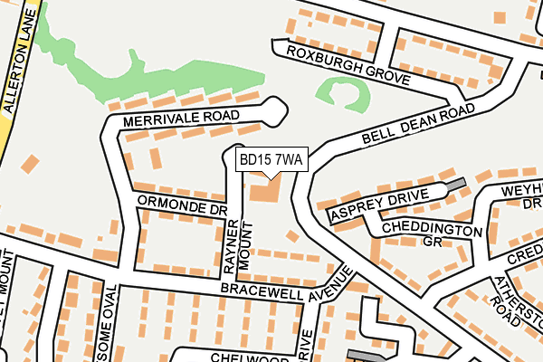
BD15 7WA is located in the Thornton and Allerton electoral ward, within the metropolitan district of Bradford and the English Parliamentary constituency of Bradford West. The Sub Integrated Care Board (ICB) Location is NHS West Yorkshire ICB - 36J and the police force is West Yorkshire. This postcode has been in use since September 2002.


GetTheData
Source: OS OpenMap – Local (Ordnance Survey)
Source: OS VectorMap District (Ordnance Survey)
Licence: Open Government Licence (requires attribution)
| Easting | 411562 |
| Northing | 433572 |
| Latitude | 53.798341 |
| Longitude | -1.825951 |
GetTheData
Source: Open Postcode Geo
Licence: Open Government Licence
| Country | England |
| Postcode District | BD15 |
➜ See where BD15 is on a map ➜ Where is Bradford? | |
GetTheData
Source: Land Registry Price Paid Data
Licence: Open Government Licence
Elevation or altitude of BD15 7WA as distance above sea level:
| Metres | Feet | |
|---|---|---|
| Elevation | 190m | 623ft |
Elevation is measured from the approximate centre of the postcode, to the nearest point on an OS contour line from OS Terrain 50, which has contour spacing of ten vertical metres.
➜ How high above sea level am I? Find the elevation of your current position using your device's GPS.
GetTheData
Source: Open Postcode Elevation
Licence: Open Government Licence
| Ward | Thornton And Allerton |
| Constituency | Bradford West |
GetTheData
Source: ONS Postcode Database
Licence: Open Government Licence
| Bell Dean Road Bracewell Ave (Bell Dean Road) | Allerton | 47m |
| Bracewell Avenue Rayner Mount (Bracewell Avenue) | Allerton | 69m |
| Bracewell Avenue Rayner Mount (Bracewell Avenue) | Allerton | 76m |
| Bracewell Avenue Bell Dean Rd (Bracewell Avenue) | Allerton | 79m |
| Bell Dean Road Bracewell Ave (Bell Dean Road) | Allerton | 110m |
| Frizinghall Station | 4.5km |
| Bradford Forster Square Station | 4.8km |
| Saltaire Station | 5km |
GetTheData
Source: NaPTAN
Licence: Open Government Licence
GetTheData
Source: ONS Postcode Database
Licence: Open Government Licence


➜ Get more ratings from the Food Standards Agency
GetTheData
Source: Food Standards Agency
Licence: FSA terms & conditions
| Last Collection | |||
|---|---|---|---|
| Location | Mon-Fri | Sat | Distance |
| Allerton Franchise P.o. Box | 17:15 | 12:15 | 849m |
| Town End Road Clayton | 17:15 | 12:00 | 1,535m |
| 61 The Avenue Clayton | 17:45 | 12:00 | 1,622m |
GetTheData
Source: Dracos
Licence: Creative Commons Attribution-ShareAlike
The below table lists the International Territorial Level (ITL) codes (formerly Nomenclature of Territorial Units for Statistics (NUTS) codes) and Local Administrative Units (LAU) codes for BD15 7WA:
| ITL 1 Code | Name |
|---|---|
| TLE | Yorkshire and The Humber |
| ITL 2 Code | Name |
| TLE4 | West Yorkshire |
| ITL 3 Code | Name |
| TLE41 | Bradford |
| LAU 1 Code | Name |
| E08000032 | Bradford |
GetTheData
Source: ONS Postcode Directory
Licence: Open Government Licence
The below table lists the Census Output Area (OA), Lower Layer Super Output Area (LSOA), and Middle Layer Super Output Area (MSOA) for BD15 7WA:
| Code | Name | |
|---|---|---|
| OA | E00054443 | |
| LSOA | E01010802 | Bradford 036F |
| MSOA | E02002218 | Bradford 036 |
GetTheData
Source: ONS Postcode Directory
Licence: Open Government Licence
| BD15 7SU | Rayner Mount | 80m |
| BD15 7TS | Cheddington Grove | 114m |
| BD15 7YA | Coxwold Walk | 125m |
| BD15 7TF | Bell Dean Road | 129m |
| BD15 7WJ | Woodpecker Close | 132m |
| BD15 7SZ | Ormonde Drive | 135m |
| BD15 7TD | Bracewell Avenue | 147m |
| BD15 7YD | Chelwood Drive | 157m |
| BD15 7SL | Merrivale Road | 161m |
| BD15 7YR | Greenway Drive | 161m |
GetTheData
Source: Open Postcode Geo; Land Registry Price Paid Data
Licence: Open Government Licence