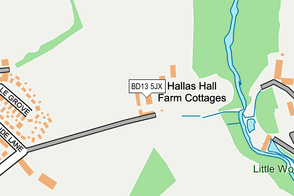
BD13 5JX lies on Hallas Lane in Cullingworth, Bradford. BD13 5JX is located in the Bingley Rural electoral ward, within the metropolitan district of Bradford and the English Parliamentary constituency of Shipley. The Sub Integrated Care Board (ICB) Location is NHS West Yorkshire ICB - 36J and the police force is West Yorkshire. This postcode has been in use since June 2000.


GetTheData
Source: OS OpenMap – Local (Ordnance Survey)
Source: OS VectorMap District (Ordnance Survey)
Licence: Open Government Licence (requires attribution)
| Easting | 407518 |
| Northing | 436533 |
| Latitude | 53.825014 |
| Longitude | -1.887272 |
GetTheData
Source: Open Postcode Geo
Licence: Open Government Licence
| Street | Hallas Lane |
| Locality | Cullingworth |
| Town/City | Bradford |
| Country | England |
| Postcode District | BD13 |
➜ See where BD13 is on a map | |
GetTheData
Source: Land Registry Price Paid Data
Licence: Open Government Licence
Elevation or altitude of BD13 5JX as distance above sea level:
| Metres | Feet | |
|---|---|---|
| Elevation | 200m | 656ft |
Elevation is measured from the approximate centre of the postcode, to the nearest point on an OS contour line from OS Terrain 50, which has contour spacing of ten vertical metres.
➜ How high above sea level am I? Find the elevation of your current position using your device's GPS.
GetTheData
Source: Open Postcode Elevation
Licence: Open Government Licence
| Ward | Bingley Rural |
| Constituency | Shipley |
GetTheData
Source: ONS Postcode Database
Licence: Open Government Licence
| Westhill Ave Greenside Lane (Westhill Avenue) | Cullingworth | 349m |
| Westhill Ave Greenside Lane (Westhill Avenue) | Cullingworth | 354m |
| Greenside Lane Birkdale Close (Greenside Lane) | Cullingworth | 468m |
| Parkside School (Parkside Terrace) | Cullingworth | 470m |
| Parkside School (Parkside Terrace) | Cullingworth | 472m |
| Bingley Station | 4.2km |
| Crossflatts Station | 4.7km |
| Keighley Station | 4.9km |
GetTheData
Source: NaPTAN
Licence: Open Government Licence
| Percentage of properties with Next Generation Access | 100.0% |
| Percentage of properties with Superfast Broadband | 100.0% |
| Percentage of properties with Ultrafast Broadband | 0.0% |
| Percentage of properties with Full Fibre Broadband | 0.0% |
Superfast Broadband is between 30Mbps and 300Mbps
Ultrafast Broadband is > 300Mbps
| Percentage of properties unable to receive 2Mbps | 0.0% |
| Percentage of properties unable to receive 5Mbps | 0.0% |
| Percentage of properties unable to receive 10Mbps | 0.0% |
| Percentage of properties unable to receive 30Mbps | 0.0% |
GetTheData
Source: Ofcom
Licence: Ofcom Terms of Use (requires attribution)
GetTheData
Source: ONS Postcode Database
Licence: Open Government Licence


➜ Get more ratings from the Food Standards Agency
GetTheData
Source: Food Standards Agency
Licence: FSA terms & conditions
| Last Collection | |||
|---|---|---|---|
| Location | Mon-Fri | Sat | Distance |
| Fieldhead Estate | 17:00 | 12:00 | 2,093m |
| Harden P.o. Box | 17:15 | 11:45 | 2,115m |
| Hainworth Village | 17:15 | 12:00 | 2,973m |
GetTheData
Source: Dracos
Licence: Creative Commons Attribution-ShareAlike
The below table lists the International Territorial Level (ITL) codes (formerly Nomenclature of Territorial Units for Statistics (NUTS) codes) and Local Administrative Units (LAU) codes for BD13 5JX:
| ITL 1 Code | Name |
|---|---|
| TLE | Yorkshire and The Humber |
| ITL 2 Code | Name |
| TLE4 | West Yorkshire |
| ITL 3 Code | Name |
| TLE41 | Bradford |
| LAU 1 Code | Name |
| E08000032 | Bradford |
GetTheData
Source: ONS Postcode Directory
Licence: Open Government Licence
The below table lists the Census Output Area (OA), Lower Layer Super Output Area (LSOA), and Middle Layer Super Output Area (MSOA) for BD13 5JX:
| Code | Name | |
|---|---|---|
| OA | E00053491 | |
| LSOA | E01010592 | Bradford 031B |
| MSOA | E02002213 | Bradford 031 |
GetTheData
Source: ONS Postcode Directory
Licence: Open Government Licence
| BD13 5BU | Hallas Lane | 19m |
| BD13 5BT | Hallas Bridge | 280m |
| BD13 5AU | Ainsdale Grove | 289m |
| BD13 5AP | Greenside Lane | 322m |
| BD13 5BX | Hallas Lane | 388m |
| BD13 5BB | Westhill Avenue | 407m |
| BD13 5BA | Sunningdale Crescent | 457m |
| BD13 5AW | Greenfield Crescent | 460m |
| BD13 5AX | Barclay Close | 484m |
| BD13 5BJ | Springfield Terrace | 512m |
GetTheData
Source: Open Postcode Geo; Land Registry Price Paid Data
Licence: Open Government Licence