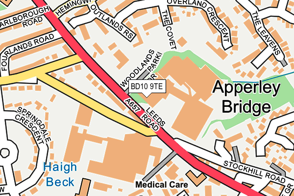
BD10 9TE is located in the Idle and Thackley electoral ward, within the metropolitan district of Bradford and the English Parliamentary constituency of Bradford East. The Sub Integrated Care Board (ICB) Location is NHS West Yorkshire ICB - 36J and the police force is West Yorkshire. This postcode has been in use since January 1980.


GetTheData
Source: OS OpenMap – Local (Ordnance Survey)
Source: OS VectorMap District (Ordnance Survey)
Licence: Open Government Licence (requires attribution)
| Easting | 418697 |
| Northing | 437543 |
| Latitude | 53.833827 |
| Longitude | -1.717391 |
GetTheData
Source: Open Postcode Geo
Licence: Open Government Licence
| Country | England |
| Postcode District | BD10 |
➜ See where BD10 is on a map ➜ Where is Bradford? | |
GetTheData
Source: Land Registry Price Paid Data
Licence: Open Government Licence
Elevation or altitude of BD10 9TE as distance above sea level:
| Metres | Feet | |
|---|---|---|
| Elevation | 80m | 262ft |
Elevation is measured from the approximate centre of the postcode, to the nearest point on an OS contour line from OS Terrain 50, which has contour spacing of ten vertical metres.
➜ How high above sea level am I? Find the elevation of your current position using your device's GPS.
GetTheData
Source: Open Postcode Elevation
Licence: Open Government Licence
| Ward | Idle And Thackley |
| Constituency | Bradford East |
GetTheData
Source: ONS Postcode Database
Licence: Open Government Licence
| Leeds Road Albion Rd (Leeds Road) | Greengates | 50m |
| Leeds Road Albion Rd (Leeds Road) | Greengates | 70m |
| Leeds Road Albion Rd (New Line) | Greengates | 108m |
| Leeds Rd Marlborough Road (Leeds Road) | Idle | 300m |
| Old Park Rd Springdale Crescent (Old Park Road) | Thorpe Edge | 301m |
| Apperley Bridge Station | 1.2km |
| Baildon Station | 3km |
| Shipley Station | 3.7km |
GetTheData
Source: NaPTAN
Licence: Open Government Licence
GetTheData
Source: ONS Postcode Database
Licence: Open Government Licence


➜ Get more ratings from the Food Standards Agency
GetTheData
Source: Food Standards Agency
Licence: FSA terms & conditions
| Last Collection | |||
|---|---|---|---|
| Location | Mon-Fri | Sat | Distance |
| Albion Road | 18:00 | 12:30 | 77m |
| 11 Parkland Drive | 18:00 | 12:00 | 462m |
| Greengates P.o. Box | 17:15 | 12:15 | 476m |
GetTheData
Source: Dracos
Licence: Creative Commons Attribution-ShareAlike
The below table lists the International Territorial Level (ITL) codes (formerly Nomenclature of Territorial Units for Statistics (NUTS) codes) and Local Administrative Units (LAU) codes for BD10 9TE:
| ITL 1 Code | Name |
|---|---|
| TLE | Yorkshire and The Humber |
| ITL 2 Code | Name |
| TLE4 | West Yorkshire |
| ITL 3 Code | Name |
| TLE41 | Bradford |
| LAU 1 Code | Name |
| E08000032 | Bradford |
GetTheData
Source: ONS Postcode Directory
Licence: Open Government Licence
The below table lists the Census Output Area (OA), Lower Layer Super Output Area (LSOA), and Middle Layer Super Output Area (MSOA) for BD10 9TE:
| Code | Name | |
|---|---|---|
| OA | E00053885 | |
| LSOA | E01010689 | Bradford 019F |
| MSOA | E02002201 | Bradford 019 |
GetTheData
Source: ONS Postcode Directory
Licence: Open Government Licence
| BD10 9TD | Leeds Road | 45m |
| BD10 9NT | Three Nooked Mews | 57m |
| BD10 9SX | Leeds Road | 146m |
| BD10 9TH | The Covet | 161m |
| BD10 9TR | Outlands Rise | 164m |
| BD10 9AY | Stockhill Fold | 189m |
| BD10 9TG | Overland Crescent | 191m |
| BD10 9TJ | Strangford Court | 198m |
| BD10 9SS | Leeds Road | 199m |
| BD10 9AS | New Line | 207m |
GetTheData
Source: Open Postcode Geo; Land Registry Price Paid Data
Licence: Open Government Licence