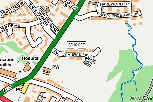
BD10 0FF is located in the Idle and Thackley electoral ward, within the metropolitan district of Bradford and the English Parliamentary constituency of Bradford East. The Sub Integrated Care Board (ICB) Location is NHS West Yorkshire ICB - 36J and the police force is West Yorkshire. This postcode has been in use since March 2017.


GetTheData
Source: OS OpenMap – Local (Ordnance Survey)
Source: OS VectorMap District (Ordnance Survey)
Licence: Open Government Licence (requires attribution)
| Easting | 419346 |
| Northing | 437455 |
| Latitude | 53.833012 |
| Longitude | -1.707535 |
GetTheData
Source: Open Postcode Geo
Licence: Open Government Licence
| Country | England |
| Postcode District | BD10 |
➜ See where BD10 is on a map ➜ Where is Bradford? | |
GetTheData
Source: Land Registry Price Paid Data
Licence: Open Government Licence
| Ward | Idle And Thackley |
| Constituency | Bradford East |
GetTheData
Source: ONS Postcode Database
Licence: Open Government Licence
4, VALLEY VIEW DRIVE, APPERLEY BRIDGE, BRADFORD, BD10 0FF 2020 5 MAR £410,000 |
2, VALLEY VIEW DRIVE, APPERLEY BRIDGE, BRADFORD, BD10 0FF 2020 31 JAN £484,950 |
6, VALLEY VIEW DRIVE, APPERLEY BRIDGE, BRADFORD, BD10 0FF 2019 25 OCT £285,950 |
26, VALLEY VIEW DRIVE, GREENGATES, BRADFORD, BD10 0FF 2018 26 JAN £364,950 |
7, VALLEY VIEW DRIVE, GREENGATES, BRADFORD, BD10 0FF 2017 28 APR £391,950 |
16, VALLEY VIEW DRIVE, GREENGATES, BRADFORD, BD10 0FF 2017 28 APR £394,950 |
5, VALLEY VIEW DRIVE, GREENGATES, BRADFORD, BD10 0FF 2017 27 APR £391,950 |
GetTheData
Source: HM Land Registry Price Paid Data
Licence: Contains HM Land Registry data © Crown copyright and database right 2025. This data is licensed under the Open Government Licence v3.0.
| Harrogate Road Tenterfields (Harrogate Road) | Apperley Bridge | 109m |
| Harrogate Road Tenterfields (Harrogate Road) | Apperley Bridge | 112m |
| Harrogate Road Carr Bottom Rd (Harrogate Road) | Greengates | 184m |
| Harrogate Rd Stockhill Road (Harrogate Road) | Greengates | 256m |
| Harrogate Road Laburnum Place (Harrogate Road) | Apperley Bridge | 270m |
| Apperley Bridge Station | 1km |
| Baildon Station | 3.6km |
| New Pudsey Station | 3.6km |
GetTheData
Source: NaPTAN
Licence: Open Government Licence
| Percentage of properties with Next Generation Access | 100.0% |
| Percentage of properties with Superfast Broadband | 100.0% |
| Percentage of properties with Ultrafast Broadband | 100.0% |
| Percentage of properties with Full Fibre Broadband | 100.0% |
Superfast Broadband is between 30Mbps and 300Mbps
Ultrafast Broadband is > 300Mbps
| Percentage of properties unable to receive 2Mbps | 0.0% |
| Percentage of properties unable to receive 5Mbps | 0.0% |
| Percentage of properties unable to receive 10Mbps | 0.0% |
| Percentage of properties unable to receive 30Mbps | 0.0% |
GetTheData
Source: Ofcom
Licence: Ofcom Terms of Use (requires attribution)
GetTheData
Source: ONS Postcode Database
Licence: Open Government Licence


➜ Get more ratings from the Food Standards Agency
GetTheData
Source: Food Standards Agency
Licence: FSA terms & conditions
| Last Collection | |||
|---|---|---|---|
| Location | Mon-Fri | Sat | Distance |
| Tenterfields | 17:15 | 12:00 | 180m |
| Apperley Bridge | 17:15 | 12:00 | 235m |
| Greengates P.o. Box | 17:15 | 12:15 | 266m |
GetTheData
Source: Dracos
Licence: Creative Commons Attribution-ShareAlike
The below table lists the International Territorial Level (ITL) codes (formerly Nomenclature of Territorial Units for Statistics (NUTS) codes) and Local Administrative Units (LAU) codes for BD10 0FF:
| ITL 1 Code | Name |
|---|---|
| TLE | Yorkshire and The Humber |
| ITL 2 Code | Name |
| TLE4 | West Yorkshire |
| ITL 3 Code | Name |
| TLE41 | Bradford |
| LAU 1 Code | Name |
| E08000032 | Bradford |
GetTheData
Source: ONS Postcode Directory
Licence: Open Government Licence
The below table lists the Census Output Area (OA), Lower Layer Super Output Area (LSOA), and Middle Layer Super Output Area (MSOA) for BD10 0FF:
| Code | Name | |
|---|---|---|
| OA | E00053906 | |
| LSOA | E01010683 | Bradford 017A |
| MSOA | E02002199 | Bradford 017 |
GetTheData
Source: ONS Postcode Directory
Licence: Open Government Licence
| BD10 0LU | Derby Terrace | 150m |
| BD10 0UG | Roundhead Fold | 162m |
| BD10 0TY | Dyehouse Court | 169m |
| BD10 0BB | Carrbottom Road | 191m |
| BD10 0LT | Harrogate Road | 197m |
| BD10 0LS | Meadow Road | 198m |
| BD10 0LW | Navigation Drive | 199m |
| BD10 0TQ | Providence Avenue | 200m |
| BD10 0TZ | Eleanor Close | 209m |
| BD10 0BW | Ash Mews | 214m |
GetTheData
Source: Open Postcode Geo; Land Registry Price Paid Data
Licence: Open Government Licence