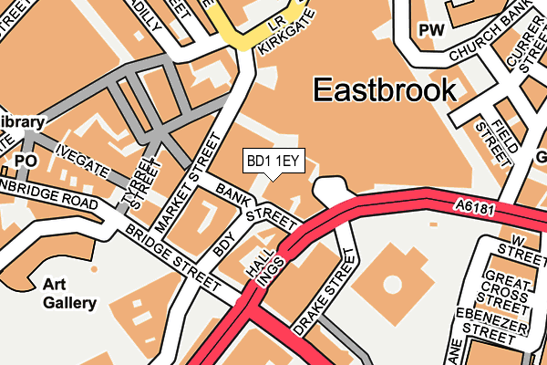
BD1 1EY is located in the City electoral ward, within the metropolitan district of Bradford and the English Parliamentary constituency of Bradford West. The Sub Integrated Care Board (ICB) Location is NHS West Yorkshire ICB - 36J and the police force is West Yorkshire. This postcode has been in use since January 1980.


GetTheData
Source: OS OpenMap – Local (Ordnance Survey)
Source: OS VectorMap District (Ordnance Survey)
Licence: Open Government Licence (requires attribution)
| Easting | 416498 |
| Northing | 433086 |
| Latitude | 53.793842 |
| Longitude | -1.751040 |
GetTheData
Source: Open Postcode Geo
Licence: Open Government Licence
| Country | England |
| Postcode District | BD1 |
➜ See where BD1 is on a map ➜ Where is Bradford? | |
GetTheData
Source: Land Registry Price Paid Data
Licence: Open Government Licence
Elevation or altitude of BD1 1EY as distance above sea level:
| Metres | Feet | |
|---|---|---|
| Elevation | 100m | 328ft |
Elevation is measured from the approximate centre of the postcode, to the nearest point on an OS contour line from OS Terrain 50, which has contour spacing of ten vertical metres.
➜ How high above sea level am I? Find the elevation of your current position using your device's GPS.
GetTheData
Source: Open Postcode Elevation
Licence: Open Government Licence
| Ward | City |
| Constituency | Bradford West |
GetTheData
Source: ONS Postcode Database
Licence: Open Government Licence
| Market St (Market Street) | Bradford City Centre | 77m |
| Market St (Market Street) | Bradford City Centre | 87m |
| Market St (Market Street) | Bradford City Centre | 89m |
| Broadway | Bradford City Centre | 93m |
| Market St (Market Street) | Bradford City Centre | 107m |
| Bradford Interchange Station | 0.3km |
| Bradford Forster Square Station | 0.4km |
| Frizinghall Station | 3.2km |
GetTheData
Source: NaPTAN
Licence: Open Government Licence
GetTheData
Source: ONS Postcode Database
Licence: Open Government Licence


➜ Get more ratings from the Food Standards Agency
GetTheData
Source: Food Standards Agency
Licence: FSA terms & conditions
| Last Collection | |||
|---|---|---|---|
| Location | Mon-Fri | Sat | Distance |
| Broadway House | 18:30 | 12:15 | 60m |
| 47 Hustlergate | 18:30 | 12:15 | 93m |
| Tyrell Street | 18:30 | 12:00 | 161m |
GetTheData
Source: Dracos
Licence: Creative Commons Attribution-ShareAlike
| Risk of BD1 1EY flooding from rivers and sea | Medium |
| ➜ BD1 1EY flood map | |
GetTheData
Source: Open Flood Risk by Postcode
Licence: Open Government Licence
The below table lists the International Territorial Level (ITL) codes (formerly Nomenclature of Territorial Units for Statistics (NUTS) codes) and Local Administrative Units (LAU) codes for BD1 1EY:
| ITL 1 Code | Name |
|---|---|
| TLE | Yorkshire and The Humber |
| ITL 2 Code | Name |
| TLE4 | West Yorkshire |
| ITL 3 Code | Name |
| TLE41 | Bradford |
| LAU 1 Code | Name |
| E08000032 | Bradford |
GetTheData
Source: ONS Postcode Directory
Licence: Open Government Licence
The below table lists the Census Output Area (OA), Lower Layer Super Output Area (LSOA), and Middle Layer Super Output Area (MSOA) for BD1 1EY:
| Code | Name | |
|---|---|---|
| OA | E00176110 | |
| LSOA | E01033690 | Bradford 039G |
| MSOA | E02002221 | Bradford 039 |
GetTheData
Source: ONS Postcode Directory
Licence: Open Government Licence
| BD1 1EE | Bank Street | 38m |
| BD1 1JB | Broadway | 100m |
| BD1 1NE | Market Street | 109m |
| BD1 1NS | Hustlergate | 124m |
| BD1 1RE | Hustlergate | 136m |
| BD1 1RX | Bridge Street | 156m |
| BD1 1RU | Tyrrel Street | 160m |
| BD1 1UG | Bank Street | 186m |
| BD1 1SR | Ivegate | 188m |
| BD1 3LW | Piccadilly | 189m |
GetTheData
Source: Open Postcode Geo; Land Registry Price Paid Data
Licence: Open Government Licence