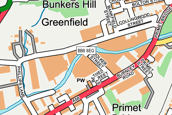
BB8 8EG is located in the Waterside & Horsfield electoral ward, within the local authority district of Pendle and the English Parliamentary constituency of Pendle. The Sub Integrated Care Board (ICB) Location is NHS Lancashire and South Cumbria ICB - 01A and the police force is Lancashire. This postcode has been in use since July 1995.


GetTheData
Source: OS OpenMap – Local (Ordnance Survey)
Source: OS VectorMap District (Ordnance Survey)
Licence: Open Government Licence (requires attribution)
| Easting | 387825 |
| Northing | 439548 |
| Latitude | 53.852033 |
| Longitude | -2.186562 |
GetTheData
Source: Open Postcode Geo
Licence: Open Government Licence
| Country | England |
| Postcode District | BB8 |
➜ See where BB8 is on a map ➜ Where is Colne? | |
GetTheData
Source: Land Registry Price Paid Data
Licence: Open Government Licence
Elevation or altitude of BB8 8EG as distance above sea level:
| Metres | Feet | |
|---|---|---|
| Elevation | 130m | 427ft |
Elevation is measured from the approximate centre of the postcode, to the nearest point on an OS contour line from OS Terrain 50, which has contour spacing of ten vertical metres.
➜ How high above sea level am I? Find the elevation of your current position using your device's GPS.
GetTheData
Source: Open Postcode Elevation
Licence: Open Government Licence
| Ward | Waterside & Horsfield |
| Constituency | Pendle |
GetTheData
Source: ONS Postcode Database
Licence: Open Government Licence
| Masons Mill (Burnley Road) | Primet | 139m |
| Phillips Lane (Burnley Road) | Primet | 144m |
| Masons Mill (Burnley Road) | Primet | 186m |
| End Street (Collingwood Street) | Bunker's Hill | 225m |
| Bunkers Hill (Cross Street West) | Bunker's Hill | 252m |
| Colne Station | 0.4km |
| Nelson Station | 2.6km |
| Brierfield Station | 4.5km |
GetTheData
Source: NaPTAN
Licence: Open Government Licence
GetTheData
Source: ONS Postcode Database
Licence: Open Government Licence


➜ Get more ratings from the Food Standards Agency
GetTheData
Source: Food Standards Agency
Licence: FSA terms & conditions
| Last Collection | |||
|---|---|---|---|
| Location | Mon-Fri | Sat | Distance |
| Crabtree Street | 16:00 | 11:00 | 639m |
| Broken Banks | 16:00 | 11:00 | 925m |
| Colne Post Office | 18:00 | 12:00 | 927m |
GetTheData
Source: Dracos
Licence: Creative Commons Attribution-ShareAlike
| Risk of BB8 8EG flooding from rivers and sea | Medium |
| ➜ BB8 8EG flood map | |
GetTheData
Source: Open Flood Risk by Postcode
Licence: Open Government Licence
The below table lists the International Territorial Level (ITL) codes (formerly Nomenclature of Territorial Units for Statistics (NUTS) codes) and Local Administrative Units (LAU) codes for BB8 8EG:
| ITL 1 Code | Name |
|---|---|
| TLD | North West (England) |
| ITL 2 Code | Name |
| TLD4 | Lancashire |
| ITL 3 Code | Name |
| TLD46 | East Lancashire |
| LAU 1 Code | Name |
| E07000122 | Pendle |
GetTheData
Source: ONS Postcode Directory
Licence: Open Government Licence
The below table lists the Census Output Area (OA), Lower Layer Super Output Area (LSOA), and Middle Layer Super Output Area (MSOA) for BB8 8EG:
| Code | Name | |
|---|---|---|
| OA | E00128044 | |
| LSOA | E01025226 | Pendle 007A |
| MSOA | E02005246 | Pendle 007 |
GetTheData
Source: ONS Postcode Directory
Licence: Open Government Licence
| BB8 8DQ | Primet Business Centre | 94m |
| BB8 9PD | Greenfield Road | 103m |
| BB8 8DR | Burnley Road | 106m |
| BB8 9PE | Greenfield Road | 115m |
| BB8 8DS | New Street | 125m |
| BB8 8DU | Wackersall Road | 134m |
| BB8 8DX | Cliff Street | 148m |
| BB8 8DT | Burnley Road | 150m |
| BB8 9PB | Hargreaves Street | 156m |
| BB8 9NY | Bankfield Street | 169m |
GetTheData
Source: Open Postcode Geo; Land Registry Price Paid Data
Licence: Open Government Licence