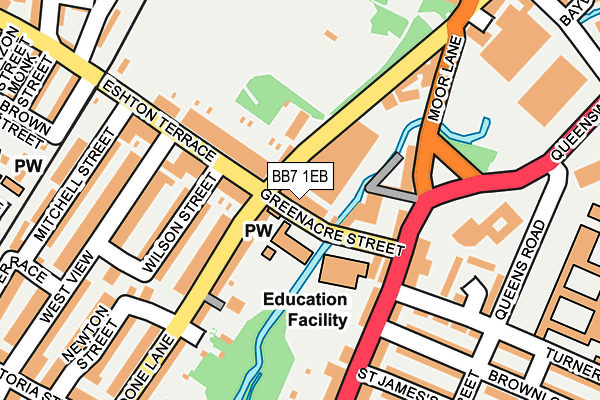
BB7 1EB lies on Greenacre Street in Clitheroe. BB7 1EB is located in the Primrose electoral ward, within the local authority district of Ribble Valley and the English Parliamentary constituency of Ribble Valley. The Sub Integrated Care Board (ICB) Location is NHS Lancashire and South Cumbria ICB - 01A and the police force is Lancashire. This postcode has been in use since January 1980.


GetTheData
Source: OS OpenMap – Local (Ordnance Survey)
Source: OS VectorMap District (Ordnance Survey)
Licence: Open Government Licence (requires attribution)
| Easting | 374163 |
| Northing | 441385 |
| Latitude | 53.868041 |
| Longitude | -2.394392 |
GetTheData
Source: Open Postcode Geo
Licence: Open Government Licence
| Street | Greenacre Street |
| Town/City | Clitheroe |
| Country | England |
| Postcode District | BB7 |
➜ See where BB7 is on a map ➜ Where is Clitheroe? | |
GetTheData
Source: Land Registry Price Paid Data
Licence: Open Government Licence
Elevation or altitude of BB7 1EB as distance above sea level:
| Metres | Feet | |
|---|---|---|
| Elevation | 70m | 230ft |
Elevation is measured from the approximate centre of the postcode, to the nearest point on an OS contour line from OS Terrain 50, which has contour spacing of ten vertical metres.
➜ How high above sea level am I? Find the elevation of your current position using your device's GPS.
GetTheData
Source: Open Postcode Elevation
Licence: Open Government Licence
| Ward | Primrose |
| Constituency | Ribble Valley |
GetTheData
Source: ONS Postcode Database
Licence: Open Government Licence
| Greenacre Street (Whalley Road) | Clitheroe Town Centre | 93m |
| Sainsburys (Moor Lane) | Clitheroe Town Centre | 123m |
| Queensway (Waterloo Road) | Clitheroe Town Centre | 152m |
| Turner Street | Little Moor | 179m |
| Commercial Hotel (Whalley Road) | Primrose | 181m |
| Clitheroe Station | 0.6km |
| Whalley Station | 5km |
GetTheData
Source: NaPTAN
Licence: Open Government Licence
GetTheData
Source: ONS Postcode Database
Licence: Open Government Licence


➜ Get more ratings from the Food Standards Agency
GetTheData
Source: Food Standards Agency
Licence: FSA terms & conditions
| Last Collection | |||
|---|---|---|---|
| Location | Mon-Fri | Sat | Distance |
| 2 Beverley Drive | 17:00 | 11:00 | 593m |
| 144 Chatburn Road | 16:00 | 11:30 | 1,460m |
| Station Whalley | 16:15 | 12:30 | 5,076m |
GetTheData
Source: Dracos
Licence: Creative Commons Attribution-ShareAlike
| Risk of BB7 1EB flooding from rivers and sea | Low |
| ➜ BB7 1EB flood map | |
GetTheData
Source: Open Flood Risk by Postcode
Licence: Open Government Licence
The below table lists the International Territorial Level (ITL) codes (formerly Nomenclature of Territorial Units for Statistics (NUTS) codes) and Local Administrative Units (LAU) codes for BB7 1EB:
| ITL 1 Code | Name |
|---|---|
| TLD | North West (England) |
| ITL 2 Code | Name |
| TLD4 | Lancashire |
| ITL 3 Code | Name |
| TLD45 | Mid Lancashire |
| LAU 1 Code | Name |
| E07000124 | Ribble Valley |
GetTheData
Source: ONS Postcode Directory
Licence: Open Government Licence
The below table lists the Census Output Area (OA), Lower Layer Super Output Area (LSOA), and Middle Layer Super Output Area (MSOA) for BB7 1EB:
| Code | Name | |
|---|---|---|
| OA | E00128601 | |
| LSOA | E01025338 | Ribble Valley 003D |
| MSOA | E02005272 | Ribble Valley 003 |
GetTheData
Source: ONS Postcode Directory
Licence: Open Government Licence
| BB7 1AW | Whalley Road | 73m |
| BB7 1BG | Woone Lane | 106m |
| BB7 1BQ | Eshton Terrace | 126m |
| BB7 1BH | Wilson Street | 168m |
| BB7 1EE | Whalley Road | 180m |
| BB7 1EQ | Turner Street | 184m |
| BB7 1EG | Brownlow Street | 210m |
| BB7 1HH | St James Street | 229m |
| BB7 1DG | West View | 230m |
| BB7 1DF | Mitchell Street | 258m |
GetTheData
Source: Open Postcode Geo; Land Registry Price Paid Data
Licence: Open Government Licence