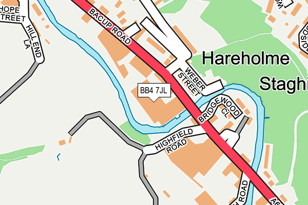
BB4 7JL is located in the Hareholme electoral ward, within the local authority district of Rossendale and the English Parliamentary constituency of Rossendale and Darwen. The Sub Integrated Care Board (ICB) Location is NHS Lancashire and South Cumbria ICB - 01A and the police force is Lancashire. This postcode has been in use since January 1995.


GetTheData
Source: OS OpenMap – Local (Ordnance Survey)
Source: OS VectorMap District (Ordnance Survey)
Licence: Open Government Licence (requires attribution)
| Easting | 382550 |
| Northing | 422226 |
| Latitude | 53.696179 |
| Longitude | -2.265760 |
GetTheData
Source: Open Postcode Geo
Licence: Open Government Licence
| Country | England |
| Postcode District | BB4 |
➜ See where BB4 is on a map ➜ Where is Rawtenstall? | |
GetTheData
Source: Land Registry Price Paid Data
Licence: Open Government Licence
Elevation or altitude of BB4 7JL as distance above sea level:
| Metres | Feet | |
|---|---|---|
| Elevation | 180m | 591ft |
Elevation is measured from the approximate centre of the postcode, to the nearest point on an OS contour line from OS Terrain 50, which has contour spacing of ten vertical metres.
➜ How high above sea level am I? Find the elevation of your current position using your device's GPS.
GetTheData
Source: Open Postcode Elevation
Licence: Open Government Licence
| Ward | Hareholme |
| Constituency | Rossendale And Darwen |
GetTheData
Source: ONS Postcode Database
Licence: Open Government Licence
| Hareholme Lane (Bacup Road) | Hareholme | 51m |
| Hareholme Lane (Bacup Road) | Hareholme | 83m |
| Lench Road (Bacup Road) | Staghills | 267m |
| Lench Road (Bacup Road) | Waterfoot | 353m |
| North Road (Bacup Road) | Cloughfold | 373m |
GetTheData
Source: NaPTAN
Licence: Open Government Licence
Estimated total energy consumption in BB4 7JL by fuel type, 2015.
| Consumption (kWh) | 102,697 |
|---|---|
| Meter count | 9 |
| Mean (kWh/meter) | 11,411 |
| Median (kWh/meter) | 11,970 |
GetTheData
Source: Postcode level gas estimates: 2015 (experimental)
Source: Postcode level electricity estimates: 2015 (experimental)
Licence: Open Government Licence
GetTheData
Source: ONS Postcode Database
Licence: Open Government Licence


➜ Get more ratings from the Food Standards Agency
GetTheData
Source: Food Standards Agency
Licence: FSA terms & conditions
| Last Collection | |||
|---|---|---|---|
| Location | Mon-Fri | Sat | Distance |
| Helmshore Post Office | 16:45 | 11:45 | 505m |
| Newchurch Road | 17:30 | 11:30 | 600m |
| Rossendale Delivery Office | 17:45 | 13:00 | 1,375m |
GetTheData
Source: Dracos
Licence: Creative Commons Attribution-ShareAlike
| Risk of BB4 7JL flooding from rivers and sea | Medium |
| ➜ BB4 7JL flood map | |
GetTheData
Source: Open Flood Risk by Postcode
Licence: Open Government Licence
The below table lists the International Territorial Level (ITL) codes (formerly Nomenclature of Territorial Units for Statistics (NUTS) codes) and Local Administrative Units (LAU) codes for BB4 7JL:
| ITL 1 Code | Name |
|---|---|
| TLD | North West (England) |
| ITL 2 Code | Name |
| TLD4 | Lancashire |
| ITL 3 Code | Name |
| TLD46 | East Lancashire |
| LAU 1 Code | Name |
| E07000125 | Rossendale |
GetTheData
Source: ONS Postcode Directory
Licence: Open Government Licence
The below table lists the Census Output Area (OA), Lower Layer Super Output Area (LSOA), and Middle Layer Super Output Area (MSOA) for BB4 7JL:
| Code | Name | |
|---|---|---|
| OA | E00128772 | |
| LSOA | E01025371 | Rossendale 010A |
| MSOA | E02006884 | Rossendale 010 |
GetTheData
Source: ONS Postcode Directory
Licence: Open Government Licence
| BB4 7JJ | Bacup Road | 70m |
| BB4 7JY | Weber Street | 98m |
| BB4 7JX | Brookland Street | 125m |
| BB4 7AP | Bridgewood Close | 141m |
| BB4 7JR | Rostrons Buildings | 147m |
| BB4 7JP | Gilbert Street | 149m |
| BB4 7JZ | Hareholme Lane | 154m |
| BB4 7LW | Heys Close | 242m |
| BB4 7PS | Upper Ash Mount | 273m |
| BB4 7JH | Lench Road | 296m |
GetTheData
Source: Open Postcode Geo; Land Registry Price Paid Data
Licence: Open Government Licence