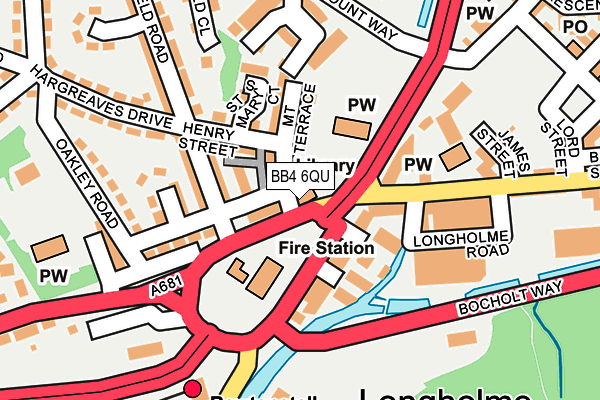
BB4 6QU is located in the Longholme electoral ward, within the local authority district of Rossendale and the English Parliamentary constituency of Rossendale and Darwen. The Sub Integrated Care Board (ICB) Location is NHS Lancashire and South Cumbria ICB - 01A and the police force is Lancashire. This postcode has been in use since January 1980.


GetTheData
Source: OS OpenMap – Local (Ordnance Survey)
Source: OS VectorMap District (Ordnance Survey)
Licence: Open Government Licence (requires attribution)
| Easting | 381045 |
| Northing | 422727 |
| Latitude | 53.700630 |
| Longitude | -2.288584 |
GetTheData
Source: Open Postcode Geo
Licence: Open Government Licence
| Country | England |
| Postcode District | BB4 |
➜ See where BB4 is on a map ➜ Where is Rawtenstall? | |
GetTheData
Source: Land Registry Price Paid Data
Licence: Open Government Licence
Elevation or altitude of BB4 6QU as distance above sea level:
| Metres | Feet | |
|---|---|---|
| Elevation | 170m | 558ft |
Elevation is measured from the approximate centre of the postcode, to the nearest point on an OS contour line from OS Terrain 50, which has contour spacing of ten vertical metres.
➜ How high above sea level am I? Find the elevation of your current position using your device's GPS.
GetTheData
Source: Open Postcode Elevation
Licence: Open Government Licence
| Ward | Longholme |
| Constituency | Rossendale And Darwen |
GetTheData
Source: ONS Postcode Database
Licence: Open Government Licence
| Fire Station (Haslingden Road) | Rawtenstall | 106m |
| Railway Station (Bury Road) | Rawtenstall | 197m |
| Bus Station (Bacup Road) | Rawtenstall | 201m |
| Bank Street | Rawtenstall | 234m |
| Magistrates Court (Haslingden Road) | Rawtenstall | 243m |
| Rawtenstall (East Lancashire Railway) | Longholme | 269m |
GetTheData
Source: NaPTAN
Licence: Open Government Licence
GetTheData
Source: ONS Postcode Database
Licence: Open Government Licence


➜ Get more ratings from the Food Standards Agency
GetTheData
Source: Food Standards Agency
Licence: FSA terms & conditions
| Last Collection | |||
|---|---|---|---|
| Location | Mon-Fri | Sat | Distance |
| Railway Station | 16:45 | 12:30 | 208m |
| Rossendale Delivery Office | 17:45 | 13:00 | 317m |
| Helmshore Post Office | 16:45 | 11:45 | 1,314m |
GetTheData
Source: Dracos
Licence: Creative Commons Attribution-ShareAlike
The below table lists the International Territorial Level (ITL) codes (formerly Nomenclature of Territorial Units for Statistics (NUTS) codes) and Local Administrative Units (LAU) codes for BB4 6QU:
| ITL 1 Code | Name |
|---|---|
| TLD | North West (England) |
| ITL 2 Code | Name |
| TLD4 | Lancashire |
| ITL 3 Code | Name |
| TLD46 | East Lancashire |
| LAU 1 Code | Name |
| E07000125 | Rossendale |
GetTheData
Source: ONS Postcode Directory
Licence: Open Government Licence
The below table lists the Census Output Area (OA), Lower Layer Super Output Area (LSOA), and Middle Layer Super Output Area (MSOA) for BB4 6QU:
| Code | Name | |
|---|---|---|
| OA | E00128840 | |
| LSOA | E01033281 | Rossendale 004G |
| MSOA | E02005281 | Rossendale 004 |
GetTheData
Source: ONS Postcode Directory
Licence: Open Government Licence
| BB4 8SQ | St Marys Terrace | 45m |
| BB4 8SH | St Marys Place | 61m |
| BB4 6AA | Bury Road | 67m |
| BB4 8SJ | Henry Street | 82m |
| BB4 6AD | Queen Street | 93m |
| BB4 6AF | Parramatta Street | 96m |
| BB4 8SF | Mount Terrace | 100m |
| BB4 8SG | Derby Terrace | 103m |
| BB4 8SL | Schofield Road | 114m |
| BB4 7NG | Bacup Road | 122m |
GetTheData
Source: Open Postcode Geo; Land Registry Price Paid Data
Licence: Open Government Licence