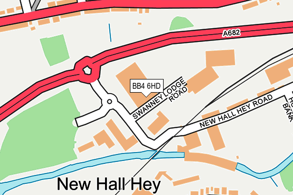
BB4 6HD is located in the Longholme electoral ward, within the local authority district of Rossendale and the English Parliamentary constituency of Rossendale and Darwen. The Sub Integrated Care Board (ICB) Location is NHS Lancashire and South Cumbria ICB - 01A and the police force is Lancashire. This postcode has been in use since July 2017.


GetTheData
Source: OS OpenMap – Local (Ordnance Survey)
Source: OS VectorMap District (Ordnance Survey)
Licence: Open Government Licence (requires attribution)
| Easting | 380472 |
| Northing | 422435 |
| Latitude | 53.697999 |
| Longitude | -2.297243 |
GetTheData
Source: Open Postcode Geo
Licence: Open Government Licence
| Country | England |
| Postcode District | BB4 |
➜ See where BB4 is on a map ➜ Where is Rawtenstall? | |
GetTheData
Source: Land Registry Price Paid Data
Licence: Open Government Licence
| Ward | Longholme |
| Constituency | Rossendale And Darwen |
GetTheData
Source: ONS Postcode Database
Licence: Open Government Licence
| Business Village (New Hall Hey Road) | Rawtenstall | 79m |
| Business Village (New Hall Hey Road) | Rawtenstall | 113m |
| Whitaker Park (Haslingden Road) | Rawtenstall | 153m |
| Mount Street (Haslingden Road) | Rawtenstall | 167m |
| Whitaker Park (Haslingden Road) | Rawtenstall | 173m |
| Rawtenstall (East Lancashire Railway) | Longholme | 437m |
GetTheData
Source: NaPTAN
Licence: Open Government Licence
GetTheData
Source: ONS Postcode Database
Licence: Open Government Licence


➜ Get more ratings from the Food Standards Agency
GetTheData
Source: Food Standards Agency
Licence: FSA terms & conditions
| Last Collection | |||
|---|---|---|---|
| Location | Mon-Fri | Sat | Distance |
| Railway Station | 16:45 | 12:30 | 491m |
| Rossendale Delivery Office | 17:45 | 13:00 | 960m |
| Sidmouth Avenue | 17:30 | 12:15 | 1,252m |
GetTheData
Source: Dracos
Licence: Creative Commons Attribution-ShareAlike
| Risk of BB4 6HD flooding from rivers and sea | Low |
| ➜ BB4 6HD flood map | |
GetTheData
Source: Open Flood Risk by Postcode
Licence: Open Government Licence
The below table lists the International Territorial Level (ITL) codes (formerly Nomenclature of Territorial Units for Statistics (NUTS) codes) and Local Administrative Units (LAU) codes for BB4 6HD:
| ITL 1 Code | Name |
|---|---|
| TLD | North West (England) |
| ITL 2 Code | Name |
| TLD4 | Lancashire |
| ITL 3 Code | Name |
| TLD46 | East Lancashire |
| LAU 1 Code | Name |
| E07000125 | Rossendale |
GetTheData
Source: ONS Postcode Directory
Licence: Open Government Licence
The below table lists the Census Output Area (OA), Lower Layer Super Output Area (LSOA), and Middle Layer Super Output Area (MSOA) for BB4 6HD:
| Code | Name | |
|---|---|---|
| OA | E00128838 | |
| LSOA | E01033281 | Rossendale 004G |
| MSOA | E02005281 | Rossendale 004 |
GetTheData
Source: ONS Postcode Directory
Licence: Open Government Licence
| BB4 6RE | Haslingden Road | 148m |
| BB4 6RG | Hayes Buildings | 166m |
| BB4 6RH | Fieldings Buildings | 177m |
| BB4 6RL | Whitaker Green | 208m |
| BB4 6HL | New Hall Hey Road | 220m |
| BB4 6RT | Mount Pleasant | 226m |
| BB4 6HP | Railway Terrace | 233m |
| BB4 6RJ | Mount Street | 241m |
| BB4 6RW | Willow Tree Avenue | 305m |
| BB4 6SE | Oakley Street | 306m |
GetTheData
Source: Open Postcode Geo; Land Registry Price Paid Data
Licence: Open Government Licence