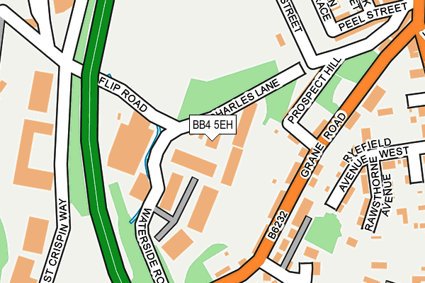
BB4 5EH is located in the Worsley electoral ward, within the local authority district of Rossendale and the English Parliamentary constituency of Hyndburn. The Sub Integrated Care Board (ICB) Location is NHS Lancashire and South Cumbria ICB - 01A and the police force is Lancashire. This postcode has been in use since June 2000.


GetTheData
Source: OS OpenMap – Local (Ordnance Survey)
Source: OS VectorMap District (Ordnance Survey)
Licence: Open Government Licence (requires attribution)
| Easting | 378280 |
| Northing | 422880 |
| Latitude | 53.701896 |
| Longitude | -2.330474 |
GetTheData
Source: Open Postcode Geo
Licence: Open Government Licence
| Country | England |
| Postcode District | BB4 |
➜ See where BB4 is on a map ➜ Where is Haslingden? | |
GetTheData
Source: Land Registry Price Paid Data
Licence: Open Government Licence
Elevation or altitude of BB4 5EH as distance above sea level:
| Metres | Feet | |
|---|---|---|
| Elevation | 200m | 656ft |
Elevation is measured from the approximate centre of the postcode, to the nearest point on an OS contour line from OS Terrain 50, which has contour spacing of ten vertical metres.
➜ How high above sea level am I? Find the elevation of your current position using your device's GPS.
GetTheData
Source: Open Postcode Elevation
Licence: Open Government Licence
| Ward | Worsley |
| Constituency | Hyndburn |
GetTheData
Source: ONS Postcode Database
Licence: Open Government Licence
| Highfield Street (Grane Road) | Haslingden | 140m |
| Highfield Street (Grane Road) | Haslingden | 142m |
| Bowling Green (Helmshore Road) | Haslingden | 336m |
| East Bank Ave (Helmshore Road) | Haslingden | 339m |
| East Bank Ave (Helmshore Road) | Haslingden | 362m |
GetTheData
Source: NaPTAN
Licence: Open Government Licence
| Median download speed | 57.1Mbps |
| Average download speed | 48.5Mbps |
| Maximum download speed | 71.92Mbps |
| Median upload speed | 13.5Mbps |
| Average upload speed | 12.3Mbps |
| Maximum upload speed | 20.00Mbps |
GetTheData
Source: Ofcom
Licence: Ofcom Terms of Use (requires attribution)
GetTheData
Source: ONS Postcode Database
Licence: Open Government Licence


➜ Get more ratings from the Food Standards Agency
GetTheData
Source: Food Standards Agency
Licence: FSA terms & conditions
| Last Collection | |||
|---|---|---|---|
| Location | Mon-Fri | Sat | Distance |
| Haslingden Post Office | 17:15 | 12:00 | 428m |
| Sidmouth Avenue | 17:30 | 12:15 | 1,007m |
| Railway Station | 16:45 | 12:30 | 2,692m |
GetTheData
Source: Dracos
Licence: Creative Commons Attribution-ShareAlike
The below table lists the International Territorial Level (ITL) codes (formerly Nomenclature of Territorial Units for Statistics (NUTS) codes) and Local Administrative Units (LAU) codes for BB4 5EH:
| ITL 1 Code | Name |
|---|---|
| TLD | North West (England) |
| ITL 2 Code | Name |
| TLD4 | Lancashire |
| ITL 3 Code | Name |
| TLD46 | East Lancashire |
| LAU 1 Code | Name |
| E07000125 | Rossendale |
GetTheData
Source: ONS Postcode Directory
Licence: Open Government Licence
The below table lists the Census Output Area (OA), Lower Layer Super Output Area (LSOA), and Middle Layer Super Output Area (MSOA) for BB4 5EH:
| Code | Name | |
|---|---|---|
| OA | E00128889 | |
| LSOA | E01025397 | Rossendale 002F |
| MSOA | E02005279 | Rossendale 002 |
GetTheData
Source: ONS Postcode Directory
Licence: Open Government Licence
| BB4 5EQ | Charles Lane | 23m |
| BB4 5EY | Whittle Street | 120m |
| BB4 5ED | Grane Road | 122m |
| BB4 5EF | Prospect Hill | 157m |
| BB4 4BQ | Ryefield Court | 174m |
| BB4 5EB | Grane Road | 192m |
| BB4 5HB | Grane Park | 222m |
| BB4 4BN | Rawsthorne Avenue | 232m |
| BB4 4BL | Ryefield Avenue West | 246m |
| BB4 5EX | Highfield Street | 265m |
GetTheData
Source: Open Postcode Geo; Land Registry Price Paid Data
Licence: Open Government Licence