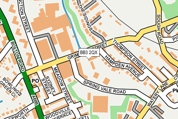
BB3 2QX lies on Grimshaw Street in Darwen. BB3 2QX is located in the Darwen South electoral ward, within the unitary authority of Blackburn with Darwen and the English Parliamentary constituency of Rossendale and Darwen. The Sub Integrated Care Board (ICB) Location is NHS Lancashire and South Cumbria ICB - 00Q and the police force is Lancashire. This postcode has been in use since July 2010.


GetTheData
Source: OS OpenMap – Local (Ordnance Survey)
Source: OS VectorMap District (Ordnance Survey)
Licence: Open Government Licence (requires attribution)
| Easting | 369817 |
| Northing | 421106 |
| Latitude | 53.685545 |
| Longitude | -2.458486 |
GetTheData
Source: Open Postcode Geo
Licence: Open Government Licence
| Street | Grimshaw Street |
| Town/City | Darwen |
| Country | England |
| Postcode District | BB3 |
➜ See where BB3 is on a map ➜ Where is Darwen? | |
GetTheData
Source: Land Registry Price Paid Data
Licence: Open Government Licence
Elevation or altitude of BB3 2QX as distance above sea level:
| Metres | Feet | |
|---|---|---|
| Elevation | 190m | 623ft |
Elevation is measured from the approximate centre of the postcode, to the nearest point on an OS contour line from OS Terrain 50, which has contour spacing of ten vertical metres.
➜ How high above sea level am I? Find the elevation of your current position using your device's GPS.
GetTheData
Source: Open Postcode Elevation
Licence: Open Government Licence
| Ward | Darwen South |
| Constituency | Rossendale And Darwen |
GetTheData
Source: ONS Postcode Database
Licence: Open Government Licence
| Epworth Street (Melbourne Street) | Darwen | 229m |
| Watery Lane | Darwen | 234m |
| Watery Lane | Darwen | 246m |
| Mayfield Flats (Bolton Road) | Darwen | 250m |
| Mayfield Flats (Bolton Road) | Darwen | 258m |
| Darwen Station | 1.5km |
| Entwistle Station | 4.4km |
GetTheData
Source: NaPTAN
Licence: Open Government Licence
| Median download speed | 77.0Mbps |
| Average download speed | 56.8Mbps |
| Maximum download speed | 80.00Mbps |
| Median upload speed | 20.0Mbps |
| Average upload speed | 14.2Mbps |
| Maximum upload speed | 20.00Mbps |
GetTheData
Source: Ofcom
Licence: Ofcom Terms of Use (requires attribution)
GetTheData
Source: ONS Postcode Database
Licence: Open Government Licence


➜ Get more ratings from the Food Standards Agency
GetTheData
Source: Food Standards Agency
Licence: FSA terms & conditions
| Last Collection | |||
|---|---|---|---|
| Location | Mon-Fri | Sat | Distance |
| 68 Birch Hall Avenue | 16:30 | 11:00 | 1,144m |
| Royal Arms | 12:00 | 09:00 | 3,343m |
| Entwistle Station | 16:45 | 11:35 | 4,407m |
GetTheData
Source: Dracos
Licence: Creative Commons Attribution-ShareAlike
The below table lists the International Territorial Level (ITL) codes (formerly Nomenclature of Territorial Units for Statistics (NUTS) codes) and Local Administrative Units (LAU) codes for BB3 2QX:
| ITL 1 Code | Name |
|---|---|
| TLD | North West (England) |
| ITL 2 Code | Name |
| TLD4 | Lancashire |
| ITL 3 Code | Name |
| TLD41 | Blackburn with Darwen |
| LAU 1 Code | Name |
| E06000008 | Blackburn with Darwen |
GetTheData
Source: ONS Postcode Directory
Licence: Open Government Licence
The below table lists the Census Output Area (OA), Lower Layer Super Output Area (LSOA), and Middle Layer Super Output Area (MSOA) for BB3 2QX:
| Code | Name | |
|---|---|---|
| OA | E00063601 | |
| LSOA | E01012616 | Blackburn with Darwen 017C |
| MSOA | E02002631 | Blackburn with Darwen 017 |
GetTheData
Source: ONS Postcode Directory
Licence: Open Government Licence
| BB3 2HB | Hampden Avenue | 105m |
| BB3 2QL | Meadow Street | 136m |
| BB3 2QJ | Grimshaw Street | 141m |
| BB3 2EY | Thompson Street | 156m |
| BB3 2QW | Sydney Street | 164m |
| BB3 2BD | The Sidings | 173m |
| BB3 2QN | Melbourne Street | 174m |
| BB3 2QP | Auckland Street | 188m |
| BB3 2JH | Woodville Terrace | 191m |
| BB3 2JJ | Portland Street | 203m |
GetTheData
Source: Open Postcode Geo; Land Registry Price Paid Data
Licence: Open Government Licence