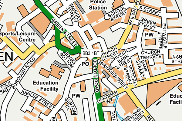
BB3 1BT is located in the Darwen West electoral ward, within the unitary authority of Blackburn with Darwen and the English Parliamentary constituency of Rossendale and Darwen. The Sub Integrated Care Board (ICB) Location is NHS Lancashire and South Cumbria ICB - 00Q and the police force is Lancashire. This postcode has been in use since January 1980.


GetTheData
Source: OS OpenMap – Local (Ordnance Survey)
Source: OS VectorMap District (Ordnance Survey)
Licence: Open Government Licence (requires attribution)
| Easting | 369231 |
| Northing | 422158 |
| Latitude | 53.694966 |
| Longitude | -2.467463 |
GetTheData
Source: Open Postcode Geo
Licence: Open Government Licence
| Country | England |
| Postcode District | BB3 |
➜ See where BB3 is on a map ➜ Where is Darwen? | |
GetTheData
Source: Land Registry Price Paid Data
Licence: Open Government Licence
Elevation or altitude of BB3 1BT as distance above sea level:
| Metres | Feet | |
|---|---|---|
| Elevation | 160m | 525ft |
Elevation is measured from the approximate centre of the postcode, to the nearest point on an OS contour line from OS Terrain 50, which has contour spacing of ten vertical metres.
➜ How high above sea level am I? Find the elevation of your current position using your device's GPS.
GetTheData
Source: Open Postcode Elevation
Licence: Open Government Licence
| Ward | Darwen West |
| Constituency | Rossendale And Darwen |
GetTheData
Source: ONS Postcode Database
Licence: Open Government Licence
| Town Centre (Croft Street) | Darwen | 65m |
| Town Centre (Croft Street) | Darwen | 72m |
| Town Centre (Croft Street) | Darwen | 77m |
| Bus Station Set Down (Croft Street) | Darwen | 81m |
| Circus (Market Street) | Darwen | 94m |
| Darwen Station | 0.4km |
| Mill Hill (Lancs) Station | 5km |
| Cherry Tree Station | 5.4km |
GetTheData
Source: NaPTAN
Licence: Open Government Licence
GetTheData
Source: ONS Postcode Database
Licence: Open Government Licence


➜ Get more ratings from the Food Standards Agency
GetTheData
Source: Food Standards Agency
Licence: FSA terms & conditions
| Last Collection | |||
|---|---|---|---|
| Location | Mon-Fri | Sat | Distance |
| 68 Birch Hall Avenue | 16:30 | 11:00 | 75m |
| Royal Arms | 12:00 | 09:00 | 2,801m |
| Moorgate | 16:15 | 11:15 | 4,307m |
GetTheData
Source: Dracos
Licence: Creative Commons Attribution-ShareAlike
The below table lists the International Territorial Level (ITL) codes (formerly Nomenclature of Territorial Units for Statistics (NUTS) codes) and Local Administrative Units (LAU) codes for BB3 1BT:
| ITL 1 Code | Name |
|---|---|
| TLD | North West (England) |
| ITL 2 Code | Name |
| TLD4 | Lancashire |
| ITL 3 Code | Name |
| TLD41 | Blackburn with Darwen |
| LAU 1 Code | Name |
| E06000008 | Blackburn with Darwen |
GetTheData
Source: ONS Postcode Directory
Licence: Open Government Licence
The below table lists the Census Output Area (OA), Lower Layer Super Output Area (LSOA), and Middle Layer Super Output Area (MSOA) for BB3 1BT:
| Code | Name | |
|---|---|---|
| OA | E00171883 | |
| LSOA | E01012654 | Blackburn with Darwen 016D |
| MSOA | E02002630 | Blackburn with Darwen 016 |
GetTheData
Source: ONS Postcode Directory
Licence: Open Government Licence
| BB3 1BN | Market Street | 37m |
| BB3 1DJ | Foundry Street | 66m |
| BB3 1BU | Belgrave Square | 81m |
| BB3 2AA | Bridge Street | 91m |
| BB3 1PL | Borough Road | 96m |
| BB3 2RE | Church Street | 97m |
| BB3 2UX | Belgrave Road | 99m |
| BB3 1PS | Market Street | 111m |
| BB3 1BE | School Street | 135m |
| BB3 1AZ | Market Street | 139m |
GetTheData
Source: Open Postcode Geo; Land Registry Price Paid Data
Licence: Open Government Licence