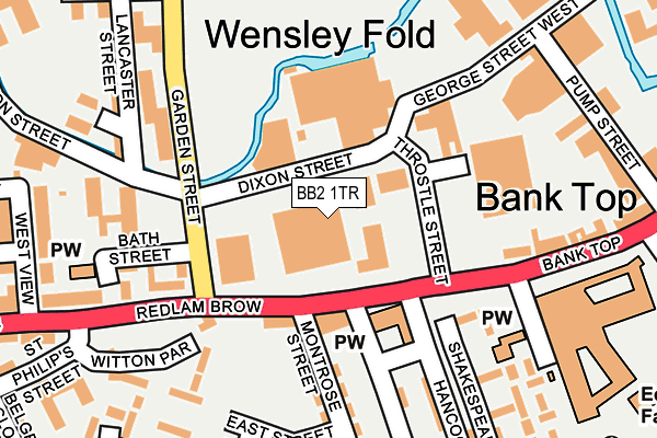
BB2 1TR is located in the Blackburn Central electoral ward, within the unitary authority of Blackburn with Darwen and the English Parliamentary constituency of Blackburn. The Sub Integrated Care Board (ICB) Location is NHS Lancashire and South Cumbria ICB - 00Q and the police force is Lancashire. This postcode has been in use since June 1981.


GetTheData
Source: OS OpenMap – Local (Ordnance Survey)
Source: OS VectorMap District (Ordnance Survey)
Licence: Open Government Licence (requires attribution)
| Easting | 367231 |
| Northing | 427624 |
| Latitude | 53.743971 |
| Longitude | -2.498332 |
GetTheData
Source: Open Postcode Geo
Licence: Open Government Licence
| Country | England |
| Postcode District | BB2 |
➜ See where BB2 is on a map ➜ Where is Blackburn? | |
GetTheData
Source: Land Registry Price Paid Data
Licence: Open Government Licence
Elevation or altitude of BB2 1TR as distance above sea level:
| Metres | Feet | |
|---|---|---|
| Elevation | 100m | 328ft |
Elevation is measured from the approximate centre of the postcode, to the nearest point on an OS contour line from OS Terrain 50, which has contour spacing of ten vertical metres.
➜ How high above sea level am I? Find the elevation of your current position using your device's GPS.
GetTheData
Source: Open Postcode Elevation
Licence: Open Government Licence
| Ward | Blackburn Central |
| Constituency | Blackburn |
GetTheData
Source: ONS Postcode Database
Licence: Open Government Licence
| Garden Street | Bank Top | 101m |
| The Griffin (Bank Top) | Wensley Fold | 142m |
| Garden Street | Bank Top | 145m |
| The Griffin (Bank Top) | Wensley Fold | 161m |
| Baldwin Street (Hancock Street) | Bank Top | 224m |
| Mill Hill (Lancs) Station | 1km |
| Blackburn Station | 1.3km |
| Cherry Tree Station | 1.8km |
GetTheData
Source: NaPTAN
Licence: Open Government Licence
GetTheData
Source: ONS Postcode Database
Licence: Open Government Licence


➜ Get more ratings from the Food Standards Agency
GetTheData
Source: Food Standards Agency
Licence: FSA terms & conditions
| Last Collection | |||
|---|---|---|---|
| Location | Mon-Fri | Sat | Distance |
| 3 Saunders Road | 17:30 | 13:00 | 253m |
| Whalley Banks Post Office | 17:30 | 12:45 | 407m |
| Dukes Brow | 16:30 | 12:00 | 782m |
GetTheData
Source: Dracos
Licence: Creative Commons Attribution-ShareAlike
| Risk of BB2 1TR flooding from rivers and sea | Low |
| ➜ BB2 1TR flood map | |
GetTheData
Source: Open Flood Risk by Postcode
Licence: Open Government Licence
The below table lists the International Territorial Level (ITL) codes (formerly Nomenclature of Territorial Units for Statistics (NUTS) codes) and Local Administrative Units (LAU) codes for BB2 1TR:
| ITL 1 Code | Name |
|---|---|
| TLD | North West (England) |
| ITL 2 Code | Name |
| TLD4 | Lancashire |
| ITL 3 Code | Name |
| TLD41 | Blackburn with Darwen |
| LAU 1 Code | Name |
| E06000008 | Blackburn with Darwen |
GetTheData
Source: ONS Postcode Directory
Licence: Open Government Licence
The below table lists the Census Output Area (OA), Lower Layer Super Output Area (LSOA), and Middle Layer Super Output Area (MSOA) for BB2 1TR:
| Code | Name | |
|---|---|---|
| OA | E00063806 | |
| LSOA | E01012655 | Blackburn with Darwen 006E |
| MSOA | E02002620 | Blackburn with Darwen 006 |
GetTheData
Source: ONS Postcode Directory
Licence: Open Government Licence
| BB2 1TN | Bank Top | 159m |
| BB2 1UA | Lancaster Street | 163m |
| BB2 1UJ | Bath Street | 164m |
| BB2 1UE | Balfour Street | 187m |
| BB2 1QD | Wensley Road | 218m |
| BB2 1QA | Wensley Road | 229m |
| BB2 1XH | Hamlet Close | 229m |
| BB2 2SH | West View | 238m |
| BB2 1QE | Bent Gap Lane | 239m |
| BB2 1UL | Redlam | 244m |
GetTheData
Source: Open Postcode Geo; Land Registry Price Paid Data
Licence: Open Government Licence