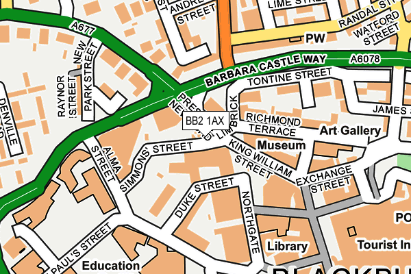
BB2 1AX lies on Simmons Street in Blackburn. BB2 1AX is located in the Blackburn Central electoral ward, within the unitary authority of Blackburn with Darwen and the English Parliamentary constituency of Blackburn. The Sub Integrated Care Board (ICB) Location is NHS Lancashire and South Cumbria ICB - 00Q and the police force is Lancashire. This postcode has been in use since January 1980.


GetTheData
Source: OS OpenMap – Local (Ordnance Survey)
Source: OS VectorMap District (Ordnance Survey)
Licence: Open Government Licence (requires attribution)
| Easting | 368000 |
| Northing | 428351 |
| Latitude | 53.750552 |
| Longitude | -2.486748 |
GetTheData
Source: Open Postcode Geo
Licence: Open Government Licence
| Street | Simmons Street |
| Town/City | Blackburn |
| Country | England |
| Postcode District | BB2 |
➜ See where BB2 is on a map ➜ Where is Blackburn? | |
GetTheData
Source: Land Registry Price Paid Data
Licence: Open Government Licence
Elevation or altitude of BB2 1AX as distance above sea level:
| Metres | Feet | |
|---|---|---|
| Elevation | 120m | 394ft |
Elevation is measured from the approximate centre of the postcode, to the nearest point on an OS contour line from OS Terrain 50, which has contour spacing of ten vertical metres.
➜ How high above sea level am I? Find the elevation of your current position using your device's GPS.
GetTheData
Source: Open Postcode Elevation
Licence: Open Government Licence
| Ward | Blackburn Central |
| Constituency | Blackburn |
GetTheData
Source: ONS Postcode Database
Licence: Open Government Licence
2A, SIMMONS STREET, BLACKBURN, BB2 1AX 2010 17 SEP £85,000 |
2A, SIMMONS STREET, BLACKBURN, BB2 1AX 2001 12 OCT £55,000 |
GetTheData
Source: HM Land Registry Price Paid Data
Licence: Contains HM Land Registry data © Crown copyright and database right 2025. This data is licensed under the Open Government Licence v3.0.
| Suddell Cross (Preston New Road) | Blackburn | 24m |
| Strawberry Bank (Preston New Road) | Blackburn | 121m |
| Alma Street (Simmons Street) | Blackburn Town Centre | 130m |
| Alma Street (Blakey Moor) | Blackburn Town Centre | 151m |
| Limbrick | Blackburn | 157m |
| Blackburn Station | 0.7km |
| Mill Hill (Lancs) Station | 1.9km |
| Cherry Tree Station | 2.9km |
GetTheData
Source: NaPTAN
Licence: Open Government Licence
GetTheData
Source: ONS Postcode Database
Licence: Open Government Licence


➜ Get more ratings from the Food Standards Agency
GetTheData
Source: Food Standards Agency
Licence: FSA terms & conditions
| Last Collection | |||
|---|---|---|---|
| Location | Mon-Fri | Sat | Distance |
| Technical College | 16:00 | 11:15 | 211m |
| Church Street | 16:30 | 13:00 | 437m |
| 91 Preston New Road | 17:15 | 13:00 | 442m |
GetTheData
Source: Dracos
Licence: Creative Commons Attribution-ShareAlike
The below table lists the International Territorial Level (ITL) codes (formerly Nomenclature of Territorial Units for Statistics (NUTS) codes) and Local Administrative Units (LAU) codes for BB2 1AX:
| ITL 1 Code | Name |
|---|---|
| TLD | North West (England) |
| ITL 2 Code | Name |
| TLD4 | Lancashire |
| ITL 3 Code | Name |
| TLD41 | Blackburn with Darwen |
| LAU 1 Code | Name |
| E06000008 | Blackburn with Darwen |
GetTheData
Source: ONS Postcode Directory
Licence: Open Government Licence
The below table lists the Census Output Area (OA), Lower Layer Super Output Area (LSOA), and Middle Layer Super Output Area (MSOA) for BB2 1AX:
| Code | Name | |
|---|---|---|
| OA | E00063793 | |
| LSOA | E01012656 | Blackburn with Darwen 005C |
| MSOA | E02002619 | Blackburn with Darwen 005 |
GetTheData
Source: ONS Postcode Directory
Licence: Open Government Licence
| BB2 1AR | Preston New Road | 13m |
| BB2 1AW | Preston New Road | 40m |
| BB1 7EB | Sudell Cross | 57m |
| BB1 7AT | Richmond Terrace | 74m |
| BB2 1AA | Northgate | 91m |
| BB2 6AA | Strawberry Bank | 105m |
| BB1 7BD | Richmond Terrace | 111m |
| BB1 7DT | King William Street | 112m |
| BB1 8AA | Limbrick | 131m |
| BB1 7BQ | Richmond Terrace | 132m |
GetTheData
Source: Open Postcode Geo; Land Registry Price Paid Data
Licence: Open Government Licence