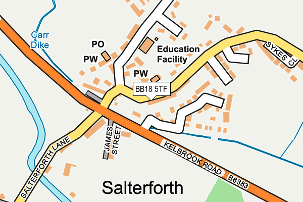
BB18 5TF lies on Kelbrook Road in Salterforth, Barnoldswick. BB18 5TF is located in the Earby & Coates electoral ward, within the local authority district of Pendle and the English Parliamentary constituency of Pendle. The Sub Integrated Care Board (ICB) Location is NHS Lancashire and South Cumbria ICB - 01A and the police force is Lancashire. This postcode has been in use since December 1997.


GetTheData
Source: OS OpenMap – Local (Ordnance Survey)
Source: OS VectorMap District (Ordnance Survey)
Licence: Open Government Licence (requires attribution)
| Easting | 388919 |
| Northing | 445431 |
| Latitude | 53.904933 |
| Longitude | -2.170147 |
GetTheData
Source: Open Postcode Geo
Licence: Open Government Licence
| Street | Kelbrook Road |
| Locality | Salterforth |
| Town/City | Barnoldswick |
| Country | England |
| Postcode District | BB18 |
➜ See where BB18 is on a map ➜ Where is Salterforth? | |
GetTheData
Source: Land Registry Price Paid Data
Licence: Open Government Licence
Elevation or altitude of BB18 5TF as distance above sea level:
| Metres | Feet | |
|---|---|---|
| Elevation | 150m | 492ft |
Elevation is measured from the approximate centre of the postcode, to the nearest point on an OS contour line from OS Terrain 50, which has contour spacing of ten vertical metres.
➜ How high above sea level am I? Find the elevation of your current position using your device's GPS.
GetTheData
Source: Open Postcode Elevation
Licence: Open Government Licence
| Ward | Earby & Coates |
| Constituency | Pendle |
GetTheData
Source: ONS Postcode Database
Licence: Open Government Licence
1, KELBROOK ROAD, SALTERFORTH, BARNOLDSWICK, BB18 5TF 2011 2 FEB £152,000 |
11, KELBROOK ROAD, SALTERFORTH, BARNOLDSWICK, BB18 5TF 2001 20 DEC £85,000 |
1, KELBROOK ROAD, SALTERFORTH, BARNOLDSWICK, BB18 5TF 2001 18 JAN £77,000 |
1, KELBROOK ROAD, SALTERFORTH, BARNOLDSWICK, BB18 5TF 2000 28 APR £45,000 |
GetTheData
Source: HM Land Registry Price Paid Data
Licence: Contains HM Land Registry data © Crown copyright and database right 2025. This data is licensed under the Open Government Licence v3.0.
| Post Office (Earby Road) | Salterforth | 22m |
| Silentnight (Kelbrook Road) | Salterforth | 45m |
| Kelbrook Road | Salterforth | 65m |
| Primary School (Cross Lane) | Salterforth | 167m |
| Sandhills Close (Earby Road) | Salterforth | 239m |
GetTheData
Source: NaPTAN
Licence: Open Government Licence
| Percentage of properties with Next Generation Access | 100.0% |
| Percentage of properties with Superfast Broadband | 100.0% |
| Percentage of properties with Ultrafast Broadband | 0.0% |
| Percentage of properties with Full Fibre Broadband | 0.0% |
Superfast Broadband is between 30Mbps and 300Mbps
Ultrafast Broadband is > 300Mbps
| Percentage of properties unable to receive 2Mbps | 0.0% |
| Percentage of properties unable to receive 5Mbps | 0.0% |
| Percentage of properties unable to receive 10Mbps | 0.0% |
| Percentage of properties unable to receive 30Mbps | 0.0% |
GetTheData
Source: Ofcom
Licence: Ofcom Terms of Use (requires attribution)
GetTheData
Source: ONS Postcode Database
Licence: Open Government Licence


➜ Get more ratings from the Food Standards Agency
GetTheData
Source: Food Standards Agency
Licence: FSA terms & conditions
| Last Collection | |||
|---|---|---|---|
| Location | Mon-Fri | Sat | Distance |
| Salterforth Post Office | 17:30 | 11:15 | 113m |
| Barnoldswick Post Office | 18:30 | 12:00 | 1,630m |
| Ghyll Meadows | 17:30 | 11:30 | 2,349m |
GetTheData
Source: Dracos
Licence: Creative Commons Attribution-ShareAlike
The below table lists the International Territorial Level (ITL) codes (formerly Nomenclature of Territorial Units for Statistics (NUTS) codes) and Local Administrative Units (LAU) codes for BB18 5TF:
| ITL 1 Code | Name |
|---|---|
| TLD | North West (England) |
| ITL 2 Code | Name |
| TLD4 | Lancashire |
| ITL 3 Code | Name |
| TLD46 | East Lancashire |
| LAU 1 Code | Name |
| E07000122 | Pendle |
GetTheData
Source: ONS Postcode Directory
Licence: Open Government Licence
The below table lists the Census Output Area (OA), Lower Layer Super Output Area (LSOA), and Middle Layer Super Output Area (MSOA) for BB18 5TF:
| Code | Name | |
|---|---|---|
| OA | E00127903 | |
| LSOA | E01025199 | Pendle 003A |
| MSOA | E02005242 | Pendle 003 |
GetTheData
Source: ONS Postcode Directory
Licence: Open Government Licence
| BB18 5TE | Cragg Row | 48m |
| BB18 5TL | Mill Cottages | 50m |
| BB18 5TP | Harry Street | 59m |
| BB18 5TS | Park View Terrace | 66m |
| BB18 5TU | Chapel Hill | 69m |
| BB18 5TR | James Street | 92m |
| BB18 5TY | The Bridle Path | 94m |
| BB18 5TX | Cross Lane Cottages | 120m |
| BB18 5TT | Salterforth Lane | 138m |
| BB18 5TZ | School Terrace | 144m |
GetTheData
Source: Open Postcode Geo; Land Registry Price Paid Data
Licence: Open Government Licence