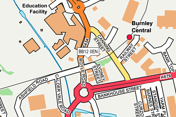
BB12 0EN is located in the Daneshouse with Stoneyholme electoral ward, within the local authority district of Burnley and the English Parliamentary constituency of Burnley. The Sub Integrated Care Board (ICB) Location is NHS Lancashire and South Cumbria ICB - 01A and the police force is Lancashire. This postcode has been in use since January 1980.


GetTheData
Source: OS OpenMap – Local (Ordnance Survey)
Source: OS VectorMap District (Ordnance Survey)
Licence: Open Government Licence (requires attribution)
| Easting | 383828 |
| Northing | 432990 |
| Latitude | 53.792967 |
| Longitude | -2.246972 |
GetTheData
Source: Open Postcode Geo
Licence: Open Government Licence
| Country | England |
| Postcode District | BB12 |
➜ See where BB12 is on a map ➜ Where is Burnley? | |
GetTheData
Source: Land Registry Price Paid Data
Licence: Open Government Licence
Elevation or altitude of BB12 0EN as distance above sea level:
| Metres | Feet | |
|---|---|---|
| Elevation | 110m | 361ft |
Elevation is measured from the approximate centre of the postcode, to the nearest point on an OS contour line from OS Terrain 50, which has contour spacing of ten vertical metres.
➜ How high above sea level am I? Find the elevation of your current position using your device's GPS.
GetTheData
Source: Open Postcode Elevation
Licence: Open Government Licence
| Ward | Daneshouse With Stoneyholme |
| Constituency | Burnley |
GetTheData
Source: ONS Postcode Database
Licence: Open Government Licence
| Central Railway Station (Canning Street) | Burnley | 81m |
| Burnley College (Rectory Road) | Stoneyholme | 207m |
| Asda (Princess Way) | Stoneyholme | 253m |
| Clifton Street (Westgate) | Burnley | 355m |
| Kent Street (Brougham Street) | Stoneyholme | 358m |
| Burnley Central Station | 0.1km |
| Burnley Barracks Station | 0.8km |
| Burnley Manchester Road Station | 0.9km |
GetTheData
Source: NaPTAN
Licence: Open Government Licence
GetTheData
Source: ONS Postcode Database
Licence: Open Government Licence


➜ Get more ratings from the Food Standards Agency
GetTheData
Source: Food Standards Agency
Licence: FSA terms & conditions
| Last Collection | |||
|---|---|---|---|
| Location | Mon-Fri | Sat | Distance |
| Bank Top | 17:30 | 11:00 | 269m |
| Burnley Delivery Office | 19:00 | 13:00 | 447m |
| Burnley Post Office | 18:30 | 11:00 | 477m |
GetTheData
Source: Dracos
Licence: Creative Commons Attribution-ShareAlike
The below table lists the International Territorial Level (ITL) codes (formerly Nomenclature of Territorial Units for Statistics (NUTS) codes) and Local Administrative Units (LAU) codes for BB12 0EN:
| ITL 1 Code | Name |
|---|---|
| TLD | North West (England) |
| ITL 2 Code | Name |
| TLD4 | Lancashire |
| ITL 3 Code | Name |
| TLD46 | East Lancashire |
| LAU 1 Code | Name |
| E07000117 | Burnley |
GetTheData
Source: ONS Postcode Directory
Licence: Open Government Licence
The below table lists the Census Output Area (OA), Lower Layer Super Output Area (LSOA), and Middle Layer Super Output Area (MSOA) for BB12 0EN:
| Code | Name | |
|---|---|---|
| OA | E00126261 | |
| LSOA | E01024877 | Burnley 003D |
| MSOA | E02005178 | Burnley 003 |
GetTheData
Source: ONS Postcode Directory
Licence: Open Government Licence
| BB12 0EL | Royle Road | 40m |
| BB11 1BS | Active Way | 75m |
| BB12 0AP | Belgrave Street | 302m |
| BB11 1AP | Standish Street | 302m |
| BB11 1PJ | Brown Street | 326m |
| BB12 0RA | Smith Street | 342m |
| BB12 0RB | Gill Street | 348m |
| BB11 1PD | St James's Street | 350m |
| BB11 1PP | St James's Street | 352m |
| BB12 0AJ | Burns Street | 360m |
GetTheData
Source: Open Postcode Geo; Land Registry Price Paid Data
Licence: Open Government Licence