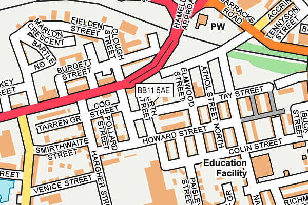
BB11 5AE lies on Accrington Road in Burnley. BB11 5AE is located in the Trinity electoral ward, within the local authority district of Burnley and the English Parliamentary constituency of Burnley. The Sub Integrated Care Board (ICB) Location is NHS Lancashire and South Cumbria ICB - 01A and the police force is Lancashire. This postcode has been in use since January 1980.


GetTheData
Source: OS OpenMap – Local (Ordnance Survey)
Source: OS VectorMap District (Ordnance Survey)
Licence: Open Government Licence (requires attribution)
| Easting | 382737 |
| Northing | 432342 |
| Latitude | 53.787108 |
| Longitude | -2.263496 |
GetTheData
Source: Open Postcode Geo
Licence: Open Government Licence
| Street | Accrington Road |
| Town/City | Burnley |
| Country | England |
| Postcode District | BB11 |
➜ See where BB11 is on a map ➜ Where is Burnley? | |
GetTheData
Source: Land Registry Price Paid Data
Licence: Open Government Licence
Elevation or altitude of BB11 5AE as distance above sea level:
| Metres | Feet | |
|---|---|---|
| Elevation | 150m | 492ft |
Elevation is measured from the approximate centre of the postcode, to the nearest point on an OS contour line from OS Terrain 50, which has contour spacing of ten vertical metres.
➜ How high above sea level am I? Find the elevation of your current position using your device's GPS.
GetTheData
Source: Open Postcode Elevation
Licence: Open Government Licence
| Ward | Trinity |
| Constituency | Burnley |
GetTheData
Source: ONS Postcode Database
Licence: Open Government Licence
| Hameldon Approach (Accrington Road) | Accrington Road | 69m |
| Hargher Street (Accrington Road) | Accrington Road | 90m |
| Hargher Street (Accrington Road) | Accrington Road | 96m |
| Coal Clough Bridge (Coal Clough Lane) | Burnham Gate | 306m |
| Cog Lane (Accrington Road) | Accrington Road | 308m |
| Burnley Barracks Station | 0.6km |
| Burnley Manchester Road Station | 1km |
| Rose Grove Station | 1.3km |
GetTheData
Source: NaPTAN
Licence: Open Government Licence
GetTheData
Source: ONS Postcode Database
Licence: Open Government Licence


➜ Get more ratings from the Food Standards Agency
GetTheData
Source: Food Standards Agency
Licence: FSA terms & conditions
| Last Collection | |||
|---|---|---|---|
| Location | Mon-Fri | Sat | Distance |
| Farrington Road | 18:00 | 11:00 | 1,208m |
| Burnley Delivery Office | 19:00 | 13:00 | 1,231m |
| Burnley Post Office | 18:30 | 11:00 | 1,235m |
GetTheData
Source: Dracos
Licence: Creative Commons Attribution-ShareAlike
The below table lists the International Territorial Level (ITL) codes (formerly Nomenclature of Territorial Units for Statistics (NUTS) codes) and Local Administrative Units (LAU) codes for BB11 5AE:
| ITL 1 Code | Name |
|---|---|
| TLD | North West (England) |
| ITL 2 Code | Name |
| TLD4 | Lancashire |
| ITL 3 Code | Name |
| TLD46 | East Lancashire |
| LAU 1 Code | Name |
| E07000117 | Burnley |
GetTheData
Source: ONS Postcode Directory
Licence: Open Government Licence
The below table lists the Census Output Area (OA), Lower Layer Super Output Area (LSOA), and Middle Layer Super Output Area (MSOA) for BB11 5AE:
| Code | Name | |
|---|---|---|
| OA | E00171906 | |
| LSOA | E01024908 | Burnley 010E |
| MSOA | E02005185 | Burnley 010 |
GetTheData
Source: ONS Postcode Directory
Licence: Open Government Licence
| BB11 4BU | Tay Street | 57m |
| BB11 5AJ | Accrington Road | 61m |
| BB11 4BJ | Howard Street | 66m |
| BB11 4BL | Bruce Street | 100m |
| BB11 5AG | Burdett Street | 107m |
| BB11 4BW | Arran Street | 107m |
| BB11 4BP | Elmwood Street | 112m |
| BB11 5AF | Peace Street | 121m |
| BB11 4EG | Hargher Street | 130m |
| BB11 4BS | Athol Street North | 143m |
GetTheData
Source: Open Postcode Geo; Land Registry Price Paid Data
Licence: Open Government Licence