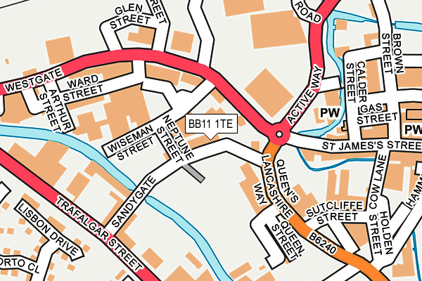
BB11 1TE is located in the Trinity electoral ward, within the local authority district of Burnley and the English Parliamentary constituency of Burnley. The Sub Integrated Care Board (ICB) Location is NHS Lancashire and South Cumbria ICB - 01A and the police force is Lancashire. This postcode has been in use since January 1980.


GetTheData
Source: OS OpenMap – Local (Ordnance Survey)
Source: OS VectorMap District (Ordnance Survey)
Licence: Open Government Licence (requires attribution)
| Easting | 383610 |
| Northing | 432634 |
| Latitude | 53.789761 |
| Longitude | -2.250262 |
GetTheData
Source: Open Postcode Geo
Licence: Open Government Licence
| Country | England |
| Postcode District | BB11 |
➜ See where BB11 is on a map ➜ Where is Burnley? | |
GetTheData
Source: Land Registry Price Paid Data
Licence: Open Government Licence
Elevation or altitude of BB11 1TE as distance above sea level:
| Metres | Feet | |
|---|---|---|
| Elevation | 120m | 394ft |
Elevation is measured from the approximate centre of the postcode, to the nearest point on an OS contour line from OS Terrain 50, which has contour spacing of ten vertical metres.
➜ How high above sea level am I? Find the elevation of your current position using your device's GPS.
GetTheData
Source: Open Postcode Elevation
Licence: Open Government Licence
| Ward | Trinity |
| Constituency | Burnley |
GetTheData
Source: ONS Postcode Database
Licence: Open Government Licence
| Clifton Street (Westgate) | Burnley | 128m |
| Clifton Street (Westgate) | Burnley | 150m |
| St James Street | Burnley | 275m |
| St James Street | Burnley | 292m |
| St James Street | Burnley | 293m |
| Burnley Barracks Station | 0.5km |
| Burnley Manchester Road Station | 0.5km |
| Burnley Central Station | 0.5km |
GetTheData
Source: NaPTAN
Licence: Open Government Licence
GetTheData
Source: ONS Postcode Database
Licence: Open Government Licence


➜ Get more ratings from the Food Standards Agency
GetTheData
Source: Food Standards Agency
Licence: FSA terms & conditions
| Last Collection | |||
|---|---|---|---|
| Location | Mon-Fri | Sat | Distance |
| Burnley Delivery Office | 19:00 | 13:00 | 347m |
| Burnley Post Office | 18:30 | 11:00 | 362m |
| Burnley Post Office | 18:30 | 11:00 | 364m |
GetTheData
Source: Dracos
Licence: Creative Commons Attribution-ShareAlike
The below table lists the International Territorial Level (ITL) codes (formerly Nomenclature of Territorial Units for Statistics (NUTS) codes) and Local Administrative Units (LAU) codes for BB11 1TE:
| ITL 1 Code | Name |
|---|---|
| TLD | North West (England) |
| ITL 2 Code | Name |
| TLD4 | Lancashire |
| ITL 3 Code | Name |
| TLD46 | East Lancashire |
| LAU 1 Code | Name |
| E07000117 | Burnley |
GetTheData
Source: ONS Postcode Directory
Licence: Open Government Licence
The below table lists the Census Output Area (OA), Lower Layer Super Output Area (LSOA), and Middle Layer Super Output Area (MSOA) for BB11 1TE:
| Code | Name | |
|---|---|---|
| OA | E00126429 | |
| LSOA | E01024909 | Burnley 010F |
| MSOA | E02005185 | Burnley 010 |
GetTheData
Source: ONS Postcode Directory
Licence: Open Government Licence
| BB11 1RW | Sandygate | 29m |
| BB11 1RU | Wiseman Street | 53m |
| BB11 1RT | Westgate | 58m |
| BB11 1BU | Slater Terrace | 145m |
| BB11 1HA | Queens Lancashire Way | 150m |
| BB11 1RY | Westgate | 154m |
| BB11 1RN | Sandygate | 166m |
| BB11 1NR | St James's Street | 181m |
| BB11 1PD | St James's Street | 196m |
| BB11 1SB | Arthur Street | 199m |
GetTheData
Source: Open Postcode Geo; Land Registry Price Paid Data
Licence: Open Government Licence