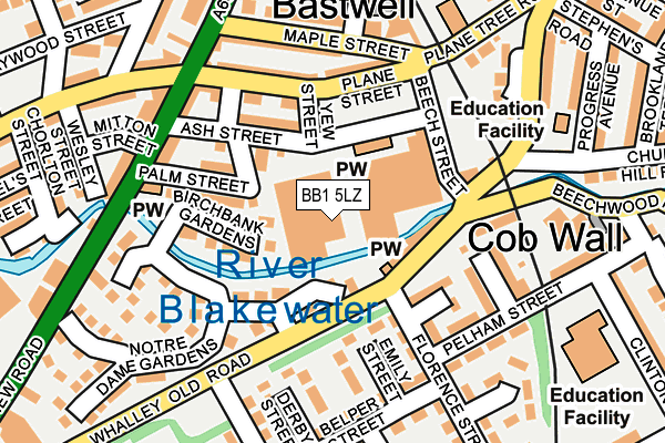
BB1 5LZ is located in the Bastwell & Daisyfield electoral ward, within the unitary authority of Blackburn with Darwen and the English Parliamentary constituency of Blackburn. The Sub Integrated Care Board (ICB) Location is NHS Lancashire and South Cumbria ICB - 00Q and the police force is Lancashire. This postcode has been in use since January 1983.


GetTheData
Source: OS OpenMap – Local (Ordnance Survey)
Source: OS VectorMap District (Ordnance Survey)
Licence: Open Government Licence (requires attribution)
| Easting | 369143 |
| Northing | 429032 |
| Latitude | 53.756727 |
| Longitude | -2.469486 |
GetTheData
Source: Open Postcode Geo
Licence: Open Government Licence
| Country | England |
| Postcode District | BB1 |
➜ See where BB1 is on a map ➜ Where is Blackburn? | |
GetTheData
Source: Land Registry Price Paid Data
Licence: Open Government Licence
Elevation or altitude of BB1 5LZ as distance above sea level:
| Metres | Feet | |
|---|---|---|
| Elevation | 120m | 394ft |
Elevation is measured from the approximate centre of the postcode, to the nearest point on an OS contour line from OS Terrain 50, which has contour spacing of ten vertical metres.
➜ How high above sea level am I? Find the elevation of your current position using your device's GPS.
GetTheData
Source: Open Postcode Elevation
Licence: Open Government Licence
| Ward | Bastwell & Daisyfield |
| Constituency | Blackburn |
GetTheData
Source: ONS Postcode Database
Licence: Open Government Licence
| Notre Dame Gardens (Whalley Old Road) | Brookhouse | 95m |
| Notre Dame Gardens (Whalley Old Road) | Brookhouse | 126m |
| Mitton Street (Whalley New Road) | Bastwell | 171m |
| Beachwood Wmc (Beechwood Road) | Bastwell | 173m |
| Beachwood Wmc (Beechwood Road) | Bastwell | 181m |
| Blackburn Station | 1.3km |
| Ramsgreave & Wilpshire Station | 2.6km |
| Mill Hill (Lancs) Station | 3.2km |
GetTheData
Source: NaPTAN
Licence: Open Government Licence
GetTheData
Source: ONS Postcode Database
Licence: Open Government Licence

➜ Get more ratings from the Food Standards Agency
GetTheData
Source: Food Standards Agency
Licence: FSA terms & conditions
| Last Collection | |||
|---|---|---|---|
| Location | Mon-Fri | Sat | Distance |
| Furthergate Ind Estate | 18:00 | 00:01 | 672m |
| Furthergate Ind Estate | 18:00 | 13:00 | 674m |
| Shear Brow | 16:45 | 12:00 | 1,207m |
GetTheData
Source: Dracos
Licence: Creative Commons Attribution-ShareAlike
| Risk of BB1 5LZ flooding from rivers and sea | Low |
| ➜ BB1 5LZ flood map | |
GetTheData
Source: Open Flood Risk by Postcode
Licence: Open Government Licence
The below table lists the International Territorial Level (ITL) codes (formerly Nomenclature of Territorial Units for Statistics (NUTS) codes) and Local Administrative Units (LAU) codes for BB1 5LZ:
| ITL 1 Code | Name |
|---|---|
| TLD | North West (England) |
| ITL 2 Code | Name |
| TLD4 | Lancashire |
| ITL 3 Code | Name |
| TLD41 | Blackburn with Darwen |
| LAU 1 Code | Name |
| E06000008 | Blackburn with Darwen |
GetTheData
Source: ONS Postcode Directory
Licence: Open Government Licence
The below table lists the Census Output Area (OA), Lower Layer Super Output Area (LSOA), and Middle Layer Super Output Area (MSOA) for BB1 5LZ:
| Code | Name | |
|---|---|---|
| OA | E00063427 | |
| LSOA | E01012578 | Blackburn with Darwen 003C |
| MSOA | E02002617 | Blackburn with Darwen 003 |
GetTheData
Source: ONS Postcode Directory
Licence: Open Government Licence
| BB1 5JJ | Cobwall | 66m |
| BB1 6NB | Birchbank Gardens | 85m |
| BB1 6JR | Ebony Street | 90m |
| BB1 6LT | Beech Street | 108m |
| BB1 6JQ | Palm Street | 113m |
| BB1 5HX | Emily Street | 120m |
| BB1 6LR | Plane Street | 134m |
| BB1 5JL | Beechwood Road | 160m |
| BB1 6LP | Maple Street | 162m |
| BB1 6LD | Whalley New Road | 165m |
GetTheData
Source: Open Postcode Geo; Land Registry Price Paid Data
Licence: Open Government Licence