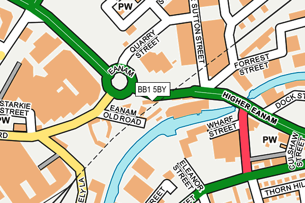
BB1 5BY lies on Eanam in Blackburn. BB1 5BY is located in the Blackburn Central electoral ward, within the unitary authority of Blackburn with Darwen and the English Parliamentary constituency of Blackburn. The Sub Integrated Care Board (ICB) Location is NHS Lancashire and South Cumbria ICB - 00Q and the police force is Lancashire. This postcode has been in use since January 1980.


GetTheData
Source: OS OpenMap – Local (Ordnance Survey)
Source: OS VectorMap District (Ordnance Survey)
Licence: Open Government Licence (requires attribution)
| Easting | 368828 |
| Northing | 428198 |
| Latitude | 53.749228 |
| Longitude | -2.474177 |
GetTheData
Source: Open Postcode Geo
Licence: Open Government Licence
| Street | Eanam |
| Town/City | Blackburn |
| Country | England |
| Postcode District | BB1 |
➜ See where BB1 is on a map ➜ Where is Blackburn? | |
GetTheData
Source: Land Registry Price Paid Data
Licence: Open Government Licence
Elevation or altitude of BB1 5BY as distance above sea level:
| Metres | Feet | |
|---|---|---|
| Elevation | 120m | 394ft |
Elevation is measured from the approximate centre of the postcode, to the nearest point on an OS contour line from OS Terrain 50, which has contour spacing of ten vertical metres.
➜ How high above sea level am I? Find the elevation of your current position using your device's GPS.
GetTheData
Source: Open Postcode Elevation
Licence: Open Government Licence
| Ward | Blackburn Central |
| Constituency | Blackburn |
GetTheData
Source: ONS Postcode Database
Licence: Open Government Licence
16, EANAM, BLACKBURN, BB1 5BY 2005 16 SEP £850,000 |
GetTheData
Source: HM Land Registry Price Paid Data
Licence: Contains HM Land Registry data © Crown copyright and database right 2025. This data is licensed under the Open Government Licence v3.0.
| Eanam Wharf (Eanam) | Blackburn | 79m |
| Eanem Old Road (Salford) | Blackburn | 162m |
| Chester Street (Higher Audley Street) | Audley | 202m |
| Higher Eanam | Audley | 262m |
| Thornhill Close (Chester Street) | Audley | 272m |
| Blackburn Station | 0.4km |
| Mill Hill (Lancs) Station | 2.4km |
| Ramsgreave & Wilpshire Station | 3.4km |
GetTheData
Source: NaPTAN
Licence: Open Government Licence
GetTheData
Source: ONS Postcode Database
Licence: Open Government Licence


➜ Get more ratings from the Food Standards Agency
GetTheData
Source: Food Standards Agency
Licence: FSA terms & conditions
| Last Collection | |||
|---|---|---|---|
| Location | Mon-Fri | Sat | Distance |
| Railway Station | 16:30 | 12:15 | 502m |
| Church Street | 16:30 | 13:00 | 503m |
| Blackburn Cathedral | 16:30 | 13:00 | 609m |
GetTheData
Source: Dracos
Licence: Creative Commons Attribution-ShareAlike
The below table lists the International Territorial Level (ITL) codes (formerly Nomenclature of Territorial Units for Statistics (NUTS) codes) and Local Administrative Units (LAU) codes for BB1 5BY:
| ITL 1 Code | Name |
|---|---|
| TLD | North West (England) |
| ITL 2 Code | Name |
| TLD4 | Lancashire |
| ITL 3 Code | Name |
| TLD41 | Blackburn with Darwen |
| LAU 1 Code | Name |
| E06000008 | Blackburn with Darwen |
GetTheData
Source: ONS Postcode Directory
Licence: Open Government Licence
The below table lists the Census Output Area (OA), Lower Layer Super Output Area (LSOA), and Middle Layer Super Output Area (MSOA) for BB1 5BY:
| Code | Name | |
|---|---|---|
| OA | E00063733 | |
| LSOA | E01012643 | Blackburn with Darwen 006C |
| MSOA | E02002620 | Blackburn with Darwen 006 |
GetTheData
Source: ONS Postcode Directory
Licence: Open Government Licence
| BB1 5BX | Eanam Wharf | 34m |
| BB1 5BL | Eanam Wharf | 57m |
| BB1 1JA | Higher Barn Street | 197m |
| BB1 5DT | Manner Sutton Street | 209m |
| BB1 1HQ | Cicely Lane | 213m |
| BB1 1DU | Dartford Close | 252m |
| BB1 3BB | Forrest Street | 259m |
| BB1 1DL | Oxford Close | 267m |
| BB1 3AZ | Higher Eanam | 276m |
| BB1 1DY | Cambridge Close | 281m |
GetTheData
Source: Open Postcode Geo; Land Registry Price Paid Data
Licence: Open Government Licence