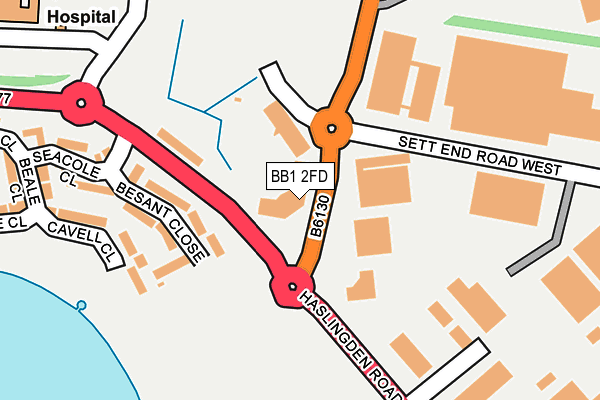
BB1 2FD is located in the Blackburn South East electoral ward, within the unitary authority of Blackburn with Darwen and the English Parliamentary constituency of Blackburn. The Sub Integrated Care Board (ICB) Location is NHS Lancashire and South Cumbria ICB - 00Q and the police force is Lancashire. This postcode has been in use since January 2008.


GetTheData
Source: OS OpenMap – Local (Ordnance Survey)
Source: OS VectorMap District (Ordnance Survey)
Licence: Open Government Licence (requires attribution)
| Easting | 370048 |
| Northing | 426470 |
| Latitude | 53.733769 |
| Longitude | -2.455509 |
GetTheData
Source: Open Postcode Geo
Licence: Open Government Licence
| Country | England |
| Postcode District | BB1 |
➜ See where BB1 is on a map ➜ Where is Blackburn? | |
GetTheData
Source: Land Registry Price Paid Data
Licence: Open Government Licence
Elevation or altitude of BB1 2FD as distance above sea level:
| Metres | Feet | |
|---|---|---|
| Elevation | 190m | 623ft |
Elevation is measured from the approximate centre of the postcode, to the nearest point on an OS contour line from OS Terrain 50, which has contour spacing of ten vertical metres.
➜ How high above sea level am I? Find the elevation of your current position using your device's GPS.
GetTheData
Source: Open Postcode Elevation
Licence: Open Government Licence
| Ward | Blackburn South East |
| Constituency | Blackburn |
GetTheData
Source: ONS Postcode Database
Licence: Open Government Licence
| Evolution Park (Shadsworth Road) | Shadsworth | 59m |
| Sett End Road West | Guide | 76m |
| Evolution Park (Shadsworth Road) | Shadsworth | 90m |
| Seacole Close (Haslingden Road) | Guide | 92m |
| Sett End Road (Shadsworth Road) | Shadsworth | 104m |
| Blackburn Station | 2.1km |
| Mill Hill (Lancs) Station | 3.1km |
| Darwen Station | 4km |
GetTheData
Source: NaPTAN
Licence: Open Government Licence
GetTheData
Source: ONS Postcode Database
Licence: Open Government Licence


➜ Get more ratings from the Food Standards Agency
GetTheData
Source: Food Standards Agency
Licence: FSA terms & conditions
| Last Collection | |||
|---|---|---|---|
| Location | Mon-Fri | Sat | Distance |
| Old Bank Lane | 16:15 | 11:00 | 891m |
| Longton Street | 17:15 | 13:15 | 1,466m |
| 188 Burnley Road | 16:30 | 11:30 | 2,098m |
GetTheData
Source: Dracos
Licence: Creative Commons Attribution-ShareAlike
The below table lists the International Territorial Level (ITL) codes (formerly Nomenclature of Territorial Units for Statistics (NUTS) codes) and Local Administrative Units (LAU) codes for BB1 2FD:
| ITL 1 Code | Name |
|---|---|
| TLD | North West (England) |
| ITL 2 Code | Name |
| TLD4 | Lancashire |
| ITL 3 Code | Name |
| TLD41 | Blackburn with Darwen |
| LAU 1 Code | Name |
| E06000008 | Blackburn with Darwen |
GetTheData
Source: ONS Postcode Directory
Licence: Open Government Licence
The below table lists the Census Output Area (OA), Lower Layer Super Output Area (LSOA), and Middle Layer Super Output Area (MSOA) for BB1 2FD:
| Code | Name | |
|---|---|---|
| OA | E00171893 | |
| LSOA | E01012632 | Blackburn with Darwen 011F |
| MSOA | E02002625 | Blackburn with Darwen 011 |
GetTheData
Source: ONS Postcode Directory
Licence: Open Government Licence
| BB1 2ND | Haslingden Road | 142m |
| BB1 2RG | Besant Close | 168m |
| BB1 2RF | Cavell Close | 207m |
| BB1 2RA | Seacole Close | 226m |
| BB1 2EH | Wilkinson Way | 260m |
| BB1 2RD | Beale Close | 294m |
| BB1 2RE | Nightingale Close | 342m |
| BB1 2RB | Pankhurst Close | 350m |
| BB1 2JT | Nuttalls Way | 419m |
| BB1 1XH | Martindale Close | 509m |
GetTheData
Source: Open Postcode Geo; Land Registry Price Paid Data
Licence: Open Government Licence