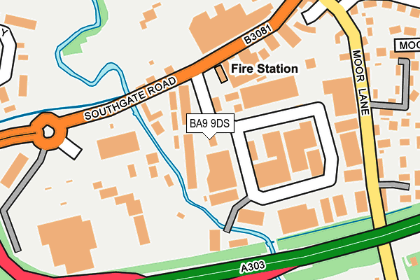
BA9 9DS is located in the Wincanton & Bruton electoral ward, within the unitary authority of Somerset and the English Parliamentary constituency of Somerton and Frome. The Sub Integrated Care Board (ICB) Location is NHS Somerset ICB - 11X and the police force is Avon and Somerset. This postcode has been in use since November 2003.


GetTheData
Source: OS OpenMap – Local (Ordnance Survey)
Source: OS VectorMap District (Ordnance Survey)
Licence: Open Government Licence (requires attribution)
| Easting | 371089 |
| Northing | 127990 |
| Latitude | 51.050523 |
| Longitude | -2.413829 |
GetTheData
Source: Open Postcode Geo
Licence: Open Government Licence
| Country | England |
| Postcode District | BA9 |
➜ See where BA9 is on a map ➜ Where is Wincanton? | |
GetTheData
Source: Land Registry Price Paid Data
Licence: Open Government Licence
Elevation or altitude of BA9 9DS as distance above sea level:
| Metres | Feet | |
|---|---|---|
| Elevation | 70m | 230ft |
Elevation is measured from the approximate centre of the postcode, to the nearest point on an OS contour line from OS Terrain 50, which has contour spacing of ten vertical metres.
➜ How high above sea level am I? Find the elevation of your current position using your device's GPS.
GetTheData
Source: Open Postcode Elevation
Licence: Open Government Licence
| Ward | Wincanton & Bruton |
| Constituency | Somerton And Frome |
GetTheData
Source: ONS Postcode Database
Licence: Open Government Licence
| Carmel Villas (Southgate Road) | Wincanton | 120m |
| Hawkers Bridge (Southgate Road) | Wincanton | 138m |
| Swc Depot (Southgate Road) | Wincanton | 156m |
| Swc Depot (Southgate Road) | Wincanton | 164m |
| County Primary School (South Street) | Wincanton | 352m |
GetTheData
Source: NaPTAN
Licence: Open Government Licence
GetTheData
Source: ONS Postcode Database
Licence: Open Government Licence


➜ Get more ratings from the Food Standards Agency
GetTheData
Source: Food Standards Agency
Licence: FSA terms & conditions
| Last Collection | |||
|---|---|---|---|
| Location | Mon-Fri | Sat | Distance |
| South Road | 17:30 | 11:30 | 278m |
| North Street | 17:30 | 11:30 | 827m |
| Shalford | 11:00 | 09:30 | 2,068m |
GetTheData
Source: Dracos
Licence: Creative Commons Attribution-ShareAlike
| Risk of BA9 9DS flooding from rivers and sea | Low |
| ➜ BA9 9DS flood map | |
GetTheData
Source: Open Flood Risk by Postcode
Licence: Open Government Licence
The below table lists the International Territorial Level (ITL) codes (formerly Nomenclature of Territorial Units for Statistics (NUTS) codes) and Local Administrative Units (LAU) codes for BA9 9DS:
| ITL 1 Code | Name |
|---|---|
| TLK | South West (England) |
| ITL 2 Code | Name |
| TLK2 | Dorset and Somerset |
| ITL 3 Code | Name |
| TLK23 | Somerset CC |
| LAU 1 Code | Name |
| E07000189 | South Somerset |
GetTheData
Source: ONS Postcode Directory
Licence: Open Government Licence
The below table lists the Census Output Area (OA), Lower Layer Super Output Area (LSOA), and Middle Layer Super Output Area (MSOA) for BA9 9DS:
| Code | Name | |
|---|---|---|
| OA | E00148882 | |
| LSOA | E01029228 | South Somerset 005C |
| MSOA | E02006079 | South Somerset 005 |
GetTheData
Source: ONS Postcode Directory
Licence: Open Government Licence
| BA9 9DT | Bennetts Field Trading Estate | 91m |
| BA9 9EB | Southgate Road | 96m |
| BA9 9EF | Carmel Villas | 122m |
| BA9 9EH | Fire House Mews | 235m |
| BA9 9RJ | Fairfield Court | 244m |
| BA9 9EJ | Moor Lane | 245m |
| BA9 9DP | Crofts Mead | 275m |
| BA9 9SQ | Maple Close | 297m |
| BA9 9EL | Priory Villas | 301m |
| BA9 9SJ | Pines Close | 311m |
GetTheData
Source: Open Postcode Geo; Land Registry Price Paid Data
Licence: Open Government Licence