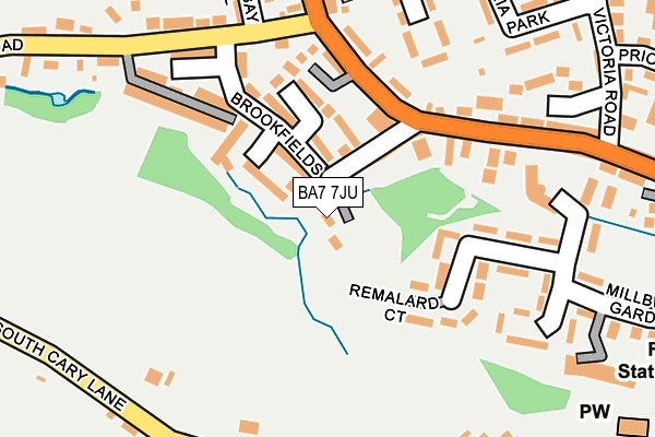
BA7 7JU lies on Mill Lane in Castle Cary. BA7 7JU is located in the Castle Cary electoral ward, within the unitary authority of Somerset and the English Parliamentary constituency of Somerton and Frome. The Sub Integrated Care Board (ICB) Location is NHS Somerset ICB - 11X and the police force is Avon and Somerset. This postcode has been in use since June 1981.


GetTheData
Source: OS OpenMap – Local (Ordnance Survey)
Source: OS VectorMap District (Ordnance Survey)
Licence: Open Government Licence (requires attribution)
| Easting | 363644 |
| Northing | 132246 |
| Latitude | 51.088367 |
| Longitude | -2.520466 |
GetTheData
Source: Open Postcode Geo
Licence: Open Government Licence
| Street | Mill Lane |
| Town/City | Castle Cary |
| Country | England |
| Postcode District | BA7 |
➜ See where BA7 is on a map ➜ Where is Castle Cary? | |
GetTheData
Source: Land Registry Price Paid Data
Licence: Open Government Licence
Elevation or altitude of BA7 7JU as distance above sea level:
| Metres | Feet | |
|---|---|---|
| Elevation | 70m | 230ft |
Elevation is measured from the approximate centre of the postcode, to the nearest point on an OS contour line from OS Terrain 50, which has contour spacing of ten vertical metres.
➜ How high above sea level am I? Find the elevation of your current position using your device's GPS.
GetTheData
Source: Open Postcode Elevation
Licence: Open Government Licence
| Ward | Castle Cary |
| Constituency | Somerton And Frome |
GetTheData
Source: ONS Postcode Database
Licence: Open Government Licence
GRANTLANDS, MILL LANE, CASTLE CARY, BA7 7JU 2022 14 JAN £470,000 |
CEBEES, MILL LANE, CASTLE CARY, BA7 7JU 2015 4 FEB £280,000 |
MILL BARN, MILL LANE, CASTLE CARY, BA7 7JU 2002 25 NOV £250,000 |
CEBEES, MILL LANE, CASTLE CARY, BA7 7JU 1995 28 JUL £40,000 |
GetTheData
Source: HM Land Registry Price Paid Data
Licence: Contains HM Land Registry data © Crown copyright and database right 2025. This data is licensed under the Open Government Licence v3.0.
| Station Road | Castle Cary | 297m |
| Victoria Gardens | Ansford | 298m |
| Victoria Gardens | Ansford | 299m |
| Station Road | Castle Cary | 342m |
| Horse Pond Inn (Park Street) | Castle Cary | 366m |
| Castle Cary Station | 1.3km |
GetTheData
Source: NaPTAN
Licence: Open Government Licence
| Percentage of properties with Next Generation Access | 100.0% |
| Percentage of properties with Superfast Broadband | 100.0% |
| Percentage of properties with Ultrafast Broadband | 0.0% |
| Percentage of properties with Full Fibre Broadband | 0.0% |
Superfast Broadband is between 30Mbps and 300Mbps
Ultrafast Broadband is > 300Mbps
| Percentage of properties unable to receive 2Mbps | 0.0% |
| Percentage of properties unable to receive 5Mbps | 0.0% |
| Percentage of properties unable to receive 10Mbps | 0.0% |
| Percentage of properties unable to receive 30Mbps | 0.0% |
GetTheData
Source: Ofcom
Licence: Ofcom Terms of Use (requires attribution)
GetTheData
Source: ONS Postcode Database
Licence: Open Government Licence


➜ Get more ratings from the Food Standards Agency
GetTheData
Source: Food Standards Agency
Licence: FSA terms & conditions
| Last Collection | |||
|---|---|---|---|
| Location | Mon-Fri | Sat | Distance |
| Torbay Road | 11:10 | 09:30 | 249m |
| Cumnock Crescent | 11:00 | 11:00 | 855m |
| Clanville | 11:00 | 07:30 | 1,373m |
GetTheData
Source: Dracos
Licence: Creative Commons Attribution-ShareAlike
The below table lists the International Territorial Level (ITL) codes (formerly Nomenclature of Territorial Units for Statistics (NUTS) codes) and Local Administrative Units (LAU) codes for BA7 7JU:
| ITL 1 Code | Name |
|---|---|
| TLK | South West (England) |
| ITL 2 Code | Name |
| TLK2 | Dorset and Somerset |
| ITL 3 Code | Name |
| TLK23 | Somerset CC |
| LAU 1 Code | Name |
| E07000189 | South Somerset |
GetTheData
Source: ONS Postcode Directory
Licence: Open Government Licence
The below table lists the Census Output Area (OA), Lower Layer Super Output Area (LSOA), and Middle Layer Super Output Area (MSOA) for BA7 7JU:
| Code | Name | |
|---|---|---|
| OA | E00148574 | |
| LSOA | E01029167 | South Somerset 002B |
| MSOA | E02006076 | South Somerset 002 |
GetTheData
Source: ONS Postcode Directory
Licence: Open Government Licence
| BA7 7BF | Badgers Folly | 67m |
| BA7 7DU | Bridgwater Buildings | 79m |
| BA7 7BS | Brookfields | 114m |
| BA7 7BY | Station Road | 138m |
| BA7 7HS | Donnes Terrace | 143m |
| BA7 7EF | Millbrook Gardens | 166m |
| BA7 7BZ | Salisbury Terrace | 167m |
| BA7 7BX | Station Road | 179m |
| BA7 7DA | Moore Villas | 211m |
| BA7 7DW | Torbay Road | 213m |
GetTheData
Source: Open Postcode Geo; Land Registry Price Paid Data
Licence: Open Government Licence