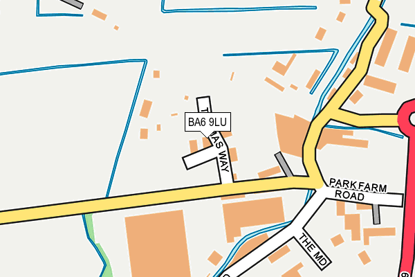
BA6 9LU is located in the Glastonbury electoral ward, within the unitary authority of Somerset and the English Parliamentary constituency of Wells. The Sub Integrated Care Board (ICB) Location is NHS Somerset ICB - 11X and the police force is Avon and Somerset. This postcode has been in use since February 1990.


GetTheData
Source: OS OpenMap – Local (Ordnance Survey)
Source: OS VectorMap District (Ordnance Survey)
Licence: Open Government Licence (requires attribution)
| Easting | 348972 |
| Northing | 138918 |
| Latitude | 51.147231 |
| Longitude | -2.730887 |
GetTheData
Source: Open Postcode Geo
Licence: Open Government Licence
| Country | England |
| Postcode District | BA6 |
➜ See where BA6 is on a map ➜ Where is Glastonbury? | |
GetTheData
Source: Land Registry Price Paid Data
Licence: Open Government Licence
Elevation or altitude of BA6 9LU as distance above sea level:
| Metres | Feet | |
|---|---|---|
| Elevation | 10m | 33ft |
Elevation is measured from the approximate centre of the postcode, to the nearest point on an OS contour line from OS Terrain 50, which has contour spacing of ten vertical metres.
➜ How high above sea level am I? Find the elevation of your current position using your device's GPS.
GetTheData
Source: Open Postcode Elevation
Licence: Open Government Licence
| Ward | Glastonbury |
| Constituency | Wells |
GetTheData
Source: ONS Postcode Database
Licence: Open Government Licence
| Wirral Park Roundabout (Street Road) | Glastonbury | 625m |
| Wirral Park Roundabout (Street Road) | Glastonbury | 631m |
| Drill Hall (Street Road) | Glastonbury | 693m |
| Drill Hall (Street Road) | Glastonbury | 702m |
| Touring Caravan Park (Godney Road) | Glastonbury | 825m |
GetTheData
Source: NaPTAN
Licence: Open Government Licence
GetTheData
Source: ONS Postcode Database
Licence: Open Government Licence


➜ Get more ratings from the Food Standards Agency
GetTheData
Source: Food Standards Agency
Licence: FSA terms & conditions
| Last Collection | |||
|---|---|---|---|
| Location | Mon-Fri | Sat | Distance |
| Benedict Street | 17:30 | 12:15 | 752m |
| Glastonbury Post Office | 18:00 | 12:45 | 1,128m |
| The Cross | 16:00 | 11:30 | 1,925m |
GetTheData
Source: Dracos
Licence: Creative Commons Attribution-ShareAlike
| Risk of BA6 9LU flooding from rivers and sea | Medium |
| ➜ BA6 9LU flood map | |
GetTheData
Source: Open Flood Risk by Postcode
Licence: Open Government Licence
The below table lists the International Territorial Level (ITL) codes (formerly Nomenclature of Territorial Units for Statistics (NUTS) codes) and Local Administrative Units (LAU) codes for BA6 9LU:
| ITL 1 Code | Name |
|---|---|
| TLK | South West (England) |
| ITL 2 Code | Name |
| TLK2 | Dorset and Somerset |
| ITL 3 Code | Name |
| TLK23 | Somerset CC |
| LAU 1 Code | Name |
| E07000187 | Mendip |
GetTheData
Source: ONS Postcode Directory
Licence: Open Government Licence
The below table lists the Census Output Area (OA), Lower Layer Super Output Area (LSOA), and Middle Layer Super Output Area (MSOA) for BA6 9LU:
| Code | Name | |
|---|---|---|
| OA | E00147919 | |
| LSOA | E01029047 | Mendip 012A |
| MSOA | E02006058 | Mendip 012 |
GetTheData
Source: ONS Postcode Directory
Licence: Open Government Licence
| BA6 9LZ | Dyehouse Lane | 244m |
| BA6 9EZ | Benedict Street | 415m |
| BA6 9AE | Carmine Close | 428m |
| BA6 9NT | Beckery | 436m |
| BA6 9FR | Wirral Park Road | 436m |
| BA6 9NQ | Benedict Street | 443m |
| BA6 9PR | Stag Way | 448m |
| BA6 9QB | Drum Avenue | 486m |
| BA6 9PZ | Pike Close | 488m |
| BA6 9PN | Fawn Close | 515m |
GetTheData
Source: Open Postcode Geo; Land Registry Price Paid Data
Licence: Open Government Licence