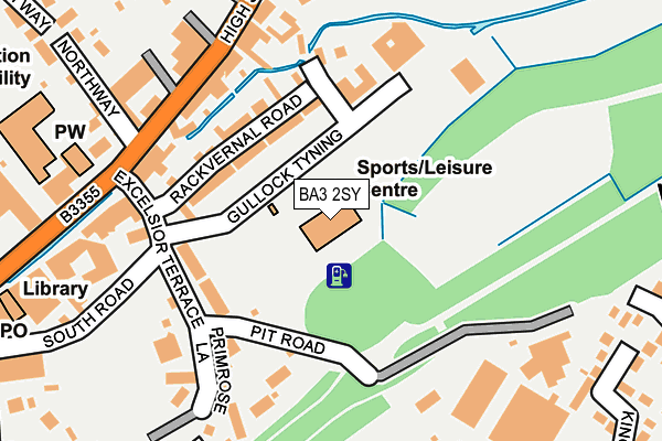
BA3 2SY is located in the Midsomer Norton Redfield electoral ward, within the unitary authority of Bath and North East Somerset and the English Parliamentary constituency of North East Somerset. The Sub Integrated Care Board (ICB) Location is NHS Bath and North East Somerset, Swindon and Wiltshire ICB - 92 and the police force is Avon and Somerset. This postcode has been in use since July 2015.


GetTheData
Source: OS OpenMap – Local (Ordnance Survey)
Source: OS VectorMap District (Ordnance Survey)
Licence: Open Government Licence (requires attribution)
| Easting | 366785 |
| Northing | 154244 |
| Latitude | 51.286352 |
| Longitude | -2.477663 |
GetTheData
Source: Open Postcode Geo
Licence: Open Government Licence
| Country | England |
| Postcode District | BA3 |
➜ See where BA3 is on a map ➜ Where is Midsomer Norton? | |
GetTheData
Source: Land Registry Price Paid Data
Licence: Open Government Licence
Elevation or altitude of BA3 2SY as distance above sea level:
| Metres | Feet | |
|---|---|---|
| Elevation | 90m | 295ft |
Elevation is measured from the approximate centre of the postcode, to the nearest point on an OS contour line from OS Terrain 50, which has contour spacing of ten vertical metres.
➜ How high above sea level am I? Find the elevation of your current position using your device's GPS.
GetTheData
Source: Open Postcode Elevation
Licence: Open Government Licence
| Ward | Midsomer Norton Redfield |
| Constituency | North East Somerset |
GetTheData
Source: ONS Postcode Database
Licence: Open Government Licence
| High St Top (High Street) | Midsomer Norton | 292m |
| Library (High Street) | Midsomer Norton | 305m |
| Elm View (North Road) | Midsomer Norton | 364m |
| Town Hall (High Street) | Midsomer Norton | 373m |
| Longfellow Road (Wesley Avenue) | Westfield | 391m |
GetTheData
Source: NaPTAN
Licence: Open Government Licence
GetTheData
Source: ONS Postcode Database
Licence: Open Government Licence


➜ Get more ratings from the Food Standards Agency
GetTheData
Source: Food Standards Agency
Licence: FSA terms & conditions
| Last Collection | |||
|---|---|---|---|
| Location | Mon-Fri | Sat | Distance |
| Clevedon Road | 17:00 | 11:30 | 468m |
| Midsomer Norton P.o. | 17:30 | 12:00 | 612m |
| Radstock Post Office Radco | 17:30 | 12:00 | 2,166m |
GetTheData
Source: Dracos
Licence: Creative Commons Attribution-ShareAlike
The below table lists the International Territorial Level (ITL) codes (formerly Nomenclature of Territorial Units for Statistics (NUTS) codes) and Local Administrative Units (LAU) codes for BA3 2SY:
| ITL 1 Code | Name |
|---|---|
| TLK | South West (England) |
| ITL 2 Code | Name |
| TLK1 | Gloucestershire, Wiltshire and Bath/Bristol area |
| ITL 3 Code | Name |
| TLK12 | Bath and North East Somerset, North Somerset and South Gloucestershire |
| LAU 1 Code | Name |
| E06000022 | Bath and North East Somerset |
GetTheData
Source: ONS Postcode Directory
Licence: Open Government Licence
The below table lists the Census Output Area (OA), Lower Layer Super Output Area (LSOA), and Middle Layer Super Output Area (MSOA) for BA3 2SY:
| Code | Name | |
|---|---|---|
| OA | E00072852 | |
| LSOA | E01014423 | Bath and North East Somerset 025D |
| MSOA | E02003009 | Bath and North East Somerset 025 |
GetTheData
Source: ONS Postcode Directory
Licence: Open Government Licence
| BA3 2UG | Rackvernal Road | 94m |
| BA3 2SU | Gullock Tyning | 123m |
| BA3 2UW | Excelsior Terrace | 129m |
| BA3 2US | Primrose Terrace | 144m |
| BA3 2UQ | Ham Gardens | 152m |
| BA3 2DE | High Street | 164m |
| BA3 2DW | High Street | 197m |
| BA3 2UP | Primrose Lane | 203m |
| BA3 2DH | Rackvernal Court | 207m |
| BA3 2AY | Hope Terrace | 242m |
GetTheData
Source: Open Postcode Geo; Land Registry Price Paid Data
Licence: Open Government Licence