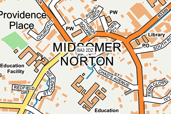
BA3 2DZ lies on The Island in Midsomer Norton, Radstock. BA3 2DZ is located in the Midsomer Norton Redfield electoral ward, within the unitary authority of Bath and North East Somerset and the English Parliamentary constituency of North East Somerset. The Sub Integrated Care Board (ICB) Location is NHS Bath and North East Somerset, Swindon and Wiltshire ICB - 92 and the police force is Avon and Somerset. This postcode has been in use since June 1999.


GetTheData
Source: OS OpenMap – Local (Ordnance Survey)
Source: OS VectorMap District (Ordnance Survey)
Licence: Open Government Licence (requires attribution)
| Easting | 366286 |
| Northing | 154104 |
| Latitude | 51.285068 |
| Longitude | -2.484804 |
GetTheData
Source: Open Postcode Geo
Licence: Open Government Licence
| Street | The Island |
| Locality | Midsomer Norton |
| Town/City | Radstock |
| Country | England |
| Postcode District | BA3 |
➜ See where BA3 is on a map ➜ Where is Midsomer Norton? | |
GetTheData
Source: Land Registry Price Paid Data
Licence: Open Government Licence
Elevation or altitude of BA3 2DZ as distance above sea level:
| Metres | Feet | |
|---|---|---|
| Elevation | 90m | 295ft |
Elevation is measured from the approximate centre of the postcode, to the nearest point on an OS contour line from OS Terrain 50, which has contour spacing of ten vertical metres.
➜ How high above sea level am I? Find the elevation of your current position using your device's GPS.
GetTheData
Source: Open Postcode Elevation
Licence: Open Government Licence
| Ward | Midsomer Norton Redfield |
| Constituency | North East Somerset |
GetTheData
Source: ONS Postcode Database
Licence: Open Government Licence
THE ISLAND HOUSE, THE ISLAND, MIDSOMER NORTON, RADSTOCK, BA3 2DZ 2023 1 MAR £368,000 |
THE ISLAND HOUSE, THE ISLAND, MIDSOMER NORTON, RADSTOCK, BA3 2DZ 2010 30 JUN £320,000 |
➜ Midsomer Norton house prices
GetTheData
Source: HM Land Registry Price Paid Data
Licence: Contains HM Land Registry data © Crown copyright and database right 2025. This data is licensed under the Open Government Licence v3.0.
| Somervale School | Midsomer Norton | 83m |
| Somervale School (Redfield Road) | Midsomer Norton | 85m |
| Town Hall (High Street) | Midsomer Norton | 128m |
| Town Hall (High Street) | Midsomer Norton | 150m |
| Library (High Street) | Midsomer Norton | 217m |
GetTheData
Source: NaPTAN
Licence: Open Government Licence
GetTheData
Source: ONS Postcode Database
Licence: Open Government Licence


➜ Get more ratings from the Food Standards Agency
GetTheData
Source: Food Standards Agency
Licence: FSA terms & conditions
| Last Collection | |||
|---|---|---|---|
| Location | Mon-Fri | Sat | Distance |
| Clevedon Road | 17:00 | 11:30 | 407m |
| Midsomer Norton P.o. | 17:30 | 12:00 | 1,079m |
| Radstock Post Office Radco | 17:30 | 12:00 | 2,684m |
GetTheData
Source: Dracos
Licence: Creative Commons Attribution-ShareAlike
The below table lists the International Territorial Level (ITL) codes (formerly Nomenclature of Territorial Units for Statistics (NUTS) codes) and Local Administrative Units (LAU) codes for BA3 2DZ:
| ITL 1 Code | Name |
|---|---|
| TLK | South West (England) |
| ITL 2 Code | Name |
| TLK1 | Gloucestershire, Wiltshire and Bath/Bristol area |
| ITL 3 Code | Name |
| TLK12 | Bath and North East Somerset, North Somerset and South Gloucestershire |
| LAU 1 Code | Name |
| E06000022 | Bath and North East Somerset |
GetTheData
Source: ONS Postcode Directory
Licence: Open Government Licence
The below table lists the Census Output Area (OA), Lower Layer Super Output Area (LSOA), and Middle Layer Super Output Area (MSOA) for BA3 2DZ:
| Code | Name | |
|---|---|---|
| OA | E00072868 | |
| LSOA | E01014425 | Bath and North East Somerset 027B |
| MSOA | E02003011 | Bath and North East Somerset 027 |
GetTheData
Source: ONS Postcode Directory
Licence: Open Government Licence
| BA3 2HA | The Island | 54m |
| BA3 2HF | The Island | 89m |
| BA3 2HN | High Street | 96m |
| BA3 2HQ | The Island | 97m |
| BA3 2HX | Church Square | 110m |
| BA3 2HG | St Chads Avenue | 129m |
| BA3 2LE | High Street | 139m |
| BA3 2JL | Church Lane | 142m |
| BA3 2EU | Silver Street | 155m |
| BA3 2HY | Pows Orchard | 164m |
GetTheData
Source: Open Postcode Geo; Land Registry Price Paid Data
Licence: Open Government Licence