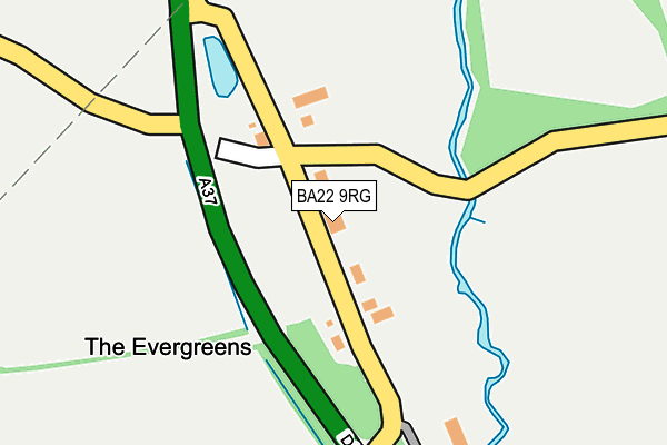
BA22 9RG is located in the Coker electoral ward, within the unitary authority of Somerset and the English Parliamentary constituency of Yeovil. The Sub Integrated Care Board (ICB) Location is NHS Somerset ICB - 11X and the police force is Avon and Somerset. This postcode has been in use since January 1980.


GetTheData
Source: OS OpenMap – Local (Ordnance Survey)
Source: OS VectorMap District (Ordnance Survey)
Licence: Open Government Licence (requires attribution)
| Easting | 356688 |
| Northing | 110915 |
| Latitude | 50.896073 |
| Longitude | -2.617229 |
GetTheData
Source: Open Postcode Geo
Licence: Open Government Licence
| Country | England |
| Postcode District | BA22 |
➜ See where BA22 is on a map | |
GetTheData
Source: Land Registry Price Paid Data
Licence: Open Government Licence
Elevation or altitude of BA22 9RG as distance above sea level:
| Metres | Feet | |
|---|---|---|
| Elevation | 50m | 164ft |
Elevation is measured from the approximate centre of the postcode, to the nearest point on an OS contour line from OS Terrain 50, which has contour spacing of ten vertical metres.
➜ How high above sea level am I? Find the elevation of your current position using your device's GPS.
GetTheData
Source: Open Postcode Elevation
Licence: Open Government Licence
| Ward | Coker |
| Constituency | Yeovil |
GetTheData
Source: ONS Postcode Database
Licence: Open Government Licence
| Prowles Cross (Dorchester Road) | Closworth | 96m |
| Prowles Cross (Dorchester Road) | Closworth | 108m |
| The Church | Ryme Intrinseca | 1,442m |
| The Church | Ryme Intrinseca | 1,459m |
| Yetminster Station | 3.1km |
| Thornford Station | 3.1km |
| Yeovil Junction Station | 3.2km |
GetTheData
Source: NaPTAN
Licence: Open Government Licence
GetTheData
Source: ONS Postcode Database
Licence: Open Government Licence


➜ Get more ratings from the Food Standards Agency
GetTheData
Source: Food Standards Agency
Licence: FSA terms & conditions
| Last Collection | |||
|---|---|---|---|
| Location | Mon-Fri | Sat | Distance |
| Prowles Cross | 12:00 | 09:00 | 21m |
| Closworth | 12:00 | 09:00 | 847m |
| Netherton | 12:00 | 09:00 | 974m |
GetTheData
Source: Dracos
Licence: Creative Commons Attribution-ShareAlike
The below table lists the International Territorial Level (ITL) codes (formerly Nomenclature of Territorial Units for Statistics (NUTS) codes) and Local Administrative Units (LAU) codes for BA22 9RG:
| ITL 1 Code | Name |
|---|---|
| TLK | South West (England) |
| ITL 2 Code | Name |
| TLK2 | Dorset and Somerset |
| ITL 3 Code | Name |
| TLK23 | Somerset CC |
| LAU 1 Code | Name |
| E07000189 | South Somerset |
GetTheData
Source: ONS Postcode Directory
Licence: Open Government Licence
The below table lists the Census Output Area (OA), Lower Layer Super Output Area (LSOA), and Middle Layer Super Output Area (MSOA) for BA22 9RG:
| Code | Name | |
|---|---|---|
| OA | E00148636 | |
| LSOA | E01029180 | South Somerset 020C |
| MSOA | E02006094 | South Somerset 020 |
GetTheData
Source: ONS Postcode Directory
Licence: Open Government Licence
| BA22 9RQ | Dorchester Road | 110m |
| DT9 6JT | Elsford Cottages | 628m |
| BA22 9RN | 836m | |
| BA22 9QH | 849m | |
| DT9 6JR | New Buildings | 1025m |
| BA22 9RW | 1163m | |
| BA22 9QL | 1222m | |
| DT9 6JU | Croft Corner | 1275m |
| DT9 6JX | 1514m | |
| BA22 9QN | 1809m |
GetTheData
Source: Open Postcode Geo; Land Registry Price Paid Data
Licence: Open Government Licence