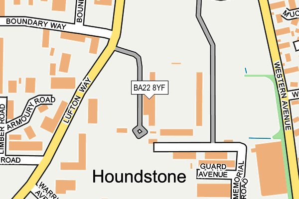
BA22 8YF is located in the Brympton electoral ward, within the unitary authority of Somerset and the English Parliamentary constituency of Yeovil. The Sub Integrated Care Board (ICB) Location is NHS Somerset ICB - 11X and the police force is Avon and Somerset. This postcode has been in use since June 1996.


GetTheData
Source: OS OpenMap – Local (Ordnance Survey)
Source: OS VectorMap District (Ordnance Survey)
Licence: Open Government Licence (requires attribution)
| Easting | 352700 |
| Northing | 116971 |
| Latitude | 50.950221 |
| Longitude | -2.674717 |
GetTheData
Source: Open Postcode Geo
Licence: Open Government Licence
| Country | England |
| Postcode District | BA22 |
➜ See where BA22 is on a map ➜ Where is Yeovil? | |
GetTheData
Source: Land Registry Price Paid Data
Licence: Open Government Licence
Elevation or altitude of BA22 8YF as distance above sea level:
| Metres | Feet | |
|---|---|---|
| Elevation | 90m | 295ft |
Elevation is measured from the approximate centre of the postcode, to the nearest point on an OS contour line from OS Terrain 50, which has contour spacing of ten vertical metres.
➜ How high above sea level am I? Find the elevation of your current position using your device's GPS.
GetTheData
Source: Open Postcode Elevation
Licence: Open Government Licence
| Ward | Brympton |
| Constituency | Yeovil |
GetTheData
Source: ONS Postcode Database
Licence: Open Government Licence
| Huish Park (Lufton Way) | Houndstone | 108m |
| Yeovil College Lufton Site | Yeovil | 172m |
| Yeovil College Lufton Site | Yeovil | 180m |
| Lufton Way | Houndstone | 203m |
| Lufton Way | Houndstone | 207m |
| Yeovil Pen Mill Station | 4.4km |
| Yeovil Junction Station | 5.2km |
GetTheData
Source: NaPTAN
Licence: Open Government Licence
GetTheData
Source: ONS Postcode Database
Licence: Open Government Licence


➜ Get more ratings from the Food Standards Agency
GetTheData
Source: Food Standards Agency
Licence: FSA terms & conditions
| Last Collection | |||
|---|---|---|---|
| Location | Mon-Fri | Sat | Distance |
| Grove Avenue | 16:00 | 12:00 | 377m |
| Westfield Post Office | 17:30 | 12:00 | 1,461m |
| Westfield Road | 17:30 | 12:00 | 1,534m |
GetTheData
Source: Dracos
Licence: Creative Commons Attribution-ShareAlike
The below table lists the International Territorial Level (ITL) codes (formerly Nomenclature of Territorial Units for Statistics (NUTS) codes) and Local Administrative Units (LAU) codes for BA22 8YF:
| ITL 1 Code | Name |
|---|---|
| TLK | South West (England) |
| ITL 2 Code | Name |
| TLK2 | Dorset and Somerset |
| ITL 3 Code | Name |
| TLK23 | Somerset CC |
| LAU 1 Code | Name |
| E07000189 | South Somerset |
GetTheData
Source: ONS Postcode Directory
Licence: Open Government Licence
The below table lists the Census Output Area (OA), Lower Layer Super Output Area (LSOA), and Middle Layer Super Output Area (MSOA) for BA22 8YF:
| Code | Name | |
|---|---|---|
| OA | E00166008 | |
| LSOA | E01029160 | South Somerset 012A |
| MSOA | E02006086 | South Somerset 012 |
GetTheData
Source: ONS Postcode Directory
Licence: Open Government Licence
| BA22 8PT | Lufton Way | 189m |
| BA22 8RL | Armoury Road | 247m |
| BA22 8RT | Mead Avenue | 280m |
| BA21 3TG | Kingsland Grange | 303m |
| BA21 3RB | Muchelney Way | 317m |
| BA21 3TQ | Westminster | 322m |
| BA22 8RR | Limber Road | 347m |
| BA21 3TE | Trellech Court | 359m |
| BA21 3QR | Forde Park | 376m |
| BA22 8YG | Termare Close | 384m |
GetTheData
Source: Open Postcode Geo; Land Registry Price Paid Data
Licence: Open Government Licence