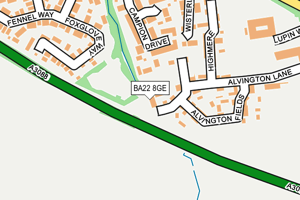
BA22 8GE lies on Alvington Lane in Brympton, Yeovil. BA22 8GE is located in the Brympton electoral ward, within the unitary authority of Somerset and the English Parliamentary constituency of Yeovil. The Sub Integrated Care Board (ICB) Location is NHS Somerset ICB - 11X and the police force is Avon and Somerset. This postcode has been in use since September 2005.


GetTheData
Source: OS OpenMap – Local (Ordnance Survey)
Source: OS VectorMap District (Ordnance Survey)
Licence: Open Government Licence (requires attribution)
| Easting | 352569 |
| Northing | 115935 |
| Latitude | 50.940887 |
| Longitude | -2.676448 |
GetTheData
Source: Open Postcode Geo
Licence: Open Government Licence
| Street | Alvington Lane |
| Locality | Brympton |
| Town/City | Yeovil |
| Country | England |
| Postcode District | BA22 |
➜ See where BA22 is on a map ➜ Where is Yeovil? | |
GetTheData
Source: Land Registry Price Paid Data
Licence: Open Government Licence
Elevation or altitude of BA22 8GE as distance above sea level:
| Metres | Feet | |
|---|---|---|
| Elevation | 60m | 197ft |
Elevation is measured from the approximate centre of the postcode, to the nearest point on an OS contour line from OS Terrain 50, which has contour spacing of ten vertical metres.
➜ How high above sea level am I? Find the elevation of your current position using your device's GPS.
GetTheData
Source: Open Postcode Elevation
Licence: Open Government Licence
| Ward | Brympton |
| Constituency | Yeovil |
GetTheData
Source: ONS Postcode Database
Licence: Open Government Licence
| Alvington Aerosystems (Alvington Lane) | Preston Plucknett | 190m |
| Bluebell Road | Alvington | 309m |
| Bluebell Road | Alvington | 325m |
| Houndstone (Preston Road) | Houndstone | 389m |
| Houndstone (Preston Road) | Houndstone | 395m |
| Yeovil Pen Mill Station | 4.4km |
| Yeovil Junction Station | 4.8km |
GetTheData
Source: NaPTAN
Licence: Open Government Licence
| Percentage of properties with Next Generation Access | 100.0% |
| Percentage of properties with Superfast Broadband | 100.0% |
| Percentage of properties with Ultrafast Broadband | 0.0% |
| Percentage of properties with Full Fibre Broadband | 0.0% |
Superfast Broadband is between 30Mbps and 300Mbps
Ultrafast Broadband is > 300Mbps
| Median download speed | 63.7Mbps |
| Average download speed | 45.2Mbps |
| Maximum download speed | 80.00Mbps |
| Median upload speed | 15.9Mbps |
| Average upload speed | 11.5Mbps |
| Maximum upload speed | 20.00Mbps |
| Percentage of properties unable to receive 2Mbps | 0.0% |
| Percentage of properties unable to receive 5Mbps | 0.0% |
| Percentage of properties unable to receive 10Mbps | 0.0% |
| Percentage of properties unable to receive 30Mbps | 0.0% |
GetTheData
Source: Ofcom
Licence: Ofcom Terms of Use (requires attribution)
GetTheData
Source: ONS Postcode Database
Licence: Open Government Licence

➜ Get more ratings from the Food Standards Agency
GetTheData
Source: Food Standards Agency
Licence: FSA terms & conditions
| Last Collection | |||
|---|---|---|---|
| Location | Mon-Fri | Sat | Distance |
| Grove Avenue | 16:00 | 12:00 | 741m |
| Westfield Post Office | 17:30 | 12:00 | 2,101m |
| Westfield Road | 17:30 | 12:00 | 2,161m |
GetTheData
Source: Dracos
Licence: Creative Commons Attribution-ShareAlike
The below table lists the International Territorial Level (ITL) codes (formerly Nomenclature of Territorial Units for Statistics (NUTS) codes) and Local Administrative Units (LAU) codes for BA22 8GE:
| ITL 1 Code | Name |
|---|---|
| TLK | South West (England) |
| ITL 2 Code | Name |
| TLK2 | Dorset and Somerset |
| ITL 3 Code | Name |
| TLK23 | Somerset CC |
| LAU 1 Code | Name |
| E07000189 | South Somerset |
GetTheData
Source: ONS Postcode Directory
Licence: Open Government Licence
The below table lists the Census Output Area (OA), Lower Layer Super Output Area (LSOA), and Middle Layer Super Output Area (MSOA) for BA22 8GE:
| Code | Name | |
|---|---|---|
| OA | E00166010 | |
| LSOA | E01029159 | South Somerset 018A |
| MSOA | E02006092 | South Somerset 018 |
GetTheData
Source: ONS Postcode Directory
Licence: Open Government Licence
| BA22 8TH | Alvington Lane | 108m |
| BA22 8AY | Alvington Fields | 132m |
| BA22 8QS | Campion Drive | 145m |
| BA22 8UT | Wisteria Close | 178m |
| BA22 8AL | Highmere | 193m |
| BA22 8PU | Foxglove Way | 203m |
| BA22 8SS | Celandine Road | 273m |
| BA22 8DZ | Heather Way | 308m |
| BA22 8SA | Fennel Way | 340m |
| BA22 8QT | Jasmine Close | 347m |
GetTheData
Source: Open Postcode Geo; Land Registry Price Paid Data
Licence: Open Government Licence