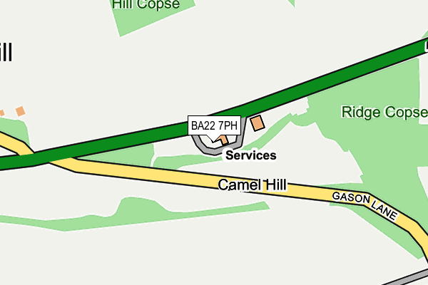
BA22 7PH lies on Camel Hill in Queen Camel, Yeovil. BA22 7PH is located in the Castle Cary electoral ward, within the unitary authority of Somerset and the English Parliamentary constituency of Somerton and Frome. The Sub Integrated Care Board (ICB) Location is NHS Somerset ICB - 11X and the police force is Avon and Somerset. This postcode has been in use since January 1980.


GetTheData
Source: OS OpenMap – Local (Ordnance Survey)
Source: OS VectorMap District (Ordnance Survey)
Licence: Open Government Licence (requires attribution)
| Easting | 359296 |
| Northing | 125592 |
| Latitude | 51.028238 |
| Longitude | -2.581797 |
GetTheData
Source: Open Postcode Geo
Licence: Open Government Licence
| Street | Camel Hill |
| Locality | Queen Camel |
| Town/City | Yeovil |
| Country | England |
| Postcode District | BA22 |
➜ See where BA22 is on a map | |
GetTheData
Source: Land Registry Price Paid Data
Licence: Open Government Licence
Elevation or altitude of BA22 7PH as distance above sea level:
| Metres | Feet | |
|---|---|---|
| Elevation | 70m | 230ft |
Elevation is measured from the approximate centre of the postcode, to the nearest point on an OS contour line from OS Terrain 50, which has contour spacing of ten vertical metres.
➜ How high above sea level am I? Find the elevation of your current position using your device's GPS.
GetTheData
Source: Open Postcode Elevation
Licence: Open Government Licence
| Ward | Castle Cary |
| Constituency | Somerton And Frome |
GetTheData
Source: ONS Postcode Database
Licence: Open Government Licence
| Camel Bridge | Queen Camel | 630m |
| Camel Bridge (A359) | Queen Camel | 643m |
| Wolfester Terrace | Sparkford | 705m |
| Wolfester Terrace | Sparkford | 714m |
| Countess Gytha School (High Street) | Queen Camel | 728m |
GetTheData
Source: NaPTAN
Licence: Open Government Licence
GetTheData
Source: ONS Postcode Database
Licence: Open Government Licence


➜ Get more ratings from the Food Standards Agency
GetTheData
Source: Food Standards Agency
Licence: FSA terms & conditions
| Last Collection | |||
|---|---|---|---|
| Location | Mon-Fri | Sat | Distance |
| Hazelgrove Service Station | 16:15 | 12:00 | 614m |
| Lower Foddington | 11:15 | 11:15 | 3,732m |
| South Cadbury | 16:15 | 09:00 | 3,947m |
GetTheData
Source: Dracos
Licence: Creative Commons Attribution-ShareAlike
The below table lists the International Territorial Level (ITL) codes (formerly Nomenclature of Territorial Units for Statistics (NUTS) codes) and Local Administrative Units (LAU) codes for BA22 7PH:
| ITL 1 Code | Name |
|---|---|
| TLK | South West (England) |
| ITL 2 Code | Name |
| TLK2 | Dorset and Somerset |
| ITL 3 Code | Name |
| TLK23 | Somerset CC |
| LAU 1 Code | Name |
| E07000189 | South Somerset |
GetTheData
Source: ONS Postcode Directory
Licence: Open Government Licence
The below table lists the Census Output Area (OA), Lower Layer Super Output Area (LSOA), and Middle Layer Super Output Area (MSOA) for BA22 7PH:
| Code | Name | |
|---|---|---|
| OA | E00148562 | |
| LSOA | E01029164 | South Somerset 006A |
| MSOA | E02006080 | South Somerset 006 |
GetTheData
Source: ONS Postcode Directory
Licence: Open Government Licence
| BA22 7PQ | Gason Lane | 330m |
| BA22 7PG | West View | 507m |
| BA22 7PE | Hill View | 601m |
| BA22 7PJ | 629m | |
| BA22 7JE | 680m | |
| BA22 7JF | 684m | |
| BA22 7PD | Eyewell Cottages | 712m |
| BA22 7NU | Laurel Lane | 718m |
| BA22 7NH | High Street | 730m |
| BA22 7NT | 752m |
GetTheData
Source: Open Postcode Geo; Land Registry Price Paid Data
Licence: Open Government Licence