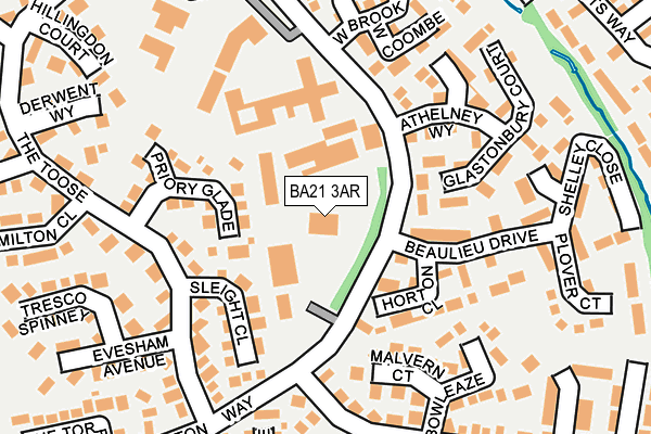
BA21 3AR is located in the Brympton electoral ward, within the unitary authority of Somerset and the English Parliamentary constituency of Yeovil. The Sub Integrated Care Board (ICB) Location is NHS Somerset ICB - 11X and the police force is Avon and Somerset. This postcode has been in use since January 1980.


GetTheData
Source: OS OpenMap – Local (Ordnance Survey)
Source: OS VectorMap District (Ordnance Survey)
Licence: Open Government Licence (requires attribution)
| Easting | 353457 |
| Northing | 116789 |
| Latitude | 50.948639 |
| Longitude | -2.663919 |
GetTheData
Source: Open Postcode Geo
Licence: Open Government Licence
| Country | England |
| Postcode District | BA21 |
➜ See where BA21 is on a map ➜ Where is Yeovil? | |
GetTheData
Source: Land Registry Price Paid Data
Licence: Open Government Licence
Elevation or altitude of BA21 3AR as distance above sea level:
| Metres | Feet | |
|---|---|---|
| Elevation | 80m | 262ft |
Elevation is measured from the approximate centre of the postcode, to the nearest point on an OS contour line from OS Terrain 50, which has contour spacing of ten vertical metres.
➜ How high above sea level am I? Find the elevation of your current position using your device's GPS.
GetTheData
Source: Open Postcode Elevation
Licence: Open Government Licence
| Ward | Brympton |
| Constituency | Yeovil |
GetTheData
Source: ONS Postcode Database
Licence: Open Government Licence
| Beaulieu Drive (Stourton Way) | Houndstone | 119m |
| Stourton Way (West Brook) | Houndstone | 148m |
| The Forum (Stourton Way) | Preston Plucknett | 163m |
| The Forum (Stourton Way) | Houndstone | 172m |
| The Toose (Stourton Way) | Preston Plucknett | 181m |
| Yeovil Pen Mill Station | 3.6km |
| Yeovil Junction Station | 4.5km |
GetTheData
Source: NaPTAN
Licence: Open Government Licence
GetTheData
Source: ONS Postcode Database
Licence: Open Government Licence


➜ Get more ratings from the Food Standards Agency
GetTheData
Source: Food Standards Agency
Licence: FSA terms & conditions
| Last Collection | |||
|---|---|---|---|
| Location | Mon-Fri | Sat | Distance |
| Westfield Post Office | 17:30 | 12:00 | 869m |
| Westfield Road | 17:30 | 12:00 | 931m |
| Grove Avenue | 16:00 | 12:00 | 991m |
GetTheData
Source: Dracos
Licence: Creative Commons Attribution-ShareAlike
The below table lists the International Territorial Level (ITL) codes (formerly Nomenclature of Territorial Units for Statistics (NUTS) codes) and Local Administrative Units (LAU) codes for BA21 3AR:
| ITL 1 Code | Name |
|---|---|
| TLK | South West (England) |
| ITL 2 Code | Name |
| TLK2 | Dorset and Somerset |
| ITL 3 Code | Name |
| TLK23 | Somerset CC |
| LAU 1 Code | Name |
| E07000189 | South Somerset |
GetTheData
Source: ONS Postcode Directory
Licence: Open Government Licence
The below table lists the Census Output Area (OA), Lower Layer Super Output Area (LSOA), and Middle Layer Super Output Area (MSOA) for BA21 3AR:
| Code | Name | |
|---|---|---|
| OA | E00148543 | |
| LSOA | E01029162 | South Somerset 013B |
| MSOA | E02006087 | South Somerset 013 |
GetTheData
Source: ONS Postcode Directory
Licence: Open Government Licence
| BA21 3SQ | Priory Glade | 76m |
| BA21 3SW | Sleight Close | 129m |
| BA21 3TR | Beaulieu Drive | 131m |
| BA21 3TL | The Forum | 144m |
| BA21 3SN | The Toose | 172m |
| BA21 3TW | Glastonbury Court | 173m |
| BA21 3TS | Horton Close | 176m |
| BA21 3RZ | Malvern Court | 181m |
| BA21 3UE | West Coombe | 191m |
| BA21 3UD | West Brook | 193m |
GetTheData
Source: Open Postcode Geo; Land Registry Price Paid Data
Licence: Open Government Licence