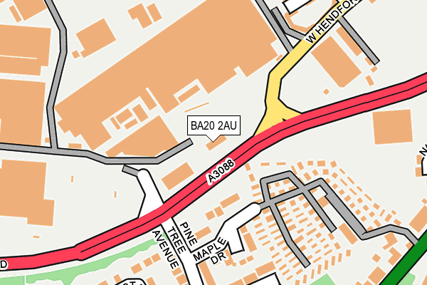
BA20 2AU is located in the Yeovil South electoral ward, within the unitary authority of Somerset and the English Parliamentary constituency of Yeovil. The Sub Integrated Care Board (ICB) Location is NHS Somerset ICB - 11X and the police force is Avon and Somerset. This postcode has been in use since December 1995.


GetTheData
Source: OS OpenMap – Local (Ordnance Survey)
Source: OS VectorMap District (Ordnance Survey)
Licence: Open Government Licence (requires attribution)
| Easting | 354787 |
| Northing | 115351 |
| Latitude | 50.935814 |
| Longitude | -2.644808 |
GetTheData
Source: Open Postcode Geo
Licence: Open Government Licence
| Country | England |
| Postcode District | BA20 |
➜ See where BA20 is on a map ➜ Where is Yeovil? | |
GetTheData
Source: Land Registry Price Paid Data
Licence: Open Government Licence
Elevation or altitude of BA20 2AU as distance above sea level:
| Metres | Feet | |
|---|---|---|
| Elevation | 40m | 131ft |
Elevation is measured from the approximate centre of the postcode, to the nearest point on an OS contour line from OS Terrain 50, which has contour spacing of ten vertical metres.
➜ How high above sea level am I? Find the elevation of your current position using your device's GPS.
GetTheData
Source: Open Postcode Elevation
Licence: Open Government Licence
| Ward | Yeovil South |
| Constituency | Yeovil |
GetTheData
Source: ONS Postcode Database
Licence: Open Government Licence
| Pc World (A3088) | Yeovil | 143m |
| Pine Tree Avenue | Yeovil | 149m |
| Pine Tree Avenue (Maple Drive) | Yeovil | 176m |
| Morrisons Supermarket | Yeovil | 244m |
| Rowan Way | Yeovil | 255m |
| Yeovil Pen Mill Station | 2.4km |
| Yeovil Junction Station | 2.6km |
| Thornford Station | 5.4km |
GetTheData
Source: NaPTAN
Licence: Open Government Licence
GetTheData
Source: ONS Postcode Database
Licence: Open Government Licence


➜ Get more ratings from the Food Standards Agency
GetTheData
Source: Food Standards Agency
Licence: FSA terms & conditions
| Last Collection | |||
|---|---|---|---|
| Location | Mon-Fri | Sat | Distance |
| Orchard Street Post Office | 17:30 | 12:00 | 655m |
| Manor Road | 17:30 | 12:00 | 712m |
| Yeovil Delivery Office | 18:00 | 12:00 | 751m |
GetTheData
Source: Dracos
Licence: Creative Commons Attribution-ShareAlike
| Risk of BA20 2AU flooding from rivers and sea | Medium |
| ➜ BA20 2AU flood map | |
GetTheData
Source: Open Flood Risk by Postcode
Licence: Open Government Licence
The below table lists the International Territorial Level (ITL) codes (formerly Nomenclature of Territorial Units for Statistics (NUTS) codes) and Local Administrative Units (LAU) codes for BA20 2AU:
| ITL 1 Code | Name |
|---|---|
| TLK | South West (England) |
| ITL 2 Code | Name |
| TLK2 | Dorset and Somerset |
| ITL 3 Code | Name |
| TLK23 | Somerset CC |
| LAU 1 Code | Name |
| E07000189 | South Somerset |
GetTheData
Source: ONS Postcode Directory
Licence: Open Government Licence
The below table lists the Census Output Area (OA), Lower Layer Super Output Area (LSOA), and Middle Layer Super Output Area (MSOA) for BA20 2AU:
| Code | Name | |
|---|---|---|
| OA | E00148969 | |
| LSOA | E01029242 | South Somerset 018B |
| MSOA | E02006092 | South Somerset 018 |
GetTheData
Source: ONS Postcode Directory
Licence: Open Government Licence
| BA20 2NW | Maple Drive | 121m |
| BA20 2NN | Pine Tree Avenue | 190m |
| BA20 2RQ | Hendford Hill | 215m |
| BA20 2NS | Rowan Way | 230m |
| BA20 2NL | Chestnut Drive | 248m |
| BA20 2FW | Fosse Park Road | 278m |
| BA20 2NR | Rowan Way | 282m |
| BA20 2RG | Hendford Hill | 294m |
| BA20 2AG | West Hendford | 296m |
| BA20 2AZ | Westland Road | 303m |
GetTheData
Source: Open Postcode Geo; Land Registry Price Paid Data
Licence: Open Government Licence