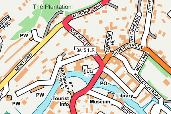
BA15 1LR is located in the Bradford-on-Avon South electoral ward, within the unitary authority of Wiltshire and the English Parliamentary constituency of Chippenham. The Sub Integrated Care Board (ICB) Location is NHS Bath and North East Somerset, Swindon and Wiltshire ICB - 92 and the police force is Wiltshire. This postcode has been in use since June 1999.


GetTheData
Source: OS OpenMap – Local (Ordnance Survey)
Source: OS VectorMap District (Ordnance Survey)
Licence: Open Government Licence (requires attribution)
| Easting | 382586 |
| Northing | 160987 |
| Latitude | 51.347693 |
| Longitude | -2.251423 |
GetTheData
Source: Open Postcode Geo
Licence: Open Government Licence
| Country | England |
| Postcode District | BA15 |
➜ See where BA15 is on a map ➜ Where is Bradford-on-Avon? | |
GetTheData
Source: Land Registry Price Paid Data
Licence: Open Government Licence
Elevation or altitude of BA15 1LR as distance above sea level:
| Metres | Feet | |
|---|---|---|
| Elevation | 30m | 98ft |
Elevation is measured from the approximate centre of the postcode, to the nearest point on an OS contour line from OS Terrain 50, which has contour spacing of ten vertical metres.
➜ How high above sea level am I? Find the elevation of your current position using your device's GPS.
GetTheData
Source: Open Postcode Elevation
Licence: Open Government Licence
| Ward | Bradford-on-avon South |
| Constituency | Chippenham |
GetTheData
Source: ONS Postcode Database
Licence: Open Government Licence
| Town Bridge (Silver Street) | Bradford-on-avon | 107m |
| Town Bridge (Silver Street) | Bradford-on-avon | 117m |
| Ropewalk (Newtown) | Bradford-on-avon | 252m |
| Ropewalk (Newtown) | Bradford-on-avon | 258m |
| United Church (St Margarets Street) | Bradford-on-avon | 269m |
| Bradford-on-Avon Station | 0.3km |
| Avoncliff Station | 2.3km |
| Freshford Station | 3.5km |
GetTheData
Source: NaPTAN
Licence: Open Government Licence
GetTheData
Source: ONS Postcode Database
Licence: Open Government Licence


➜ Get more ratings from the Food Standards Agency
GetTheData
Source: Food Standards Agency
Licence: FSA terms & conditions
| Last Collection | |||
|---|---|---|---|
| Location | Mon-Fri | Sat | Distance |
| Bradford On Avon Post Office | 17:15 | 12:15 | 40m |
| Station Approach | 17:15 | 11:30 | 249m |
| Winsley Road P.o. | 17:15 | 12:00 | 393m |
GetTheData
Source: Dracos
Licence: Creative Commons Attribution-ShareAlike
| Risk of BA15 1LR flooding from rivers and sea | Medium |
| ➜ BA15 1LR flood map | |
GetTheData
Source: Open Flood Risk by Postcode
Licence: Open Government Licence
The below table lists the International Territorial Level (ITL) codes (formerly Nomenclature of Territorial Units for Statistics (NUTS) codes) and Local Administrative Units (LAU) codes for BA15 1LR:
| ITL 1 Code | Name |
|---|---|
| TLK | South West (England) |
| ITL 2 Code | Name |
| TLK1 | Gloucestershire, Wiltshire and Bath/Bristol area |
| ITL 3 Code | Name |
| TLK15 | Wiltshire |
| LAU 1 Code | Name |
| E06000054 | Wiltshire |
GetTheData
Source: ONS Postcode Directory
Licence: Open Government Licence
The below table lists the Census Output Area (OA), Lower Layer Super Output Area (LSOA), and Middle Layer Super Output Area (MSOA) for BA15 1LR:
| Code | Name | |
|---|---|---|
| OA | E00163463 | |
| LSOA | E01032050 | Wiltshire 027F |
| MSOA | E02006682 | Wiltshire 027 |
GetTheData
Source: ONS Postcode Directory
Licence: Open Government Licence
| BA15 1LJ | Market Street | 50m |
| BA15 1LH | Market Street | 53m |
| BA15 1LL | Market Street | 68m |
| BA15 1LN | Church Street | 75m |
| BA15 1JX | Silver Street | 77m |
| BA15 1HB | Church Street | 85m |
| BA15 1JT | Coppice Hill | 99m |
| BA15 1FG | Lamb Yard | 122m |
| BA15 1JY | Silver Street | 132m |
| BA15 1EJ | Bridge Yard | 134m |
GetTheData
Source: Open Postcode Geo; Land Registry Price Paid Data
Licence: Open Government Licence