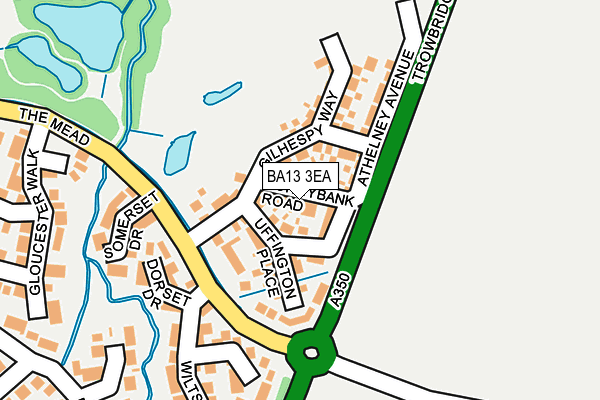
BA13 3EA is located in the Westbury North electoral ward, within the unitary authority of Wiltshire and the English Parliamentary constituency of South West Wiltshire. The Sub Integrated Care Board (ICB) Location is NHS Bath and North East Somerset, Swindon and Wiltshire ICB - 92 and the police force is Wiltshire. This postcode has been in use since March 2017.


GetTheData
Source: OS OpenMap – Local (Ordnance Survey)
Source: OS VectorMap District (Ordnance Survey)
Licence: Open Government Licence (requires attribution)
| Easting | 387486 |
| Northing | 152111 |
| Latitude | 51.268008 |
| Longitude | -2.180749 |
GetTheData
Source: Open Postcode Geo
Licence: Open Government Licence
| Country | England |
| Postcode District | BA13 |
➜ See where BA13 is on a map ➜ Where is Westbury? | |
GetTheData
Source: Land Registry Price Paid Data
Licence: Open Government Licence
| Ward | Westbury North |
| Constituency | South West Wiltshire |
GetTheData
Source: ONS Postcode Database
Licence: Open Government Licence
2019 16 AUG £247,500 |
11, SUNNYBANK ROAD, WESTBURY, BA13 3EA 2017 9 JUN £244,995 |
5, SUNNYBANK ROAD, WESTBURY, BA13 3EA 2017 1 JUN £284,995 |
3, SUNNYBANK ROAD, WESTBURY, BA13 3EA 2017 26 MAY £234,995 |
7, SUNNYBANK ROAD, WESTBURY, BA13 3EA 2017 5 MAY £284,995 |
9, SUNNYBANK ROAD, WESTBURY, BA13 3EA 2017 28 APR £284,995 |
4, SUNNYBANK ROAD, WESTBURY, BA13 3EA 2017 17 MAR £282,995 |
2017 10 MAR £242,995 |
GetTheData
Source: HM Land Registry Price Paid Data
Licence: Contains HM Land Registry data © Crown copyright and database right 2025. This data is licensed under the Open Government Licence v3.0.
| The Mead | Westbury | 119m |
| The Mead | Westbury | 139m |
| Co-op Supermarket (Trwobridge Road) | Westbury | 237m |
| Field Close (Meadow Lane) | Westbury | 404m |
| Bitham Park | Westbury | 405m |
| Westbury (Wilts) Station | 1.3km |
| Dilton Marsh Station | 2.8km |
GetTheData
Source: NaPTAN
Licence: Open Government Licence
| Percentage of properties with Next Generation Access | 100.0% |
| Percentage of properties with Superfast Broadband | 100.0% |
| Percentage of properties with Ultrafast Broadband | 100.0% |
| Percentage of properties with Full Fibre Broadband | 100.0% |
Superfast Broadband is between 30Mbps and 300Mbps
Ultrafast Broadband is > 300Mbps
| Percentage of properties unable to receive 2Mbps | 0.0% |
| Percentage of properties unable to receive 5Mbps | 0.0% |
| Percentage of properties unable to receive 10Mbps | 0.0% |
| Percentage of properties unable to receive 30Mbps | 0.0% |
GetTheData
Source: Ofcom
Licence: Ofcom Terms of Use (requires attribution)
GetTheData
Source: ONS Postcode Database
Licence: Open Government Licence


➜ Get more ratings from the Food Standards Agency
GetTheData
Source: Food Standards Agency
Licence: FSA terms & conditions
| Last Collection | |||
|---|---|---|---|
| Location | Mon-Fri | Sat | Distance |
| The Mead | 17:00 | 12:15 | 234m |
| Arundell Close | 17:00 | 12:15 | 407m |
| Market Place | 17:30 | 12:00 | 618m |
GetTheData
Source: Dracos
Licence: Creative Commons Attribution-ShareAlike
The below table lists the International Territorial Level (ITL) codes (formerly Nomenclature of Territorial Units for Statistics (NUTS) codes) and Local Administrative Units (LAU) codes for BA13 3EA:
| ITL 1 Code | Name |
|---|---|
| TLK | South West (England) |
| ITL 2 Code | Name |
| TLK1 | Gloucestershire, Wiltshire and Bath/Bristol area |
| ITL 3 Code | Name |
| TLK15 | Wiltshire |
| LAU 1 Code | Name |
| E06000054 | Wiltshire |
GetTheData
Source: ONS Postcode Directory
Licence: Open Government Licence
The below table lists the Census Output Area (OA), Lower Layer Super Output Area (LSOA), and Middle Layer Super Output Area (MSOA) for BA13 3EA:
| Code | Name | |
|---|---|---|
| OA | E00163820 | |
| LSOA | E01032116 | Wiltshire 040B |
| MSOA | E02006691 | Wiltshire 040 |
GetTheData
Source: ONS Postcode Directory
Licence: Open Government Licence
| BA13 3XB | Dorset Drive | 148m |
| BA13 3XA | Somerset Drive | 176m |
| BA13 3XE | Hampshire Gardens | 182m |
| BA13 3XD | Wiltshire Way | 260m |
| BA13 3XF | Gloucester Walk | 263m |
| BA13 3AJ | Sarum Gardens | 265m |
| BA13 3XL | Teal Close | 291m |
| BA13 3XY | Nightingale Drive | 314m |
| BA13 3AB | Frogmore Road | 315m |
| BA13 3XG | Gloucester Walk | 317m |
GetTheData
Source: Open Postcode Geo; Land Registry Price Paid Data
Licence: Open Government Licence