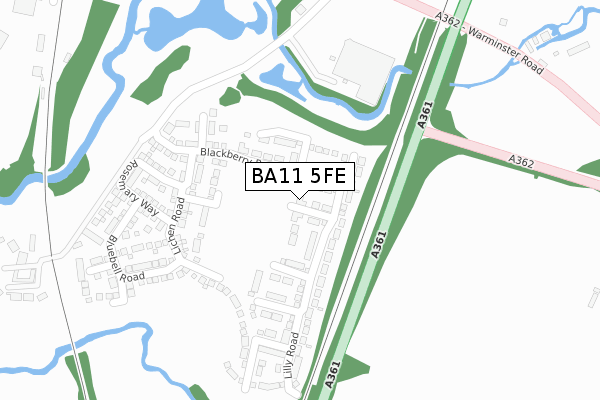
BA11 5FE is located in the Frome East electoral ward, within the unitary authority of Somerset and the English Parliamentary constituency of Somerton and Frome. The Sub Integrated Care Board (ICB) Location is NHS Somerset ICB - 11X and the police force is Avon and Somerset. This postcode has been in use since June 2018.


GetTheData
Source: OS Open Zoomstack (Ordnance Survey)
Licence: Open Government Licence (requires attribution)
Attribution: Contains OS data © Crown copyright and database right 2024
Source: Open Postcode Geo
Licence: Open Government Licence (requires attribution)
Attribution: Contains OS data © Crown copyright and database right 2024; Contains Royal Mail data © Royal Mail copyright and database right 2024; Source: Office for National Statistics licensed under the Open Government Licence v.3.0
| Easting | 378832 |
| Northing | 147179 |
| Latitude | 51.223402 |
| Longitude | -2.304497 |
GetTheData
Source: Open Postcode Geo
Licence: Open Government Licence
| Country | England |
| Postcode District | BA11 |
➜ See where BA11 is on a map ➜ Where is Frome? | |
GetTheData
Source: Land Registry Price Paid Data
Licence: Open Government Licence
| Ward | Frome East |
| Constituency | Somerton And Frome |
GetTheData
Source: ONS Postcode Database
Licence: Open Government Licence
27, MARIGOLD ROAD, FROME, BA11 5FE 2020 30 JUN £309,995 |
25, MARIGOLD ROAD, FROME, BA11 5FE 2019 30 MAY £279,995 |
2, MARIGOLD ROAD, FROME, BA11 5FE 2018 4 JUL £283,995 |
GetTheData
Source: HM Land Registry Price Paid Data
Licence: Contains HM Land Registry data © Crown copyright and database right 2024. This data is licensed under the Open Government Licence v3.0.
| Asda Superstore (Warminster Road) | Rodden | 399m |
| Asda Superstore (Warminster Road) | Rodden | 411m |
| Wallbridge (Styles Hill) | Berkley Down | 592m |
| Frome Station (Station Approach) | Keyford | 595m |
| Wallbridge (A362) | Frome | 612m |
| Frome Station | 0.6km |
GetTheData
Source: NaPTAN
Licence: Open Government Licence
| Percentage of properties with Next Generation Access | 100.0% |
| Percentage of properties with Superfast Broadband | 100.0% |
| Percentage of properties with Ultrafast Broadband | 100.0% |
| Percentage of properties with Full Fibre Broadband | 100.0% |
Superfast Broadband is between 30Mbps and 300Mbps
Ultrafast Broadband is > 300Mbps
| Percentage of properties unable to receive 2Mbps | 0.0% |
| Percentage of properties unable to receive 5Mbps | 0.0% |
| Percentage of properties unable to receive 10Mbps | 0.0% |
| Percentage of properties unable to receive 30Mbps | 0.0% |
GetTheData
Source: Ofcom
Licence: Ofcom Terms of Use (requires attribution)
GetTheData
Source: ONS Postcode Database
Licence: Open Government Licence


➜ Get more ratings from the Food Standards Agency
GetTheData
Source: Food Standards Agency
Licence: FSA terms & conditions
| Last Collection | |||
|---|---|---|---|
| Location | Mon-Fri | Sat | Distance |
| Wallbridge Post Office | 16:45 | 12:00 | 300m |
| Locks Hill | 17:30 | 12:00 | 867m |
| Portway Post Office | 17:15 | 12:00 | 1,004m |
GetTheData
Source: Dracos
Licence: Creative Commons Attribution-ShareAlike
The below table lists the International Territorial Level (ITL) codes (formerly Nomenclature of Territorial Units for Statistics (NUTS) codes) and Local Administrative Units (LAU) codes for BA11 5FE:
| ITL 1 Code | Name |
|---|---|
| TLK | South West (England) |
| ITL 2 Code | Name |
| TLK2 | Dorset and Somerset |
| ITL 3 Code | Name |
| TLK23 | Somerset CC |
| LAU 1 Code | Name |
| E07000187 | Mendip |
GetTheData
Source: ONS Postcode Directory
Licence: Open Government Licence
The below table lists the Census Output Area (OA), Lower Layer Super Output Area (LSOA), and Middle Layer Super Output Area (MSOA) for BA11 5FE:
| Code | Name | |
|---|---|---|
| OA | E00147871 | |
| LSOA | E01029035 | Mendip 007B |
| MSOA | E02006053 | Mendip 007 |
GetTheData
Source: ONS Postcode Directory
Licence: Open Government Licence
| BA11 5LA | Warminster Road | 443m |
| BA11 5LB | 464m | |
| BA11 5LE | 482m | |
| BA11 5JU | The Retreat | 571m |
| BA11 1FS | Providence Court | 598m |
| BA11 5AL | Styles Park | 608m |
| BA11 5JW | East Hill | 612m |
| BA11 1NE | Caxton Road | 632m |
| BA11 1QZ | Wallbridge | 648m |
| BA11 5JX | Wallbridge | 648m |
GetTheData
Source: Open Postcode Geo; Land Registry Price Paid Data
Licence: Open Government Licence