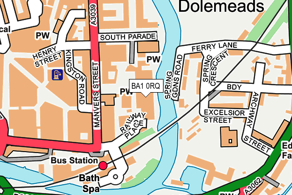
BA1 0RQ is located in the Kingsmead electoral ward, within the unitary authority of Bath and North East Somerset and the English Parliamentary constituency of Bath. The Sub Integrated Care Board (ICB) Location is NHS Bath and North East Somerset, Swindon and Wiltshire ICB - 92 and the police force is Avon and Somerset. This postcode has been in use since October 2013.


GetTheData
Source: OS OpenMap – Local (Ordnance Survey)
Source: OS VectorMap District (Ordnance Survey)
Licence: Open Government Licence (requires attribution)
| Easting | 375350 |
| Northing | 164482 |
| Latitude | 51.378849 |
| Longitude | -2.355562 |
GetTheData
Source: Open Postcode Geo
Licence: Open Government Licence
| Country | England |
| Postcode District | BA1 |
➜ See where BA1 is on a map ➜ Where is Bath? | |
GetTheData
Source: Land Registry Price Paid Data
Licence: Open Government Licence
Elevation or altitude of BA1 0RQ as distance above sea level:
| Metres | Feet | |
|---|---|---|
| Elevation | 20m | 66ft |
Elevation is measured from the approximate centre of the postcode, to the nearest point on an OS contour line from OS Terrain 50, which has contour spacing of ten vertical metres.
➜ How high above sea level am I? Find the elevation of your current position using your device's GPS.
GetTheData
Source: Open Postcode Elevation
Licence: Open Government Licence
| Ward | Kingsmead |
| Constituency | Bath |
GetTheData
Source: ONS Postcode Database
Licence: Open Government Licence
| Manvers Street | Bath City Centre | 107m |
| Manvers Street | Bath City Centre | 111m |
| Manvers Street | Bath City Centre | 122m |
| Dorchester Street | Bath City Centre | 179m |
| Dorchester Street | Bath City Centre | 192m |
| Bath Spa Station | 0.2km |
| Oldfield Park Station | 1.7km |
| Freshford Station | 5.6km |
GetTheData
Source: NaPTAN
Licence: Open Government Licence
GetTheData
Source: ONS Postcode Database
Licence: Open Government Licence


➜ Get more ratings from the Food Standards Agency
GetTheData
Source: Food Standards Agency
Licence: FSA terms & conditions
| Last Collection | |||
|---|---|---|---|
| Location | Mon-Fri | Sat | Distance |
| Bath Delivery Office | 18:30 | 13:00 | 106m |
| Bath Spa Station | 17:30 | 11:30 | 166m |
| Bath Spa Station | 17:30 | 11:30 | 173m |
GetTheData
Source: Dracos
Licence: Creative Commons Attribution-ShareAlike
| Risk of BA1 0RQ flooding from rivers and sea | Medium |
| ➜ BA1 0RQ flood map | |
GetTheData
Source: Open Flood Risk by Postcode
Licence: Open Government Licence
The below table lists the International Territorial Level (ITL) codes (formerly Nomenclature of Territorial Units for Statistics (NUTS) codes) and Local Administrative Units (LAU) codes for BA1 0RQ:
| ITL 1 Code | Name |
|---|---|
| TLK | South West (England) |
| ITL 2 Code | Name |
| TLK1 | Gloucestershire, Wiltshire and Bath/Bristol area |
| ITL 3 Code | Name |
| TLK12 | Bath and North East Somerset, North Somerset and South Gloucestershire |
| LAU 1 Code | Name |
| E06000022 | Bath and North East Somerset |
GetTheData
Source: ONS Postcode Directory
Licence: Open Government Licence
The below table lists the Census Output Area (OA), Lower Layer Super Output Area (LSOA), and Middle Layer Super Output Area (MSOA) for BA1 0RQ:
| Code | Name | |
|---|---|---|
| OA | E00072575 | |
| LSOA | E01014371 | Bath and North East Somerset 007B |
| MSOA | E02002991 | Bath and North East Somerset 007 |
GetTheData
Source: ONS Postcode Directory
Licence: Open Government Licence
| BA2 4HY | Spring Gardens Road | 83m |
| BA1 1PQ | Kingston Road | 118m |
| BA1 1JQ | Manvers Street | 123m |
| BA2 4HS | Ferry Lane | 129m |
| BA2 4HZ | Spring Crescent | 142m |
| BA1 1JH | Manvers Street | 144m |
| BA2 4AD | South Parade | 150m |
| BA2 4JB | Excelsior Street | 160m |
| BA2 4AR | Duke Street | 166m |
| BA2 4AA | South Parade | 173m |
GetTheData
Source: Open Postcode Geo; Land Registry Price Paid Data
Licence: Open Government Licence