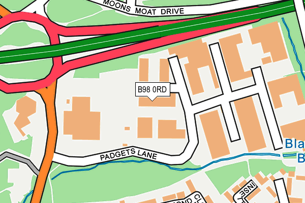
B98 0RD lies on Padgets Lane in Redditch. B98 0RD is located in the Winyates electoral ward, within the local authority district of Redditch and the English Parliamentary constituency of Redditch. The Sub Integrated Care Board (ICB) Location is NHS Herefordshire and Worcestershire ICB - 18C and the police force is West Mercia. This postcode has been in use since January 1980.


GetTheData
Source: OS OpenMap – Local (Ordnance Survey)
Source: OS VectorMap District (Ordnance Survey)
Licence: Open Government Licence (requires attribution)
| Easting | 406811 |
| Northing | 267901 |
| Latitude | 52.309197 |
| Longitude | -1.901514 |
GetTheData
Source: Open Postcode Geo
Licence: Open Government Licence
| Street | Padgets Lane |
| Town/City | Redditch |
| Country | England |
| Postcode District | B98 |
➜ See where B98 is on a map ➜ Where is Redditch? | |
GetTheData
Source: Land Registry Price Paid Data
Licence: Open Government Licence
Elevation or altitude of B98 0RD as distance above sea level:
| Metres | Feet | |
|---|---|---|
| Elevation | 90m | 295ft |
Elevation is measured from the approximate centre of the postcode, to the nearest point on an OS contour line from OS Terrain 50, which has contour spacing of ten vertical metres.
➜ How high above sea level am I? Find the elevation of your current position using your device's GPS.
GetTheData
Source: Open Postcode Elevation
Licence: Open Government Licence
| Ward | Winyates |
| Constituency | Redditch |
GetTheData
Source: ONS Postcode Database
Licence: Open Government Licence
| South & East Moons Moat (Winyates Way) | Moon's Moat | 283m |
| South & East Moons Moat (Winyates Way) | Moon's Moat | 303m |
| Arrow Valley Park (Battens Drive) | Winyates | 411m |
| North Moons Moat (Winyates Way) | Moon's Moat | 422m |
| North Moons Moat (Winyates Way) | Moon's Moat | 434m |
| Redditch Station | 3km |
| Wood End Station | 5.5km |
| Alvechurch Station | 6.1km |
GetTheData
Source: NaPTAN
Licence: Open Government Licence
| Median download speed | 58.3Mbps |
| Average download speed | 58.8Mbps |
| Maximum download speed | 80.00Mbps |
| Median upload speed | 12.2Mbps |
| Average upload speed | 14.5Mbps |
| Maximum upload speed | 20.00Mbps |
GetTheData
Source: Ofcom
Licence: Ofcom Terms of Use (requires attribution)
Estimated total energy consumption in B98 0RD by fuel type, 2015.
| Consumption (kWh) | 165,630 |
|---|---|
| Meter count | 11 |
| Mean (kWh/meter) | 15,057 |
| Median (kWh/meter) | 16,449 |
GetTheData
Source: Postcode level gas estimates: 2015 (experimental)
Source: Postcode level electricity estimates: 2015 (experimental)
Licence: Open Government Licence
GetTheData
Source: ONS Postcode Database
Licence: Open Government Licence


➜ Get more ratings from the Food Standards Agency
GetTheData
Source: Food Standards Agency
Licence: FSA terms & conditions
| Last Collection | |||
|---|---|---|---|
| Location | Mon-Fri | Sat | Distance |
| Ibstock Close / Whitehouse Lan | 17:30 | 11:30 | 727m |
| Churchill Post Office | 17:30 | 12:00 | 863m |
| Impney Drive / Home Meadow Lan | 17:30 | 10:30 | 1,102m |
GetTheData
Source: Dracos
Licence: Creative Commons Attribution-ShareAlike
| Risk of B98 0RD flooding from rivers and sea | Medium |
| ➜ B98 0RD flood map | |
GetTheData
Source: Open Flood Risk by Postcode
Licence: Open Government Licence
The below table lists the International Territorial Level (ITL) codes (formerly Nomenclature of Territorial Units for Statistics (NUTS) codes) and Local Administrative Units (LAU) codes for B98 0RD:
| ITL 1 Code | Name |
|---|---|
| TLG | West Midlands (England) |
| ITL 2 Code | Name |
| TLG1 | Herefordshire, Worcestershire and Warwickshire |
| ITL 3 Code | Name |
| TLG12 | Worcestershire CC |
| LAU 1 Code | Name |
| E07000236 | Redditch |
GetTheData
Source: ONS Postcode Directory
Licence: Open Government Licence
The below table lists the Census Output Area (OA), Lower Layer Super Output Area (LSOA), and Middle Layer Super Output Area (MSOA) for B98 0RD:
| Code | Name | |
|---|---|---|
| OA | E00164629 | |
| LSOA | E01032274 | Redditch 007D |
| MSOA | E02006727 | Redditch 007 |
GetTheData
Source: ONS Postcode Directory
Licence: Open Government Licence
| B98 9JF | Arley Close | 212m |
| B98 9HP | Acton Close | 235m |
| B98 0JQ | Edgmond Close | 281m |
| B98 0JJ | Insetton Close | 297m |
| B98 9JE | Barnwood Close | 300m |
| B98 0JG | Edgmond Close | 315m |
| B98 0LL | Jakemans Close | 328m |
| B98 9HR | Cleeve Close | 336m |
| B98 0JF | Caynham Close | 362m |
| B98 9JB | Exhall Close | 366m |
GetTheData
Source: Open Postcode Geo; Land Registry Price Paid Data
Licence: Open Government Licence