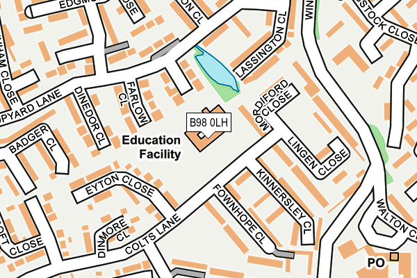
B98 0LH is located in the Winyates electoral ward, within the local authority district of Redditch and the English Parliamentary constituency of Redditch. The Sub Integrated Care Board (ICB) Location is NHS Herefordshire and Worcestershire ICB - 18C and the police force is West Mercia. This postcode has been in use since January 1980.


GetTheData
Source: OS OpenMap – Local (Ordnance Survey)
Source: OS VectorMap District (Ordnance Survey)
Licence: Open Government Licence (requires attribution)
| Easting | 407006 |
| Northing | 267442 |
| Latitude | 52.305053 |
| Longitude | -1.898672 |
GetTheData
Source: Open Postcode Geo
Licence: Open Government Licence
| Country | England |
| Postcode District | B98 |
➜ See where B98 is on a map ➜ Where is Redditch? | |
GetTheData
Source: Land Registry Price Paid Data
Licence: Open Government Licence
Elevation or altitude of B98 0LH as distance above sea level:
| Metres | Feet | |
|---|---|---|
| Elevation | 90m | 295ft |
Elevation is measured from the approximate centre of the postcode, to the nearest point on an OS contour line from OS Terrain 50, which has contour spacing of ten vertical metres.
➜ How high above sea level am I? Find the elevation of your current position using your device's GPS.
GetTheData
Source: Open Postcode Elevation
Licence: Open Government Licence
| Ward | Winyates |
| Constituency | Redditch |
GetTheData
Source: ONS Postcode Database
Licence: Open Government Licence
| Ibstock House (Winyates Way) | Winyates | 188m |
| Ibstock House (Winyates Way) | Winyates | 215m |
| Winyates Centre (Winyates Way) | Winyates | 216m |
| Winyates Centre (Winyates Way) | Winyates | 233m |
| Colts Lane | Winyates | 265m |
| Redditch Station | 3.2km |
| Wood End Station | 5.7km |
| Alvechurch Station | 6.6km |
GetTheData
Source: NaPTAN
Licence: Open Government Licence
GetTheData
Source: ONS Postcode Database
Licence: Open Government Licence


➜ Get more ratings from the Food Standards Agency
GetTheData
Source: Food Standards Agency
Licence: FSA terms & conditions
| Last Collection | |||
|---|---|---|---|
| Location | Mon-Fri | Sat | Distance |
| Ibstock Close / Whitehouse Lan | 17:30 | 11:30 | 347m |
| Hopyard Lane | 17:45 | 11:30 | 1,037m |
| Grangers Lane / Oakham Close | 17:45 | 10:30 | 1,338m |
GetTheData
Source: Dracos
Licence: Creative Commons Attribution-ShareAlike
The below table lists the International Territorial Level (ITL) codes (formerly Nomenclature of Territorial Units for Statistics (NUTS) codes) and Local Administrative Units (LAU) codes for B98 0LH:
| ITL 1 Code | Name |
|---|---|
| TLG | West Midlands (England) |
| ITL 2 Code | Name |
| TLG1 | Herefordshire, Worcestershire and Warwickshire |
| ITL 3 Code | Name |
| TLG12 | Worcestershire CC |
| LAU 1 Code | Name |
| E07000236 | Redditch |
GetTheData
Source: ONS Postcode Directory
Licence: Open Government Licence
The below table lists the Census Output Area (OA), Lower Layer Super Output Area (LSOA), and Middle Layer Super Output Area (MSOA) for B98 0LH:
| Code | Name | |
|---|---|---|
| OA | E00164614 | |
| LSOA | E01032278 | Redditch 005D |
| MSOA | E02006725 | Redditch 005 |
GetTheData
Source: ONS Postcode Directory
Licence: Open Government Licence
| B98 0LP | Hentland Close | 98m |
| B98 0LD | Mordiford Close | 109m |
| B98 0LR | Farlow Close | 128m |
| B98 0LQ | Lingen Close | 135m |
| B98 0JY | Eyton Close | 142m |
| B98 0LB | Kinnersley Close | 144m |
| B98 0LA | Fownhope Close | 150m |
| B98 0JH | Hopyard Lane | 156m |
| B98 0LW | Lassington Close | 160m |
| B98 0LS | Dinedor Close | 183m |
GetTheData
Source: Open Postcode Geo; Land Registry Price Paid Data
Licence: Open Government Licence