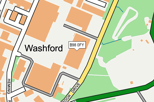
B98 0FY lies on Claybrook Drive in Redditch. B98 0FY is located in the Matchborough electoral ward, within the local authority district of Redditch and the English Parliamentary constituency of Redditch. The Sub Integrated Care Board (ICB) Location is NHS Herefordshire and Worcestershire ICB - 18C and the police force is West Mercia. This postcode has been in use since September 2006.


GetTheData
Source: OS OpenMap – Local (Ordnance Survey)
Source: OS VectorMap District (Ordnance Survey)
Licence: Open Government Licence (requires attribution)
| Easting | 407529 |
| Northing | 265649 |
| Latitude | 52.288941 |
| Longitude | -1.891033 |
GetTheData
Source: Open Postcode Geo
Licence: Open Government Licence
| Street | Claybrook Drive |
| Town/City | Redditch |
| Country | England |
| Postcode District | B98 |
➜ See where B98 is on a map ➜ Where is Redditch? | |
GetTheData
Source: Land Registry Price Paid Data
Licence: Open Government Licence
Elevation or altitude of B98 0FY as distance above sea level:
| Metres | Feet | |
|---|---|---|
| Elevation | 70m | 230ft |
Elevation is measured from the approximate centre of the postcode, to the nearest point on an OS contour line from OS Terrain 50, which has contour spacing of ten vertical metres.
➜ How high above sea level am I? Find the elevation of your current position using your device's GPS.
GetTheData
Source: Open Postcode Elevation
Licence: Open Government Licence
| Ward | Matchborough |
| Constituency | Redditch |
GetTheData
Source: ONS Postcode Database
Licence: Open Government Licence
| Claybrook Drive (Heming Road) | Washford | 160m |
| Claybrook Drive (Heming Road) | Washford | 177m |
| Washford Business Park (Matchborough Way) | Washford | 287m |
| Washford Business Park (Matchborough Way) | Washford | 304m |
| Arrow Valley Social Club (Matchborough Way) | Washford | 315m |
| Redditch Station | 4.2km |
| Danzey Station | 6.2km |
GetTheData
Source: NaPTAN
Licence: Open Government Licence
GetTheData
Source: ONS Postcode Database
Licence: Open Government Licence


➜ Get more ratings from the Food Standards Agency
GetTheData
Source: Food Standards Agency
Licence: FSA terms & conditions
| Last Collection | |||
|---|---|---|---|
| Location | Mon-Fri | Sat | Distance |
| Outside ""the Boot"" Public Hous | 16:30 | 08:00 | 410m |
| Hopyard Lane | 17:45 | 11:30 | 844m |
| Entrance To Studley College | 16:30 | 11:30 | 1,487m |
GetTheData
Source: Dracos
Licence: Creative Commons Attribution-ShareAlike
The below table lists the International Territorial Level (ITL) codes (formerly Nomenclature of Territorial Units for Statistics (NUTS) codes) and Local Administrative Units (LAU) codes for B98 0FY:
| ITL 1 Code | Name |
|---|---|
| TLG | West Midlands (England) |
| ITL 2 Code | Name |
| TLG1 | Herefordshire, Worcestershire and Warwickshire |
| ITL 3 Code | Name |
| TLG12 | Worcestershire CC |
| LAU 1 Code | Name |
| E07000236 | Redditch |
GetTheData
Source: ONS Postcode Directory
Licence: Open Government Licence
The below table lists the Census Output Area (OA), Lower Layer Super Output Area (LSOA), and Middle Layer Super Output Area (MSOA) for B98 0FY:
| Code | Name | |
|---|---|---|
| OA | E00164577 | |
| LSOA | E01032265 | Redditch 009B |
| MSOA | E02006729 | Redditch 009 |
GetTheData
Source: ONS Postcode Directory
Licence: Open Government Licence
| B98 0EA | The Washford Industrial Estate | 124m |
| B98 0DP | The Washford Industrial Estate | 209m |
| B98 0DH | Heming Road | 289m |
| B80 7BH | Birmingham Road | 303m |
| B98 0DG | Bartleet Road | 325m |
| B80 7BL | Birmingham Road | 359m |
| B80 7BP | Orchard Place | 370m |
| B98 0BN | Haseley Close | 393m |
| B98 0BW | Haseley Close | 399m |
| B98 0BQ | Farnborough Close | 405m |
GetTheData
Source: Open Postcode Geo; Land Registry Price Paid Data
Licence: Open Government Licence