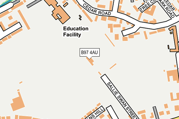
B97 4AU is located in the Central electoral ward, within the local authority district of Redditch and the English Parliamentary constituency of Redditch. The Sub Integrated Care Board (ICB) Location is NHS Herefordshire and Worcestershire ICB - 18C and the police force is West Mercia. This postcode has been in use since July 2017.


GetTheData
Source: OS OpenMap – Local (Ordnance Survey)
Source: OS VectorMap District (Ordnance Survey)
Licence: Open Government Licence (requires attribution)
| Easting | 403363 |
| Northing | 267711 |
| Latitude | 52.307519 |
| Longitude | -1.952089 |
GetTheData
Source: Open Postcode Geo
Licence: Open Government Licence
| Country | England |
| Postcode District | B97 |
➜ See where B97 is on a map ➜ Where is Redditch? | |
GetTheData
Source: Land Registry Price Paid Data
Licence: Open Government Licence
| Ward | Central |
| Constituency | Redditch |
GetTheData
Source: ONS Postcode Database
Licence: Open Government Licence
| Cedar Road Social Club (Cedar Road) | Batchley | 172m |
| Cedar View (Cedar Road) | Batchley | 173m |
| Cedar Road Social Club (Cedar Road) | Batchley | 175m |
| Cedar View (Cedar Road) | Batchley | 205m |
| Cedar Park Road (Cedar Road) | Batchley | 208m |
| Redditch Station | 0.5km |
| Alvechurch Station | 4.4km |
GetTheData
Source: NaPTAN
Licence: Open Government Licence
GetTheData
Source: ONS Postcode Database
Licence: Open Government Licence


➜ Get more ratings from the Food Standards Agency
GetTheData
Source: Food Standards Agency
Licence: FSA terms & conditions
| Last Collection | |||
|---|---|---|---|
| Location | Mon-Fri | Sat | Distance |
| Vg Stores 106 Bromsgrove Road | 17:30 | 11:30 | 255m |
| Edward St | 17:30 | 11:30 | 410m |
| Batchley Post Office | 17:30 | 12:00 | 423m |
GetTheData
Source: Dracos
Licence: Creative Commons Attribution-ShareAlike
The below table lists the International Territorial Level (ITL) codes (formerly Nomenclature of Territorial Units for Statistics (NUTS) codes) and Local Administrative Units (LAU) codes for B97 4AU:
| ITL 1 Code | Name |
|---|---|
| TLG | West Midlands (England) |
| ITL 2 Code | Name |
| TLG1 | Herefordshire, Worcestershire and Warwickshire |
| ITL 3 Code | Name |
| TLG12 | Worcestershire CC |
| LAU 1 Code | Name |
| E07000236 | Redditch |
GetTheData
Source: ONS Postcode Directory
Licence: Open Government Licence
The below table lists the Census Output Area (OA), Lower Layer Super Output Area (LSOA), and Middle Layer Super Output Area (MSOA) for B97 4AU:
| Code | Name | |
|---|---|---|
| OA | E00164448 | |
| LSOA | E01032238 | Redditch 006C |
| MSOA | E02006726 | Redditch 006 |
GetTheData
Source: ONS Postcode Directory
Licence: Open Government Licence
| B97 6HN | Cedar Road | 147m |
| B97 4RW | Lowans Hill View | 184m |
| B97 4RN | Bromsgrove Road | 226m |
| B97 6HL | Cedar Road | 228m |
| B97 4SA | Bromsgrove Road | 230m |
| B97 6HW | Cedar View | 259m |
| B97 6JF | Fir Tree Close | 260m |
| B97 4RL | Bromsgrove Road | 261m |
| B97 6HS | Bridley Moor Road | 272m |
| B97 4RJ | Bromsgrove Road | 284m |
GetTheData
Source: Open Postcode Geo; Land Registry Price Paid Data
Licence: Open Government Licence