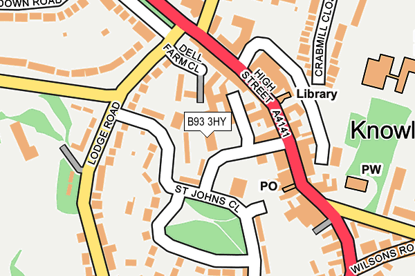
B93 3HY is located in the Knowle electoral ward, within the metropolitan district of Solihull and the English Parliamentary constituency of Meriden. The Sub Integrated Care Board (ICB) Location is NHS Birmingham and Solihull ICB - 15E and the police force is West Midlands. This postcode has been in use since March 2015.


GetTheData
Source: OS OpenMap – Local (Ordnance Survey)
Source: OS VectorMap District (Ordnance Survey)
Licence: Open Government Licence (requires attribution)
| Easting | 418027 |
| Northing | 276800 |
| Latitude | 52.388933 |
| Longitude | -1.736540 |
GetTheData
Source: Open Postcode Geo
Licence: Open Government Licence
| Country | England |
| Postcode District | B93 |
➜ See where B93 is on a map ➜ Where is Knowle? | |
GetTheData
Source: Land Registry Price Paid Data
Licence: Open Government Licence
Elevation or altitude of B93 3HY as distance above sea level:
| Metres | Feet | |
|---|---|---|
| Elevation | 120m | 394ft |
Elevation is measured from the approximate centre of the postcode, to the nearest point on an OS contour line from OS Terrain 50, which has contour spacing of ten vertical metres.
➜ How high above sea level am I? Find the elevation of your current position using your device's GPS.
GetTheData
Source: Open Postcode Elevation
Licence: Open Government Licence
| Ward | Knowle |
| Constituency | Meriden |
GetTheData
Source: ONS Postcode Database
Licence: Open Government Licence
| Wilsons Arms (High St) | Knowle | 133m |
| Knowle Green Church (High St) | Knowle | 169m |
| Lodge Rd (Warwick Road) | Knowle | 186m |
| Knowle Green Church (High St) | Knowle | 198m |
| St Johns Close (Station Rd) | Knowle | 283m |
| Dorridge Station | 2.2km |
| Widney Manor Station | 2.7km |
| Solihull Station | 4.5km |
GetTheData
Source: NaPTAN
Licence: Open Government Licence
GetTheData
Source: ONS Postcode Database
Licence: Open Government Licence


➜ Get more ratings from the Food Standards Agency
GetTheData
Source: Food Standards Agency
Licence: FSA terms & conditions
| Last Collection | |||
|---|---|---|---|
| Location | Mon-Fri | Sat | Distance |
| Knowle Delivery Office | 18:30 | 12:00 | 23m |
| Knowle Post Office | 17:15 | 12:00 | 115m |
| Milverton Road / Warwick Road | 17:45 | 08:30 | 341m |
GetTheData
Source: Dracos
Licence: Creative Commons Attribution-ShareAlike
The below table lists the International Territorial Level (ITL) codes (formerly Nomenclature of Territorial Units for Statistics (NUTS) codes) and Local Administrative Units (LAU) codes for B93 3HY:
| ITL 1 Code | Name |
|---|---|
| TLG | West Midlands (England) |
| ITL 2 Code | Name |
| TLG3 | West Midlands |
| ITL 3 Code | Name |
| TLG32 | Solihull |
| LAU 1 Code | Name |
| E08000029 | Solihull |
GetTheData
Source: ONS Postcode Directory
Licence: Open Government Licence
The below table lists the Census Output Area (OA), Lower Layer Super Output Area (LSOA), and Middle Layer Super Output Area (MSOA) for B93 3HY:
| Code | Name | |
|---|---|---|
| OA | E00051349 | |
| LSOA | E01010151 | Solihull 026A |
| MSOA | E02002106 | Solihull 026 |
GetTheData
Source: ONS Postcode Directory
Licence: Open Government Licence
| B93 0NH | St Johns Close | 34m |
| B93 0LE | St Johns Way | 66m |
| B93 0JX | Dell Farm Close | 82m |
| B93 0JU | High Street | 90m |
| B93 0NL | St Johns Close | 104m |
| B93 0NA | High Street | 116m |
| B93 0HD | Lodge Road | 119m |
| B93 0LF | High Street | 129m |
| B93 0LL | High Street | 140m |
| B93 0HE | Lodge Road | 172m |
GetTheData
Source: Open Postcode Geo; Land Registry Price Paid Data
Licence: Open Government Licence