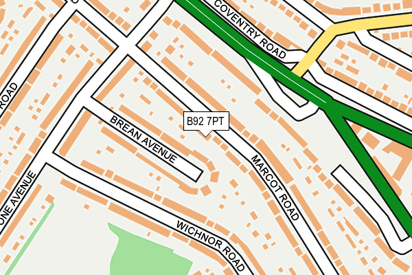
B92 7PT lies on Marcot Road in Solihull. B92 7PT is located in the Lyndon electoral ward, within the metropolitan district of Solihull and the English Parliamentary constituency of Solihull. The Sub Integrated Care Board (ICB) Location is NHS Birmingham and Solihull ICB - 15E and the police force is West Midlands. This postcode has been in use since January 1980.


GetTheData
Source: OS OpenMap – Local (Ordnance Survey)
Source: OS VectorMap District (Ordnance Survey)
Licence: Open Government Licence (requires attribution)
| Easting | 413714 |
| Northing | 284366 |
| Latitude | 52.457075 |
| Longitude | -1.799606 |
GetTheData
Source: Open Postcode Geo
Licence: Open Government Licence
| Street | Marcot Road |
| Town/City | Solihull |
| Country | England |
| Postcode District | B92 |
➜ See where B92 is on a map ➜ Where is Solihull? | |
GetTheData
Source: Land Registry Price Paid Data
Licence: Open Government Licence
Elevation or altitude of B92 7PT as distance above sea level:
| Metres | Feet | |
|---|---|---|
| Elevation | 120m | 394ft |
Elevation is measured from the approximate centre of the postcode, to the nearest point on an OS contour line from OS Terrain 50, which has contour spacing of ten vertical metres.
➜ How high above sea level am I? Find the elevation of your current position using your device's GPS.
GetTheData
Source: Open Postcode Elevation
Licence: Open Government Licence
| Ward | Lyndon |
| Constituency | Solihull |
GetTheData
Source: ONS Postcode Database
Licence: Open Government Licence
2021 23 NOV £242,500 |
2002 30 AUG £125,000 |
2001 1 JUN £92,000 |
GetTheData
Source: HM Land Registry Price Paid Data
Licence: Contains HM Land Registry data © Crown copyright and database right 2025. This data is licensed under the Open Government Licence v3.0.
| Brays Rd (Coventry Rd) | Lyndon End | 163m |
| Gilbertstone Avenue (Coventry Rd) | Lyndon End | 170m |
| Gotham Rd (Gilbertstone Ave) | Lyndon End | 175m |
| Gotham Rd (Gilbertstone Ave) | Lyndon End | 190m |
| Wichnor Rd (Gilbertstone Ave) | Lyndon End | 200m |
| Acocks Green Station | 1.6km |
| Olton Station | 2.1km |
| Tyseley Station | 2.7km |
GetTheData
Source: NaPTAN
Licence: Open Government Licence
| Percentage of properties with Next Generation Access | 100.0% |
| Percentage of properties with Superfast Broadband | 100.0% |
| Percentage of properties with Ultrafast Broadband | 100.0% |
| Percentage of properties with Full Fibre Broadband | 100.0% |
Superfast Broadband is between 30Mbps and 300Mbps
Ultrafast Broadband is > 300Mbps
| Median download speed | 73.9Mbps |
| Average download speed | 77.4Mbps |
| Maximum download speed | 200.00Mbps |
| Median upload speed | 1.1Mbps |
| Average upload speed | 6.8Mbps |
| Maximum upload speed | 20.00Mbps |
| Percentage of properties unable to receive 2Mbps | 0.0% |
| Percentage of properties unable to receive 5Mbps | 0.0% |
| Percentage of properties unable to receive 10Mbps | 0.0% |
| Percentage of properties unable to receive 30Mbps | 0.0% |
GetTheData
Source: Ofcom
Licence: Ofcom Terms of Use (requires attribution)
Estimated total energy consumption in B92 7PT by fuel type, 2015.
| Consumption (kWh) | 474,654 |
|---|---|
| Meter count | 38 |
| Mean (kWh/meter) | 12,491 |
| Median (kWh/meter) | 11,433 |
| Consumption (kWh) | 110,585 |
|---|---|
| Meter count | 33 |
| Mean (kWh/meter) | 3,351 |
| Median (kWh/meter) | 3,174 |
GetTheData
Source: Postcode level gas estimates: 2015 (experimental)
Source: Postcode level electricity estimates: 2015 (experimental)
Licence: Open Government Licence
GetTheData
Source: ONS Postcode Database
Licence: Open Government Licence


➜ Get more ratings from the Food Standards Agency
GetTheData
Source: Food Standards Agency
Licence: FSA terms & conditions
| Last Collection | |||
|---|---|---|---|
| Location | Mon-Fri | Sat | Distance |
| Gotham Road / Marcot Road Gilberts | 17:15 | 11:30 | 173m |
| Marcot Road / Wichnor Road | 17:30 | 12:00 | 293m |
| Gilberstone Post Office | 17:45 | 11:30 | 476m |
GetTheData
Source: Dracos
Licence: Creative Commons Attribution-ShareAlike
The below table lists the International Territorial Level (ITL) codes (formerly Nomenclature of Territorial Units for Statistics (NUTS) codes) and Local Administrative Units (LAU) codes for B92 7PT:
| ITL 1 Code | Name |
|---|---|
| TLG | West Midlands (England) |
| ITL 2 Code | Name |
| TLG3 | West Midlands |
| ITL 3 Code | Name |
| TLG32 | Solihull |
| LAU 1 Code | Name |
| E08000029 | Solihull |
GetTheData
Source: ONS Postcode Directory
Licence: Open Government Licence
The below table lists the Census Output Area (OA), Lower Layer Super Output Area (LSOA), and Middle Layer Super Output Area (MSOA) for B92 7PT:
| Code | Name | |
|---|---|---|
| OA | E00051364 | |
| LSOA | E01010162 | Solihull 010C |
| MSOA | E02002090 | Solihull 010 |
GetTheData
Source: ONS Postcode Directory
Licence: Open Government Licence
| B92 7PS | Marcot Road | 45m |
| B26 1JS | Brean Avenue | 81m |
| B92 7PX | Wichnor Road | 108m |
| B26 1JP | Coventry Road | 120m |
| B92 7QA | Wichnor Road | 155m |
| B26 1JR | Gilbertstone Avenue | 162m |
| B26 1PA | Coventry Road | 205m |
| B26 1LD | Gilbertstone Avenue | 213m |
| B26 1JT | Gilbertstone Avenue | 218m |
| B26 3BA | New Coventry Road | 218m |
GetTheData
Source: Open Postcode Geo; Land Registry Price Paid Data
Licence: Open Government Licence