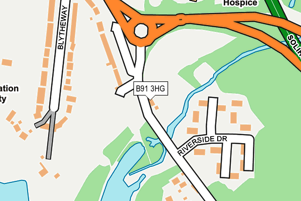
B91 3HG lies on Warwick Road in Solihull. B91 3HG is located in the Silhill electoral ward, within the metropolitan district of Solihull and the English Parliamentary constituency of Solihull. The Sub Integrated Care Board (ICB) Location is NHS Birmingham and Solihull ICB - 15E and the police force is West Midlands. This postcode has been in use since January 1980.


GetTheData
Source: OS OpenMap – Local (Ordnance Survey)
Source: OS VectorMap District (Ordnance Survey)
Licence: Open Government Licence (requires attribution)
| Easting | 416326 |
| Northing | 279025 |
| Latitude | 52.408989 |
| Longitude | -1.761426 |
GetTheData
Source: Open Postcode Geo
Licence: Open Government Licence
| Street | Warwick Road |
| Town/City | Solihull |
| Country | England |
| Postcode District | B91 |
➜ See where B91 is on a map ➜ Where is Solihull? | |
GetTheData
Source: Land Registry Price Paid Data
Licence: Open Government Licence
Elevation or altitude of B91 3HG as distance above sea level:
| Metres | Feet | |
|---|---|---|
| Elevation | 110m | 361ft |
Elevation is measured from the approximate centre of the postcode, to the nearest point on an OS contour line from OS Terrain 50, which has contour spacing of ten vertical metres.
➜ How high above sea level am I? Find the elevation of your current position using your device's GPS.
GetTheData
Source: Open Postcode Elevation
Licence: Open Government Licence
| Ward | Silhill |
| Constituency | Solihull |
GetTheData
Source: ONS Postcode Database
Licence: Open Government Licence
1021, WARWICK ROAD, SOLIHULL, B91 3HG 2016 2 FEB £780,000 |
1021, WARWICK ROAD, SOLIHULL, B91 3HG 2006 13 OCT £750,000 |
1021, WARWICK ROAD, SOLIHULL, B91 3HG 2004 26 JAN £570,000 |
GetTheData
Source: HM Land Registry Price Paid Data
Licence: Contains HM Land Registry data © Crown copyright and database right 2025. This data is licensed under the Open Government Licence v3.0.
| Marsh Lane (Warwick Road) | Solihull | 195m |
| Marsh Lane (Warwick Road) | Solihull | 197m |
| Brueton Avenue (Warwick Road) | Solihull | 627m |
| Brueton Avenue (Warwick Road) | Solihull | 649m |
| Ravenshaw Way (Solihull By-pass) | Copt Heath | 682m |
| Widney Manor Station | 1.7km |
| Solihull Station | 1.9km |
| Dorridge Station | 4.1km |
GetTheData
Source: NaPTAN
Licence: Open Government Licence
GetTheData
Source: ONS Postcode Database
Licence: Open Government Licence


➜ Get more ratings from the Food Standards Agency
GetTheData
Source: Food Standards Agency
Licence: FSA terms & conditions
| Last Collection | |||
|---|---|---|---|
| Location | Mon-Fri | Sat | Distance |
| Sandalls Bridge | 17:30 | 12:00 | 166m |
| Marsh Lane | 17:30 | 12:00 | 354m |
| 24 New Road | 17:45 | 12:00 | 830m |
GetTheData
Source: Dracos
Licence: Creative Commons Attribution-ShareAlike
| Risk of B91 3HG flooding from rivers and sea | Medium |
| ➜ B91 3HG flood map | |
GetTheData
Source: Open Flood Risk by Postcode
Licence: Open Government Licence
The below table lists the International Territorial Level (ITL) codes (formerly Nomenclature of Territorial Units for Statistics (NUTS) codes) and Local Administrative Units (LAU) codes for B91 3HG:
| ITL 1 Code | Name |
|---|---|
| TLG | West Midlands (England) |
| ITL 2 Code | Name |
| TLG3 | West Midlands |
| ITL 3 Code | Name |
| TLG32 | Solihull |
| LAU 1 Code | Name |
| E08000029 | Solihull |
GetTheData
Source: ONS Postcode Directory
Licence: Open Government Licence
The below table lists the Census Output Area (OA), Lower Layer Super Output Area (LSOA), and Middle Layer Super Output Area (MSOA) for B91 3HG:
| Code | Name | |
|---|---|---|
| OA | E00051717 | |
| LSOA | E01010226 | Solihull 016B |
| MSOA | E02002096 | Solihull 016 |
GetTheData
Source: ONS Postcode Directory
Licence: Open Government Licence
| B91 3HH | Riverside Drive | 139m |
| B91 3HA | Warwick Road | 157m |
| B91 3HR | Riverside Drive | 197m |
| B91 3EY | Blythe Way | 221m |
| B91 3HW | Warwick Road | 245m |
| B91 2PG | Marsh Lane | 359m |
| B91 3EX | Warwick Road | 387m |
| B91 3EU | Warwick Road | 389m |
| B91 3EN | Brueton Avenue | 394m |
| B91 2QY | Gillott Close | 410m |
GetTheData
Source: Open Postcode Geo; Land Registry Price Paid Data
Licence: Open Government Licence