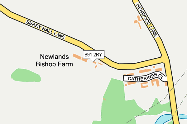
B91 2RY is located in the Bickenhill electoral ward, within the metropolitan district of Solihull and the English Parliamentary constituency of Meriden. The Sub Integrated Care Board (ICB) Location is NHS Birmingham and Solihull ICB - 15E and the police force is West Midlands. This postcode has been in use since May 2004.


GetTheData
Source: OS OpenMap – Local (Ordnance Survey)
Source: OS VectorMap District (Ordnance Survey)
Licence: Open Government Licence (requires attribution)
| Easting | 417707 |
| Northing | 279747 |
| Latitude | 52.415437 |
| Longitude | -1.741087 |
GetTheData
Source: Open Postcode Geo
Licence: Open Government Licence
| Country | England |
| Postcode District | B91 |
➜ See where B91 is on a map | |
GetTheData
Source: Land Registry Price Paid Data
Licence: Open Government Licence
Elevation or altitude of B91 2RY as distance above sea level:
| Metres | Feet | |
|---|---|---|
| Elevation | 120m | 394ft |
Elevation is measured from the approximate centre of the postcode, to the nearest point on an OS contour line from OS Terrain 50, which has contour spacing of ten vertical metres.
➜ How high above sea level am I? Find the elevation of your current position using your device's GPS.
GetTheData
Source: Open Postcode Elevation
Licence: Open Government Licence
| Ward | Bickenhill |
| Constituency | Meriden |
GetTheData
Source: ONS Postcode Database
Licence: Open Government Licence
| The Boat Inn (Hampton Lane) | Catherine De Barnes Heath | 602m |
| The Boat Inn (Hampton Lane) | Catherine De Barnes Heath | 648m |
| Field Lane (Hampton Lane) | Catherine De Barnes Heath | 693m |
| Field Lane (Hampton Lane) | Catherine De Barnes Heath | 700m |
| Friday Lane | Catherine De Barnes | 848m |
| Widney Manor Station | 3.1km |
| Hampton-in-Arden Station | 3.2km |
| Solihull Station | 3.2km |
GetTheData
Source: NaPTAN
Licence: Open Government Licence
GetTheData
Source: ONS Postcode Database
Licence: Open Government Licence


➜ Get more ratings from the Food Standards Agency
GetTheData
Source: Food Standards Agency
Licence: FSA terms & conditions
| Last Collection | |||
|---|---|---|---|
| Location | Mon-Fri | Sat | Distance |
| Catherine De Barnes | 15:45 | 07:00 | 616m |
| Catherine De Barnes Post Offic | 17:00 | 12:00 | 671m |
| 0pp 48 Hampton Lane | 17:00 | 12:00 | 1,061m |
GetTheData
Source: Dracos
Licence: Creative Commons Attribution-ShareAlike
The below table lists the International Territorial Level (ITL) codes (formerly Nomenclature of Territorial Units for Statistics (NUTS) codes) and Local Administrative Units (LAU) codes for B91 2RY:
| ITL 1 Code | Name |
|---|---|
| TLG | West Midlands (England) |
| ITL 2 Code | Name |
| TLG3 | West Midlands |
| ITL 3 Code | Name |
| TLG32 | Solihull |
| LAU 1 Code | Name |
| E08000029 | Solihull |
GetTheData
Source: ONS Postcode Directory
Licence: Open Government Licence
The below table lists the Census Output Area (OA), Lower Layer Super Output Area (LSOA), and Middle Layer Super Output Area (MSOA) for B91 2RY:
| Code | Name | |
|---|---|---|
| OA | E00051698 | |
| LSOA | E01010227 | Solihull 015C |
| MSOA | E02002095 | Solihull 015 |
GetTheData
Source: ONS Postcode Directory
Licence: Open Government Licence
| B91 2SZ | Catherines Close | 173m |
| B91 2RS | Hampton Lane | 577m |
| B91 2TD | Hampton Lane | 599m |
| B91 2TX | Foxley Drive | 612m |
| B91 2TJ | Hampton Lane | 651m |
| B91 2TQ | Appletree Close | 656m |
| B91 2TB | Ravenshaw Way | 668m |
| B91 2SY | Henwood Lane | 672m |
| B91 2TR | Oakfields Way | 688m |
| B91 2TL | Lugtrout Lane | 688m |
GetTheData
Source: Open Postcode Geo; Land Registry Price Paid Data
Licence: Open Government Licence