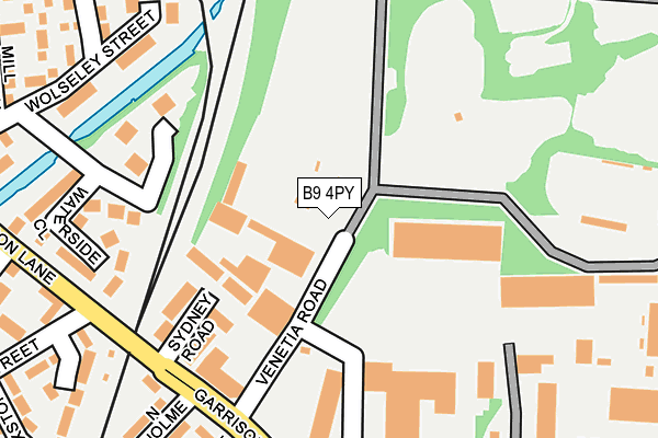
B9 4PY is located in the Bordesley & Highgate electoral ward, within the metropolitan district of Birmingham and the English Parliamentary constituency of Birmingham, Ladywood. The Sub Integrated Care Board (ICB) Location is NHS Birmingham and Solihull ICB - 15E and the police force is West Midlands. This postcode has been in use since January 1980.


GetTheData
Source: OS OpenMap – Local (Ordnance Survey)
Source: OS VectorMap District (Ordnance Survey)
Licence: Open Government Licence (requires attribution)
| Easting | 409158 |
| Northing | 286721 |
| Latitude | 52.478355 |
| Longitude | -1.866585 |
GetTheData
Source: Open Postcode Geo
Licence: Open Government Licence
| Country | England |
| Postcode District | B9 |
➜ See where B9 is on a map ➜ Where is Birmingham? | |
GetTheData
Source: Land Registry Price Paid Data
Licence: Open Government Licence
Elevation or altitude of B9 4PY as distance above sea level:
| Metres | Feet | |
|---|---|---|
| Elevation | 120m | 394ft |
Elevation is measured from the approximate centre of the postcode, to the nearest point on an OS contour line from OS Terrain 50, which has contour spacing of ten vertical metres.
➜ How high above sea level am I? Find the elevation of your current position using your device's GPS.
GetTheData
Source: Open Postcode Elevation
Licence: Open Government Licence
| Ward | Bordesley & Highgate |
| Constituency | Birmingham, Ladywood |
GetTheData
Source: ONS Postcode Database
Licence: Open Government Licence
| Venetia Rd (Garrison Lane) | Bordesley | 119m |
| Venetia Rd (Garrison Lane) | Bordesley | 135m |
| Maxstoke St (Garrison Lane) | Bordesley | 185m |
| Maxstoke St (Garrison Lane) | Bordesley | 235m |
| Tilton Rd (Garrison Lane) | Bordesley | 244m |
| Adderley Park Station | 0.9km |
| Bordesley Station | 1km |
| Duddeston Station | 1.2km |
GetTheData
Source: NaPTAN
Licence: Open Government Licence
GetTheData
Source: ONS Postcode Database
Licence: Open Government Licence


➜ Get more ratings from the Food Standards Agency
GetTheData
Source: Food Standards Agency
Licence: FSA terms & conditions
| Last Collection | |||
|---|---|---|---|
| Location | Mon-Fri | Sat | Distance |
| Grey Street | 18:30 | 11:30 | 279m |
| St Andrews Way / Kingston Road | 18:30 | 11:30 | 399m |
| Bordesley Green/ Prince Albert | 17:30 | 11:30 | 608m |
GetTheData
Source: Dracos
Licence: Creative Commons Attribution-ShareAlike
The below table lists the International Territorial Level (ITL) codes (formerly Nomenclature of Territorial Units for Statistics (NUTS) codes) and Local Administrative Units (LAU) codes for B9 4PY:
| ITL 1 Code | Name |
|---|---|
| TLG | West Midlands (England) |
| ITL 2 Code | Name |
| TLG3 | West Midlands |
| ITL 3 Code | Name |
| TLG31 | Birmingham |
| LAU 1 Code | Name |
| E08000025 | Birmingham |
GetTheData
Source: ONS Postcode Directory
Licence: Open Government Licence
The below table lists the Census Output Area (OA), Lower Layer Super Output Area (LSOA), and Middle Layer Super Output Area (MSOA) for B9 4PY:
| Code | Name | |
|---|---|---|
| OA | E00046616 | |
| LSOA | E01009199 | Birmingham 052D |
| MSOA | E02001878 | Birmingham 052 |
GetTheData
Source: ONS Postcode Directory
Licence: Open Government Licence
| B9 4QJ | Waterside Close | 200m |
| B9 4QH | Artillery Street | 218m |
| B9 4JQ | Maxstoke Street | 244m |
| B9 4NZ | Century Park | 256m |
| B9 4NW | Wolseley Street | 274m |
| B9 4PG | Hoff Beck Court | 287m |
| B9 4LS | Gray Street | 313m |
| B9 4PW | Mease Croft | 322m |
| B9 4JT | St Andrews Street | 324m |
| B9 4PL | Isbourne Way | 325m |
GetTheData
Source: Open Postcode Geo; Land Registry Price Paid Data
Licence: Open Government Licence