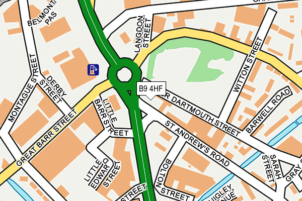
B9 4HF is located in the Bordesley & Highgate electoral ward, within the metropolitan district of Birmingham and the English Parliamentary constituency of Birmingham, Ladywood. The Sub Integrated Care Board (ICB) Location is NHS Birmingham and Solihull ICB - 15E and the police force is West Midlands. This postcode has been in use since January 1980.


GetTheData
Source: OS OpenMap – Local (Ordnance Survey)
Source: OS VectorMap District (Ordnance Survey)
Licence: Open Government Licence (requires attribution)
| Easting | 408549 |
| Northing | 286820 |
| Latitude | 52.479255 |
| Longitude | -1.875550 |
GetTheData
Source: Open Postcode Geo
Licence: Open Government Licence
| Country | England |
| Postcode District | B9 |
➜ See where B9 is on a map ➜ Where is Birmingham? | |
GetTheData
Source: Land Registry Price Paid Data
Licence: Open Government Licence
Elevation or altitude of B9 4HF as distance above sea level:
| Metres | Feet | |
|---|---|---|
| Elevation | 100m | 328ft |
Elevation is measured from the approximate centre of the postcode, to the nearest point on an OS contour line from OS Terrain 50, which has contour spacing of ten vertical metres.
➜ How high above sea level am I? Find the elevation of your current position using your device's GPS.
GetTheData
Source: Open Postcode Elevation
Licence: Open Government Licence
| Ward | Bordesley & Highgate |
| Constituency | Birmingham, Ladywood |
GetTheData
Source: ONS Postcode Database
Licence: Open Government Licence
| Lawley Middleway (Garrison Lane) | Deritend | 141m |
| Derby St (Great Barr St) | Deritend | 146m |
| Derby St (Great Barr St) | Deritend | 200m |
| Witton St (Garrison Lane) | Bordesley | 215m |
| Witton St (Garrison Lane) | Bordesley | 226m |
| Bull Street (Midland Metro Stop) (Bull Street) | Birmingham | 1,440m |
| Corporation Street (Midland Metro Stop) (Corporation Street) | Birmingham | 1,470m |
| Bordesley Station | 0.8km |
| Duddeston Station | 1.1km |
| Birmingham Moor Street Station | 1.1km |
GetTheData
Source: NaPTAN
Licence: Open Government Licence
GetTheData
Source: ONS Postcode Database
Licence: Open Government Licence
➜ Get more ratings from the Food Standards Agency
GetTheData
Source: Food Standards Agency
Licence: FSA terms & conditions
| Last Collection | |||
|---|---|---|---|
| Location | Mon-Fri | Sat | Distance |
| Midway Along Glover St | 18:30 | 11:30 | 336m |
| Grey Street | 18:30 | 11:30 | 342m |
| Eastern D /O | 17:30 | 11:30 | 395m |
GetTheData
Source: Dracos
Licence: Creative Commons Attribution-ShareAlike
The below table lists the International Territorial Level (ITL) codes (formerly Nomenclature of Territorial Units for Statistics (NUTS) codes) and Local Administrative Units (LAU) codes for B9 4HF:
| ITL 1 Code | Name |
|---|---|
| TLG | West Midlands (England) |
| ITL 2 Code | Name |
| TLG3 | West Midlands |
| ITL 3 Code | Name |
| TLG31 | Birmingham |
| LAU 1 Code | Name |
| E08000025 | Birmingham |
GetTheData
Source: ONS Postcode Directory
Licence: Open Government Licence
The below table lists the Census Output Area (OA), Lower Layer Super Output Area (LSOA), and Middle Layer Super Output Area (MSOA) for B9 4HF:
| Code | Name | |
|---|---|---|
| OA | E00046654 | |
| LSOA | E01009200 | Birmingham 139A |
| MSOA | E02006900 | Birmingham 139 |
GetTheData
Source: ONS Postcode Directory
Licence: Open Government Licence
| B9 4BP | Langdon Street | 121m |
| B9 4LH | Witton Street | 167m |
| B9 4LJ | Park Villas | 190m |
| B9 4LN | St Andrews Road | 191m |
| B9 4LB | Barwell Road | 219m |
| B9 4LA | Lower Dartmouth Street | 285m |
| B9 4BN | Garrison Street | 295m |
| B9 4PQ | Keer Court | 318m |
| B9 4PJ | Alport Croft | 318m |
| B9 4LS | Gray Street | 342m |
GetTheData
Source: Open Postcode Geo; Land Registry Price Paid Data
Licence: Open Government Licence