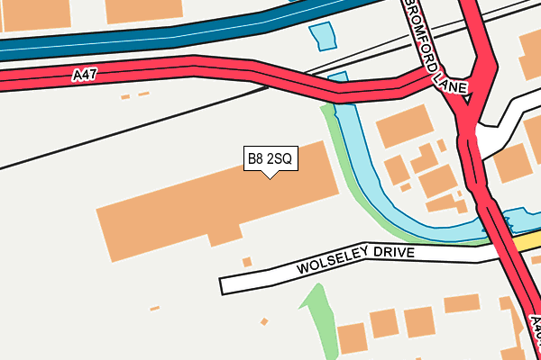
B8 2SQ lies on Wolseley Drive in Birmingham. B8 2SQ is located in the Ward End electoral ward, within the metropolitan district of Birmingham and the English Parliamentary constituency of Birmingham, Hodge Hill. The Sub Integrated Care Board (ICB) Location is NHS Birmingham and Solihull ICB - 15E and the police force is West Midlands. This postcode has been in use since June 1981.


GetTheData
Source: OS OpenMap – Local (Ordnance Survey)
Source: OS VectorMap District (Ordnance Survey)
Licence: Open Government Licence (requires attribution)
| Easting | 411374 |
| Northing | 289531 |
| Latitude | 52.503561 |
| Longitude | -1.833868 |
GetTheData
Source: Open Postcode Geo
Licence: Open Government Licence
| Street | Wolseley Drive |
| Town/City | Birmingham |
| Country | England |
| Postcode District | B8 |
➜ See where B8 is on a map ➜ Where is Birmingham? | |
GetTheData
Source: Land Registry Price Paid Data
Licence: Open Government Licence
Elevation or altitude of B8 2SQ as distance above sea level:
| Metres | Feet | |
|---|---|---|
| Elevation | 90m | 295ft |
Elevation is measured from the approximate centre of the postcode, to the nearest point on an OS contour line from OS Terrain 50, which has contour spacing of ten vertical metres.
➜ How high above sea level am I? Find the elevation of your current position using your device's GPS.
GetTheData
Source: Open Postcode Elevation
Licence: Open Government Licence
| Ward | Ward End |
| Constituency | Birmingham, Hodge Hill |
GetTheData
Source: ONS Postcode Database
Licence: Open Government Licence
| The Bromford (Bromford Lane) | Bromford Bridge | 278m |
| Ingleton Rd (Drews Lane) | Bromford Bridge | 284m |
| Motorway Bridge (Bromford Lane) | Bromford Bridge | 315m |
| The Bromford (Drews Lane) | Bromford Bridge | 319m |
| Motorway Bridge (Bromford Lane) | Bromford Bridge | 336m |
| Gravelly Hill Station | 1.8km |
| Aston Station | 2.6km |
| Stechford Station | 2.6km |
GetTheData
Source: NaPTAN
Licence: Open Government Licence
GetTheData
Source: ONS Postcode Database
Licence: Open Government Licence


➜ Get more ratings from the Food Standards Agency
GetTheData
Source: Food Standards Agency
Licence: FSA terms & conditions
| Last Collection | |||
|---|---|---|---|
| Location | Mon-Fri | Sat | Distance |
| Drews Lane Post Office | 17:30 | 11:30 | 399m |
| Ingleton Road / Ward End Road | 17:30 | 11:30 | 607m |
| Bromford Post Office | 17:45 | 12:30 | 730m |
GetTheData
Source: Dracos
Licence: Creative Commons Attribution-ShareAlike
The below table lists the International Territorial Level (ITL) codes (formerly Nomenclature of Territorial Units for Statistics (NUTS) codes) and Local Administrative Units (LAU) codes for B8 2SQ:
| ITL 1 Code | Name |
|---|---|
| TLG | West Midlands (England) |
| ITL 2 Code | Name |
| TLG3 | West Midlands |
| ITL 3 Code | Name |
| TLG31 | Birmingham |
| LAU 1 Code | Name |
| E08000025 | Birmingham |
GetTheData
Source: ONS Postcode Directory
Licence: Open Government Licence
The below table lists the Census Output Area (OA), Lower Layer Super Output Area (LSOA), and Middle Layer Super Output Area (MSOA) for B8 2SQ:
| Code | Name | |
|---|---|---|
| OA | E00047990 | |
| LSOA | E01009478 | Birmingham 048A |
| MSOA | E02001874 | Birmingham 048 |
GetTheData
Source: ONS Postcode Directory
Licence: Open Government Licence
| B8 2SG | Bromford Lane | 174m |
| B8 2SL | Drews Lane | 272m |
| B8 2SJ | Drews Lane | 311m |
| B8 2QF | Drews Lane | 339m |
| B8 2QR | Tufnell Grove | 359m |
| B36 8HU | Bromford Road | 388m |
| B8 2QW | Ingleton Road | 403m |
| B8 2QP | Northleigh Road | 446m |
| B8 2RY | Bromford Lane | 462m |
| B8 2RZ | Bromford Lane | 462m |
GetTheData
Source: Open Postcode Geo; Land Registry Price Paid Data
Licence: Open Government Licence