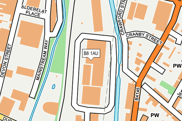
B8 1AU is located in the Alum Rock electoral ward, within the metropolitan district of Birmingham and the English Parliamentary constituency of Birmingham, Hodge Hill. The Sub Integrated Care Board (ICB) Location is NHS Birmingham and Solihull ICB - 15E and the police force is West Midlands. This postcode has been in use since December 2001.


GetTheData
Source: OS OpenMap – Local (Ordnance Survey)
Source: OS VectorMap District (Ordnance Survey)
Licence: Open Government Licence (requires attribution)
| Easting | 409341 |
| Northing | 287948 |
| Latitude | 52.489383 |
| Longitude | -1.863857 |
GetTheData
Source: Open Postcode Geo
Licence: Open Government Licence
| Country | England |
| Postcode District | B8 |
➜ See where B8 is on a map ➜ Where is Birmingham? | |
GetTheData
Source: Land Registry Price Paid Data
Licence: Open Government Licence
Elevation or altitude of B8 1AU as distance above sea level:
| Metres | Feet | |
|---|---|---|
| Elevation | 100m | 328ft |
Elevation is measured from the approximate centre of the postcode, to the nearest point on an OS contour line from OS Terrain 50, which has contour spacing of ten vertical metres.
➜ How high above sea level am I? Find the elevation of your current position using your device's GPS.
GetTheData
Source: Open Postcode Elevation
Licence: Open Government Licence
| Ward | Alum Rock |
| Constituency | Birmingham, Hodge Hill |
GetTheData
Source: ONS Postcode Database
Licence: Open Government Licence
| Crawford Street (Adderley Rd) | Saltley | 154m |
| Crawford St (Adderley Rd) | Duddeston | 164m |
| Crawford St (Adderley Rd) | Duddeston | 175m |
| Adderley Road (Ash Rd) | Duddeston | 253m |
| Alderflat Place | Saltley | 299m |
| Duddeston Station | 0.5km |
| Adderley Park Station | 0.9km |
| Aston Station | 1.7km |
GetTheData
Source: NaPTAN
Licence: Open Government Licence
Estimated total energy consumption in B8 1AU by fuel type, 2015.
| Consumption (kWh) | 365,519 |
|---|---|
| Meter count | 16 |
| Mean (kWh/meter) | 22,845 |
| Median (kWh/meter) | 22,375 |
GetTheData
Source: Postcode level gas estimates: 2015 (experimental)
Source: Postcode level electricity estimates: 2015 (experimental)
Licence: Open Government Licence
GetTheData
Source: ONS Postcode Database
Licence: Open Government Licence


➜ Get more ratings from the Food Standards Agency
GetTheData
Source: Food Standards Agency
Licence: FSA terms & conditions
| Last Collection | |||
|---|---|---|---|
| Location | Mon-Fri | Sat | Distance |
| Ash Road / Hall Road | 17:30 | 11:30 | 396m |
| Duddeston Mill Road | 18:30 | 12:30 | 427m |
| Vauxhall | 17:30 | 12:30 | 577m |
GetTheData
Source: Dracos
Licence: Creative Commons Attribution-ShareAlike
| Risk of B8 1AU flooding from rivers and sea | Low |
| ➜ B8 1AU flood map | |
GetTheData
Source: Open Flood Risk by Postcode
Licence: Open Government Licence
The below table lists the International Territorial Level (ITL) codes (formerly Nomenclature of Territorial Units for Statistics (NUTS) codes) and Local Administrative Units (LAU) codes for B8 1AU:
| ITL 1 Code | Name |
|---|---|
| TLG | West Midlands (England) |
| ITL 2 Code | Name |
| TLG3 | West Midlands |
| ITL 3 Code | Name |
| TLG31 | Birmingham |
| LAU 1 Code | Name |
| E08000025 | Birmingham |
GetTheData
Source: ONS Postcode Directory
Licence: Open Government Licence
The below table lists the Census Output Area (OA), Lower Layer Super Output Area (LSOA), and Middle Layer Super Output Area (MSOA) for B8 1AU:
| Code | Name | |
|---|---|---|
| OA | E00046626 | |
| LSOA | E01033644 | Birmingham 052F |
| MSOA | E02001878 | Birmingham 052 |
GetTheData
Source: ONS Postcode Directory
Licence: Open Government Licence
| B8 1JL | Crawford Street | 158m |
| B8 1HL | St Saviours Road | 218m |
| B8 1LB | Adderley Gardens | 258m |
| B8 1EG | Adderley Road | 262m |
| B8 1DJ | Ash Road | 302m |
| B8 1HN | St Saviours Road | 310m |
| B8 1DN | Ashley Gardens | 311m |
| B8 1DW | Ash Road | 312m |
| B8 1HJ | St Saviours Road | 317m |
| B8 1LP | Jersey Road | 318m |
GetTheData
Source: Open Postcode Geo; Land Registry Price Paid Data
Licence: Open Government Licence